Farsund
![]()
Farsund kommune | |
|---|---|
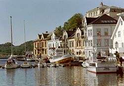 View of the Farsund town harbour | |
 Coat of arms 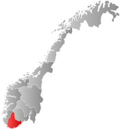 Agder within Norway | |
 Farsund within Agder | |
| Coordinates: 58°04′58″N 06°45′10″E | |
| Country | Norway |
| County | Agder |
| District | Lister |
| Administrative centre | Farsund |
| Government | |
| • Mayor (2015) | Arnt Abrahamsen (Ap) |
| Area | |
| • Total | 262.55 km2 (101.37 sq mi) |
| • Land | 251.83 km2 (97.23 sq mi) |
| • Water | 10.72 km2 (4.14 sq mi) |
| Area rank | 292 in Norway |
| Population (2017) | |
| • Total | 9,769 |
| • Rank | 115 in Norway |
| • Density | 38.8/km2 (100/sq mi) |
| • Change (10 years) | 4.1% |
| Demonym(s) | Farsunder or Farsundar (also Listelending or Listring)[1] |
| Time zone | UTC+01:00 (CET) |
| • Summer (DST) | UTC+02:00 (CEST) |
| ISO 3166 code | NO-4206 |
| Official language form | Bokmål[2] |
| Website | www |
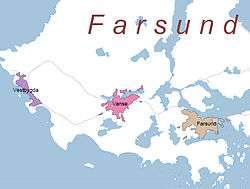
The 263-square-kilometre (102 sq mi) municipality is the 272nd largest by area out of the 356 municipalities in Norway. Farsund is the 109th most populous municipality in Norway with a population of 9,769. The municipality's population density is 38.8 inhabitants per square kilometre (100/sq mi) and its population has increased by 4.1% over the last decade.[3] The inhabitants of Farsund are concentrated in three centres of population: the town of Farsund (population: 3,265), Vanse (population: 2,016), and Vestbygda (population: 1,123).[4] Loshavn with its wooden buildings is located outside the town of Farsund. Other villages in Farsund include Ore, Rødland, and Sande.
General information
The town of Farsund was established as a municipality on 1 January 1838 (see formannskapsdistrikt), although it was already recognized as a trading center in 1795. The present municipality of Farsund was established on 1 January 1965 when the rural municipalities of Herad, Lista, and Spind were merged with the town of Farsund. On 1 January 1971, the Ytre og Indre Skarstein farms (population: 21) located along the western shore of the Rosfjorden were transferred from Lyngdal to Farsund.[5]
Name
The municipality is named Farsund, after the small island of Farøy, which lies in the narrow strait through which the Lyngdalsfjorden passes as it goes by the town. The island's name comes from the Norwegian word far which means "travel" or "journey" (similar to the English word farewell meaning "good journey"). The last element is sund which means "strait" or "sound".[6]
Coat-of-arms
The coat-of-arms has been used since 1900 or 1901. It shows four green linden trees (Tilia) on a yellow background. This was chosen to represent the town since linden trees stood in the center of the town for many years.[7]
Churches
The Church of Norway has three parishes (sokn) within the municipality of Farsund. It is part of the Lister deanery in the Diocese of Agder og Telemark.
| Parish (Sokn) | Church Name | Location of the Church | Year Built |
|---|---|---|---|
| Farsund | Frelserens Church | Farsund | 1905 |
| Spind Church | Rødland | 1837 | |
| Herad | Herad Church | Sande | 1957 |
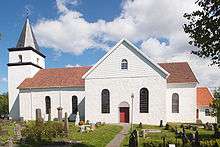
| Lista | Vanse Church | Vanse | c. 1037 |
| Vestbygda Chapel | Vestbygd | 1909 |
History
There is evidence of settlement in Farsund and Lista since the Stone Age.
Farsund held a strategic location in the Atlantic wall during World War II, with the Lundebanen and over 400 bunkers built in Farsund municipality, many that can be visited. Between 1940–1945, large Soviet prison camps were located at Lista, with prison camps at Kåde and Ore holding over 600 prisoners. The Soviet prisoners were used as forced labour to build Farsund Airport, bunkers, barracks, and fortifications .[8]
Farsund previously had a hospital, which was closed down in 2007.
Government
All municipalities in Norway, including Farsund, are responsible for primary education (through 10th grade), outpatient health services, senior citizen services, unemployment and other social services, zoning, economic development, and municipal roads. The municipality is governed by a municipal council of elected representatives, which in turn elect a mayor.
Municipal council
The municipal council (Kommunestyre) of Farsund is made up of 29 representatives that are elected to four year terms. Currently, the party breakdown is as follows:[9]
| Party Name (in Norwegian) | Number of representatives | |
|---|---|---|
| Labour Party (Arbeiderpartiet) | 6 | |
| Progress Party (Fremskrittspartiet) | 6 | |
| Conservative Party (Høyre) | 6 | |
| Christian Democratic Party (Kristelig Folkeparti) | 5 | |
| Pensioners' Party (Pensjonistpartiet) | 1 | |
| Centre Party (Senterpartiet) | 2 | |
| Socialist Left Party (Sosialistisk Venstreparti) | 1 | |
| Liberal Party (Venstre) | 2 | |
| Total number of members: | 29 | |
Economy
The largest industries are Alcoa Lista, an aluminium plant, and Farsund Aluminium Casting AS, which makes auto parts out of aluminium. Historically, shipping and fisheries have also been important. Farsund is the largest agricultural district in the county of Vest-Agder, having 26 square kilometres (10 sq mi) productive land, 88 square kilometres (34 sq mi) of forest, and 11 square kilometres (4.2 sq mi) freshwater areas. Farsund was already organized as a trading centre in 1795, and in 1995 celebrated its 200-year jubilee.
Trade and shipping laid the foundation for prosperity, and "the city of the strait" was a period one of the world's largest shipping towns in relation to the size of population.
Geography
The municipality sits in southwestern Norway along the North Sea. The Fedafjorden and Listafjorden lie along the northwestern side of the municipality and the Lyngdalsfjorden lies in the eastern part of Farsund. The coastal municipality has two lighthouses: Lista Lighthouse in the west and Søndre Katland Lighthouse in the south.
Climate
| Climate data for Lista Lighthouse | |||||||||||||
|---|---|---|---|---|---|---|---|---|---|---|---|---|---|
| Month | Jan | Feb | Mar | Apr | May | Jun | Jul | Aug | Sep | Oct | Nov | Dec | Year |
| Average high °C (°F) | 2.8 (37.0) |
2.6 (36.7) |
4.2 (39.6) |
7.5 (45.5) |
12.0 (53.6) |
14.9 (58.8) |
16.3 (61.3) |
16.9 (62.4) |
14.3 (57.7) |
11.2 (52.2) |
7.4 (45.3) |
4.7 (40.5) |
9.6 (49.3) |
| Daily mean °C (°F) | 1.0 (33.8) |
0.5 (32.9) |
2.2 (36.0) |
4.9 (40.8) |
9.2 (48.6) |
12.4 (54.3) |
13.9 (57.0) |
14.6 (58.3) |
12.2 (54.0) |
9.4 (48.9) |
5.5 (41.9) |
2.7 (36.9) |
7.4 (45.3) |
| Average low °C (°F) | −1.2 (29.8) |
−1.7 (28.9) |
0.1 (32.2) |
2.5 (36.5) |
6.8 (44.2) |
10.0 (50.0) |
11.8 (53.2) |
12.3 (54.1) |
10.2 (50.4) |
7.3 (45.1) |
3.3 (37.9) |
0.4 (32.7) |
5.2 (41.4) |
| Average precipitation mm (inches) | 94 (3.7) |
61 (2.4) |
74 (2.9) |
58 (2.3) |
72 (2.8) |
67 (2.6) |
78 (3.1) |
107 (4.2) |
134 (5.3) |
151 (5.9) |
150 (5.9) |
101 (4.0) |
1,147 (45.2) |
| Average precipitation days (≥ 1 mm) | 13.2 | 8.8 | 11.1 | 9.1 | 9.7 | 9.0 | 9.2 | 11.5 | 14.8 | 15.7 | 16.9 | 13.6 | 142.6 |
| Source: Norwegian Meteorological Institute[10] | |||||||||||||
Farsund Airport
Farsund Airport, Lista (FAN) was closed in 2002. The airport had from 1955 to 2002 scheduled traffic to Stavanger, Bergen and Oslo. Airlines which have frequented at Lista are among others Braathens SAFE, Norving and Air Stord.
The Airport was built by Luftwaffe in 1940, and they operated the airport with several fighter squadrons during World War II.[11] After the war, the Royal Norwegian Air Force took over the airport, and for a period it was used as training camp for conscripts.
Today, the airport is privatized and is an industrial area with only minor GA-traffic.
Education
Farsund has 3 primary schools, located in Farsund, Vanse, and Borhaug. Furthermore, there are two junior high schools, in Farsund and Vanse, and two high schools also located in Farsund and Vanse.
Outdoor Activities
- Farsund is a town linked to the fjords. Its guest harbour was considered one of the best in Norway, and is full of boats in summer months.
- Every year, Strandmila (5k / 10k run) takes place in Husenby Park. The course covers countryside trails, forest paths and sand beaches.
- The annual Kaperdagene (Pirate Town) festival takes place in July and depicts a battle between British and Norwegian ships who were fighting a war against pirates in the 1800s. It has been running since 1996.
- The American Festival (Last weekend in June) is considered one of the most popular festivals in the region. It takes place, as mention in their name, in the last weekend in June in Vanse. And it celebrates the American heritage that many families from Lista brought home with them from the Unites States in the late 60s and early 70s. It is celebrated with an American inspired parade and also an old Am-Car Parade.
Twin towns
Farsund is twinned with:
References
- "Navn på steder og personer: Innbyggjarnamn" (in Norwegian). Språkrådet.
- "Forskrift om målvedtak i kommunar og fylkeskommunar" (in Norwegian). Lovdata.no.
- Statistisk sentralbyrå (2017). "Table: 06913: Population 1 January and population changes during the calendar year (M)" (in Norwegian). Retrieved 2017-11-04.
- Statistisk sentralbyrå (1 January 2015). "Urban settlements. Population and area, by municipality".
- Jukvam, Dag (1999). "Historisk oversikt over endringer i kommune- og fylkesinndelingen" (PDF) (in Norwegian). Statistisk sentralbyrå.
- Rygh, Oluf (1912). Norske gaardnavne: Lister og Mandals amt (in Norwegian) (9 ed.). Kristiania, Norge: W. C. Fabritius & sønners bogtrikkeri. p. 182.
- "Civic heraldry of Norway - Norske Kommunevåpen". Heraldry of the World. Retrieved 2016-09-13.
- "Sovjetiske krigsfanger" (PDF).
- "Table: 04813: Members of the local councils, by party/electoral list at the Municipal Council election (M)" (in Norwegian). Statistics Norway. 2015.
- "eKlima Web Portal". Norwegian Meteorological Institute. Archived from the original on 2004-06-14.
- "Norske Flyplasser". Archived from the original on 2017-10-13. Retrieved 2012-12-02.
External links


- Municipal fact sheet from Statistics Norway (in Norwegian)
- Some Photographs of Farsund in August 1986, including the Torvestuene
- Farsund Kommune
 |  | ||||||||||||||||||||
|