Farm to Market Road 2919
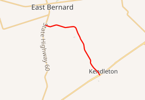
Farm to Market Road 2919 (FM 2919) is a state highway in the U.S. state of Texas. The two-lane highway begins at State Highway 60 (SH 60) in East Bernard within Wharton County, heads in a generally southeasterly direction, and ends at Future Interstate 69/U.S. Route 59 (Future I-69/US 59) in Kendleton within Fort Bend County.
| ||||
|---|---|---|---|---|

| ||||
| Route information | ||||
| Maintained by TxDOT | ||||
| Length | 7.095 mi[1] (11.418 km) | |||
| Existed | May 6, 1964[1]–present | |||
| Major junctions | ||||
| West end | ||||
| East end | ||||
| Location | ||||
| Counties | Fort Bend, Wharton | |||
| Highway system | ||||
| ||||
Route description
A two-lane road, FM 2919 starts at a stop sign on SH 60 at the southern edge of East Bernard in Wharton County and heads in an easterly direction for about 2.4 miles (3.9 km). After veering to the southeast for another 0.8 miles (1.3 km) the highway crosses the San Bernard River and enters Fort Bend County near the Bay Ridge Christian College. From the river to the tiny community of Powell Point is 1.1 miles (1.8 km). FM 2919 continues to the southeast for another 2.7 miles (4.3 km) to Loop 541 and the Union Pacific Railroad in Kendleton. From Loop 541 to the Future I-69/US 59 feeder road and overpass is a short block.[2]
- View east on FM 2919 near Highway 60 in East Bernard
- FM 2919 bridge over the San Bernard River
- View northwest at FM 2919 and Loop 541 junction
History
FM 2919 was originally designated on May 6, 1964, to begin at US 90A in Kendleton in Fort Bend County, go about 3.8 miles (6.1 km) to the northwest and end at the San Bernard River. On January 18, 1967, a 3.5 miles (5.6 km) section of FM 1164 between SH 60 and the San Bernard River in Wharton County was transferred to FM 2919. On June 21, 1977, FM 2919 was extended about 0.1 miles (0.16 km) southeast from what is now Future I-69/US 59 to the proposed Future I-69/US 59.[1]
- Historical marker at Powell Point on FM 2919
- View of Kendleton from the northwest on FM 2919
- Nearby marker explains Terry v. Adams civil rights case
Major intersections
| County | Location | mi | km | Destinations | Notes |
|---|---|---|---|---|---|
| Wharton | East Bernard | 0.0 | 0.0 | Western terminus of FM 2919 | |
| Fort Bend | Kendleton | 7.0 | 11.3 | ||
| 7.1 | 11.4 | I-69/US 59 exit 87; eastern terminus of FM 2919; U.S. 59 is the future Interstate 69 | |||
| 1.000 mi = 1.609 km; 1.000 km = 0.621 mi | |||||
See also


References
- Transportation Planning and Programming Division (n.d.). "Farm to Market Road No. 2919". Highway Designation Files. Texas Department of Transportation. Retrieved May 7, 2013.
- Google (May 7, 2013). "Farm to Market Road 2919" (Map). Google Maps. Google. Retrieved May 7, 2013.
