Farm to Market Road 2918
Farm to Market Road 2918 (FM 2918) is a farm to market road in Brazoria County, Texas.[1]
| ||||
|---|---|---|---|---|
| ||||
| Route information | ||||
| Length | 9.743 mi[1] (15.680 km) | |||
| Major junctions | ||||
| South end | Dead end at the Intracoastal Waterway | |||
| North end | ||||
| Location | ||||
| Counties | Brazoria | |||
| Highway system | ||||
| ||||

Route description
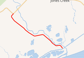
FM 2918 begins at a boat ramp at the Intracoastal Waterway. The two-lane road travels to the northwest, roughly paralleling the San Bernard River and providing access to riverfront communities. The San Bernard National Wildlife Refuge lies along the south side of the road. The route ends at an intersection with FM 2611 near the community of Churchill.[1][2]
History
FM 2918 was commissioned on May 6, 1964, from FM 2611 to the community of McNeel. The extension to the Intracoastal Waterway was designated on June 1, 1965.[1]
Major intersections
The entire route is in Brazoria County.
| Location | mi[3] | km | Destinations | Notes | |
|---|---|---|---|---|---|
| Rivers End | 0.0 | 0.0 | Intracoastal Waterway | Southern terminus | |
| | 9.8 | 15.8 | Northern terminus | ||
| 1.000 mi = 1.609 km; 1.000 km = 0.621 mi | |||||
gollark: In any case, those permissions are irrevocable under P³ clause [REDACTED].
gollark: osmarks.tk will not *die* unless freenom does so. It may, however, be superseded and be a redirect.
gollark: I also plan to obtain osmarksVPS™ with baidicoot, so we can have an independent status panel.
gollark: That wouldn't even make sense, it would be pointed at the same servers.
gollark: No.
References
- Transportation Planning and Programming Division (n.d.). "Farm to Market Road No. 2918". Highway Designation Files. Texas Department of Transportation. Retrieved 2011-01-06.
- Transportation Planning and Programming Division (2012). Texas County Mapbook (PDF) (Map) (2012 ed.). 1:120,000. Texas Department of Transportation. p. 565. OCLC 867856197. Retrieved 2011-01-06.
- Google (2011-01-06). "Overview map of Farm to Market Road 2918 Distances Between Interchanges" (Map). Google Maps. Google. Retrieved 2011-01-06.
This article is issued from Wikipedia. The text is licensed under Creative Commons - Attribution - Sharealike. Additional terms may apply for the media files.