Farbus Mountain
Farbus Mountain is located on the provincial border of Alberta and British Columbia in Banff National Park. It was named in 1918 after Farbus, a village on the eastern slopes of Vimy Ridge in France.[1][2]In the Battle of Vimy Ridge, Canadian troops retook Farbus from German control on April 9, 1917 as part of securing the Brown Line objective.[4][5]
| Farbus Mountain | |
|---|---|
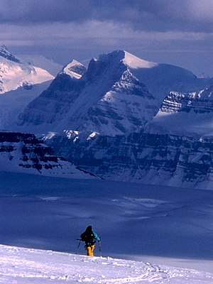 Farbus Mtn. (left) from the Columbia Icefield | |
| Highest point | |
| Elevation | 3,205 m (10,515 ft) [1] |
| Prominence | 205 m (673 ft) [2] |
| Parent peak | Mount Lyell 3498 m[2] |
| Listing | Mountains of Alberta |
| Coordinates | 51°57′57″N 117°07′54″W [3] |
| Geography | |
 Farbus Mountain Location in Alberta and British Columbia  Farbus Mountain Farbus Mountain (British Columbia) | |
| Country | Canada |
| Provinces | Alberta and British Columbia |
| National Park | Banff |
| Parent range | Continental Ranges[2] |
| Topo map | NTS 82N/14 |
| Climbing | |
| First ascent | 1937 S.B. Hendricks, Rex Gibson[2] |
See also
- List of peaks on the British Columbia-Alberta border
- Mountains of British Columbia
References
- "Farbus Mountain". PeakFinder.com. Retrieved 2019-08-19.
- "Farbus Mountain". Bivouac.com. Retrieved 2019-08-19.
- "Farbus Mountain". Geographical Names Data Base. Natural Resources Canada. Retrieved 2019-08-19.
- "Capture of the 590". Albert County Museum. Retrieved 2019-08-19.
- "The Battle of Vimy Ridge: April 9 - 12, 1917". Library and Archives Canada. Government of Canada. Retrieved 2019-08-19.
This article is issued from Wikipedia. The text is licensed under Creative Commons - Attribution - Sharealike. Additional terms may apply for the media files.