Essel
Essel is a municipality in the Heidekreis district, in Lower Saxony, Germany. Most of the village is located on the southern bank of the river Aller. The A 7 motorway runs through the village.
Essel | |
|---|---|
 Coat of arms | |
Location of Essel within Heidekreis district 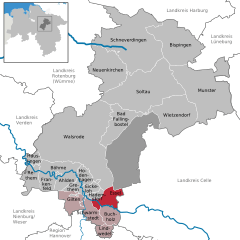  | |
 Essel  Essel | |
| Coordinates: 52°41′22″N 9°38′37″E | |
| Country | Germany |
| State | Lower Saxony |
| District | Heidekreis |
| Municipal assoc. | Schwarmstedt |
| Subdivisions | 4 Ortschaften |
| Government | |
| • Mayor | Bernd Block (CDU) |
| Area | |
| • Total | 34.06 km2 (13.15 sq mi) |
| Elevation | 27 m (89 ft) |
| Population (2018-12-31)[1] | |
| • Total | 1,149 |
| • Density | 34/km2 (87/sq mi) |
| Time zone | CET/CEST (UTC+1/+2) |
| Postal codes | 29690 |
| Dialling codes | 0 50 71 |
| Vehicle registration | SFA |
| Website | www.essel.de |
Subdivisions
The municipality of Essel comprises 4 subdivisions:
- Essel
- Engehausen
- Stillenhöfen
- Ostenholz Moor
History
Essel was first mentioned in 1251 as Esele. The surveillance of the Aller crossing at Essel and control of Aller shipping was undertaken by the three lords of Hademstorf. In the 14th century their seat was at Uhlenburg. This castle was situated in the Aller valley between Essel and Buchholz (Aller) and was destroyed in 1394 by the Dukes of Brunswick-Lüneburg.
Another castle was built in the 13th century at Engehausen—Blankenburg Castle—on the site of which a manor house was subsequently built.
Towns and municipalities in Heidekreis | ||
|---|---|---|
Coat of arms | ||
gollark: Ads also come hand-in-hand with the adtech industry's stupid amount of data gathering generally, which I *also* attempt to block.
gollark: I just adblock basically everything. It saves my time, screen space and bandwidth and stops my brain from processing stuff tailored explicitly to make me buy stuff I probably don't actually need or would otherwise want.
gollark: To be fair, updating them *did* fix it, but still.
gollark: This is what happens when you do that.
gollark: I do sometimes have RAM issues when I've got no internet connection to download RAM, but I use tab *suspender* to make tabs I'm not actively using basically RAM-free!
References
| Authority control |
|
|---|
This article is issued from Wikipedia. The text is licensed under Creative Commons - Attribution - Sharealike. Additional terms may apply for the media files.