Schneverdingen
Schneverdingen (German pronunciation: [ˈʃneːvɐdɪŋən]; Low Saxon Snevern) is a town in the northern part of the district of Heidekreis, in Lower Saxony, Germany. It is located in the area known as Lüneburg Heath.
Schneverdingen | |
|---|---|
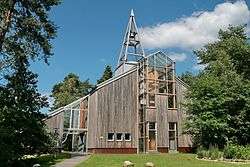 One World Church | |
 Coat of arms | |
Location of Schneverdingen within Heidekreis district 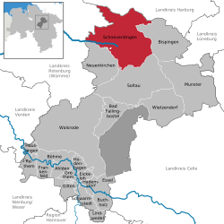 | |
 Schneverdingen 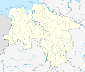 Schneverdingen | |
| Coordinates: 53°07′00″N 09°48′00″E | |
| Country | Germany |
| State | Lower Saxony |
| District | Heidekreis |
| Subdivisions | 10 districts |
| Government | |
| • Mayor | Meike Moog-Steffens (Ind.) |
| Area | |
| • Total | 234.58 km2 (90.57 sq mi) |
| Elevation | 97 m (318 ft) |
| Population (2018-12-31)[1] | |
| • Total | 18,662 |
| • Density | 80/km2 (210/sq mi) |
| Time zone | CET/CEST (UTC+1/+2) |
| Postal codes | 29640 |
| Dialling codes | 05193, -98, -99, 04265 |
| Vehicle registration | SFA/HK |
| Website | www.schneverdingen.de |
Geography
History
Schneverdingen belonged to the Prince-Bishopric of Verden, established in 1180. In 1648 the Prince-Bishopric was transformed into the Principality of Verden, which was first ruled in personal union by the Swedish Crown - interrupted by a Danish occupation (1712–1715) - and from 1715 on by the Hanoverian Crown. The Kingdom of Hanover incorporated the Principality in a real union and the Princely territory, including Schneverdingen, became part of the new Stade Region, established in 1823.
Places of interest
- Höpen Airfield
- Reinsehlen Camp
- Heidegarten
- Pietzmoor
gollark: What dißcord server?
gollark: Yes.
gollark: LyricLy = utter wavelength division multiplexing.
gollark: How about "legoids"?
gollark: Well, in that case, I shall refer to them as "legological cuboids".
External links
| Wikimedia Commons has media related to Schneverdingen. |
| Wikivoyage has a travel guide for Schneverdingen. |
Towns and municipalities in Heidekreis | ||
|---|---|---|
Coat of arms | ||
| Authority control |
|
|---|
This article is issued from Wikipedia. The text is licensed under Creative Commons - Attribution - Sharealike. Additional terms may apply for the media files.