Erula
Erula (Gallurese: Èrula, Sardinian: Èrula) is a comune (municipality) in the Province of Sassari in the Italian region Sardinia, located about 180 kilometres (110 mi) north of Cagliari and about 35 kilometres (22 mi) east of Sassari. As of 31 December 2004, it had a population of 807 and an area of 40.1 square kilometres (15.5 sq mi).[3]
Erula Èrula | |
|---|---|
| Comune di Erula | |
.jpg) | |
Location of Erula 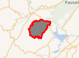
| |
 Erula Location of Erula in Sardinia  Erula Erula (Sardinia) | |
| Coordinates: 40°48′N 8°57′E | |
| Country | Italy |
| Region | Sardinia |
| Province | Province of Sassari (SS) |
| Frazioni | Sa Mela, Tettile |
| Area | |
| • Total | 40.1 km2 (15.5 sq mi) |
| Elevation | 457 m (1,499 ft) |
| Population (Dec. 2004)[2] | |
| • Total | 807 |
| • Density | 20/km2 (52/sq mi) |
| Demonym(s) | Erulesi |
| Time zone | UTC+1 (CET) |
| • Summer (DST) | UTC+2 (CEST) |
| Postal code | 07030 |
| Dialing code | 079 |
The municipality of Erula contains the frazioni (subdivisions, mainly villages and hamlets) Sa Mela and Tettile.
Erula borders the following municipalities: Chiaramonti, Ozieri, Perfugas, Tempio Pausania, Tula.
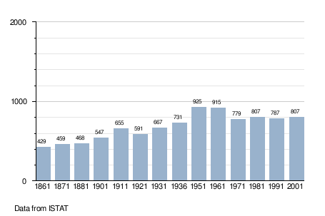
Demographic evolution
gollark: There are examples under the Display trait I think.
gollark: This is not surprising.
gollark: As far as I know most of our pathogens are quite old.
gollark: That seems impossible.
gollark: Tuesday 2™.
References
| Wikimedia Commons has media related to Erula. |
- "Superficie di Comuni Province e Regioni italiane al 9 ottobre 2011". Istat. Retrieved 16 March 2019.
- "Popolazione Residente al 1° Gennaio 2018". Istat. Retrieved 16 March 2019.
- All demographics and other statistics: Italian statistical institute Istat.

This article is issued from Wikipedia. The text is licensed under Creative Commons - Attribution - Sharealike. Additional terms may apply for the media files.