Erin Springs, Oklahoma
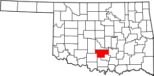
Erin Springs is a town in Garvin County, Oklahoma, United States. The population was 87 at the 2010 census, a decline of 23.7 percent from 114 at the 2000 census.[3]
Erin Springs, Oklahoma | |
|---|---|
Location of Erin Springs, Oklahoma | |
| Coordinates: 34°48′48″N 97°36′12″W | |
| Country | United States |
| State | Oklahoma |
| County | Garvin |
| Area | |
| • Total | 0.2 sq mi (0.4 km2) |
| • Land | 0.2 sq mi (0.4 km2) |
| • Water | 0.0 sq mi (0.0 km2) |
| Elevation | 994 ft (303 m) |
| Population (2010) | |
| • Total | 87 |
| • Density | 435/sq mi (217.5/km2) |
| Time zone | UTC-6 (Central (CST)) |
| • Summer (DST) | UTC-5 (CDT) |
| FIPS code | 40-24300[1] |
| GNIS feature ID | 1092635[2] |
History
The town began in 1871, when Frank Murray, an Irish immigrant from Londonderry, built a home at this location. He later became a large landowner and cattle rancher, owning 20,000 acres (8,100 ha) of land and 26,000 head of cattle. The community was initially known as Elm Springs, for a large elm tree that grew behind the stage depot.[4]
Elm Springs was renamed Erin Springs, in honor of Frank Murray's sister, Erin Westland.[4]
Geography
Erin Springs is located at 34°48′48″N 97°36′12″W (34.813220, -97.603462).[5]
According to the United States Census Bureau, the town has a total area of 0.2 square miles (0.52 km2), all of it land.
Demographics
As of the census of 2010, there were 87 people, 36 households, and 25 families residing in the town.[6] The population density was 435 people per square mile (217.5/km2). There were 41 housing units at an average density of 288.4 per square mile (111.3/km2). The racial makeup of the town was 88.5% White, 4.6% Native American, 1.1% from Asian, and 5.7% from two or more races.
There were 36 households, out of which 19.4% had children under the age of 18 living with them, 55.6% were married couples living together, 8.3% had a female householder with no husband present, and 30.6% were non-families. A quarter of the households (25%) were made up of individuals, and 16.7% had someone living alone who was 65 years of age or older. The average household size was 2.42 and the average family size was 2.88.
In the town, the population was spread out, with 26.3% under the age of 18, 6.1% from 18 to 24, 21.9% from 25 to 44, 26.3% from 45 to 64, and 17.2% who were 65 years of age or older. The median age was 41.5 years. For every 100 females, there were 83.9 males. For every 100 females age 18 and over, there were 82.6 males.
The median income for a household in the town was $43,125, and the median income for a family was $18,929.[7] Males had a median income of $65,875 versus $14,883 for females. The per capita income for the town was $25,600. Almost half (46.3%) of the population and 47.8% of families were below the poverty line.
References
- "U.S. Census website". United States Census Bureau. Retrieved 2008-01-31.
- "US Board on Geographic Names". United States Geological Survey. 2007-10-25. Retrieved 2008-01-31.
- CensusViewer:Erin Springs, Oklahoma Population. Retrieved December 2, 2013.
- Oklahoma GenWeb. "Erin Springs." Retrieved December 1, 2013.
- "US Gazetteer files: 2010, 2000, and 1990". United States Census Bureau. 2011-02-12. Retrieved 2011-04-23.
- United States Census. 2010 Demographic Profile Data, AmericanFactFinder. (accessed December 2, 2013)
- 2007-2011 American Community Survey 5-Year Estimates, United States Census Bureau. (accessed December 2, 2013)
