Elizaville, Kentucky
Elizaville is a census-designated place and unincorporated community in Fleming County, Kentucky, United States. Its population was 181 as of the 2010 census.[2] Elizaville is located at the junction of Kentucky Route 32 and Kentucky Route 170, 5 miles (8.0 km) west of Flemingsburg.[4] Elizaville has a post office with ZIP code 41037.[5][6]
Elizaville, Kentucky | |
|---|---|
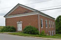
 The former Elizaville Presbyterian Church | |
 Elizaville | |
| Coordinates: 38°25′10″N 83°49′32″W | |
| Country | United States |
| State | Kentucky |
| County | Fleming |
| Area | |
| • Total | 1.028 sq mi (2.66 km2) |
| • Land | 1.026 sq mi (2.66 km2) |
| • Water | 0.002 sq mi (0.005 km2) |
| Elevation | 886 ft (270 m) |
| Population (2010)[2] | |
| • Total | 181 |
| • Density | 180/sq mi (68/km2) |
| Time zone | UTC-5 (Eastern (EST)) |
| • Summer (DST) | UTC-4 (EDT) |
| ZIP code | 41037 |
| Area code(s) | 606 |
| GNIS feature ID | 491643[3] |
History
A post office was established in Elizaville in 1819.[7] The community has the name of a daughter of an early citizen.[8]
Historic sites in Elizaville include the Elizaville Presbyterian Church and Elizaville Cemetery.
gollark: As planned.
gollark: Nanomachines are OC hardware, so they can receive OC messages.
gollark: I would not.
gollark: I would be surprised if CC couldn't operate nanomachines via a relay.
gollark: I have Skynet for this. Also SPUDNET.
References
- "US Gazetteer files: 2010, 2000, and 1990". United States Census Bureau. 2011-02-12. Retrieved 2011-04-23.
- "U.S. Census website". United States Census Bureau. Retrieved 2011-05-14.
- "Elizaville". Geographic Names Information System. United States Geological Survey.
- State Primary Road System: Fleming County (PDF) (Map). Kentucky Transportation Cabinet. 2011. Retrieved December 21, 2012.
- "Postmaster Finder - Post Offices by ZIP Code". United States Postal Service. Retrieved December 21, 2012.
- United States Postal Service (2012). "USPS - Look Up a ZIP Code". Retrieved 2012-02-15.
- "Fleming County". Jim Forte Postal History. Archived from the original on 4 January 2015. Retrieved 4 January 2015.
- Rennick, Robert M. (1987). Kentucky Place Names. University Press of Kentucky. p. 91. ISBN 0813126312. Retrieved 2013-04-28.
This article is issued from Wikipedia. The text is licensed under Creative Commons - Attribution - Sharealike. Additional terms may apply for the media files.
