Hillsboro, Kentucky
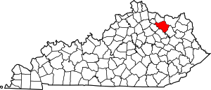
Hillsboro is an unincorporated community in Fleming County, Kentucky, United States. Hillsboro is located at the junction of Kentucky Route 111 and Kentucky Route 158, 9.8 miles (15.8 km) south-southeast of Flemingsburg.[4]
Hillsboro, Kentucky | |
|---|---|
Unincorporated community | |
 Hillsboro | |
| Coordinates: 38°17′36″N 83°39′32″W | |
| Country | United States |
| State | Kentucky |
| County | Fleming |
| Elevation | 863 ft (263 m) |
| Population (2000) | |
| • Total | 2,010 [1] |
| Time zone | UTC-5 (Eastern (EST)) |
| • Summer (DST) | UTC-4 (EDT) |
| ZIP code | 41049[2] |
| Area code(s) | 606 |
| GNIS feature ID | 494271[3] |
History
First called Foudraysville for the Foudray family of early settlers, it was renamed Hillsboro when the post office opened in 1833.[5]
Hillsboro Covered Bridge, which is listed on the National Register of Historic Places, is located in Hillsboro.[6]
gollark: But because of your gating/nerfing, the nether is required for... everything or so?
gollark: Yes, there is a mismatch of play styles, I suppose.
gollark: I would probably join if it wasn't so combat-based and nerfy and I could actually reliably run it.
gollark: Unfortunately it also includes fishing now.
gollark: There's a TE enchanted whatever augment now.
References
- Zipcode.org (2007). "Hillsboro, Kentucky". Retrieved 5/7/2019. Check date values in:
|accessdate=(help) - United States Postal Service (2012). "USPS - Look Up a ZIP Code". Retrieved 2012-02-15.
- "Hillsboro". Geographic Names Information System. United States Geological Survey.
- State Primary Road System: Fleming County (PDF) (Map). Kentucky Transportation Cabinet. 2011. Retrieved March 26, 2013.
- Rennick, Robert M. (1987). Kentucky Place Names. University Press of Kentucky. p. 141. ISBN 0813126312. Retrieved 2013-04-28.
- "National Register Information System". National Register of Historic Places. National Park Service. July 9, 2010.
This article is issued from Wikipedia. The text is licensed under Creative Commons - Attribution - Sharealike. Additional terms may apply for the media files.
