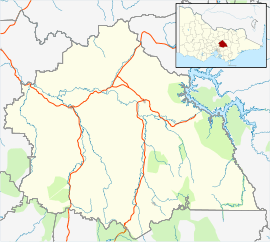
Eildon, Victoria
Eildon is a town in Victoria, Australia. It is located near Lake Eildon, on the Goulburn Valley Highway, in the Shire of Murrindindi local government area. At the 2016 Census, Eildon had a population of 974.[1]
| Eildon Victoria | |
|---|---|
 Eildon | |
| Coordinates | 37°14′0″S 145°55′0″E |
| Population | 974 (2016 census)[1] |
| Postcode(s) | 3713 |
| Elevation | 232 m (761 ft) |
| Location | |
| LGA(s) | Shire of Murrindindi |
| State electorate(s) | Eildon |
| Federal Division(s) | Indi |
History
A Post Office named Eildon opened on 14 November 1890 and closed in 1893. Later a Post Office named Eildon Weir opened on 23 August 1915 and was renamed Eildon in about 1950.[2]
The township was relocated to its present position when the new dam was built in the 1950s.
Climate
| Climate data for Lake Eildon, 1981-2010 | |||||||||||||
|---|---|---|---|---|---|---|---|---|---|---|---|---|---|
| Month | Jan | Feb | Mar | Apr | May | Jun | Jul | Aug | Sep | Oct | Nov | Dec | Year |
| Record high °C (°F) | 43.0 (109.4) |
45.4 (113.7) |
39.1 (102.4) |
34.1 (93.4) |
26.9 (80.4) |
20.5 (68.9) |
21.0 (69.8) |
24.5 (76.1) |
28.5 (83.3) |
34.2 (93.6) |
38.9 (102.0) |
40.4 (104.7) |
45.4 (113.7) |
| Average high °C (°F) | 29.0 (84.2) |
29.1 (84.4) |
25.9 (78.6) |
21.1 (70.0) |
16.3 (61.3) |
12.7 (54.9) |
12.0 (53.6) |
13.8 (56.8) |
16.7 (62.1) |
20.0 (68.0) |
23.7 (74.7) |
26.2 (79.2) |
20.5 (68.9) |
| Daily mean °C (°F) | 20.8 (69.4) |
20.9 (69.6) |
18.2 (64.8) |
14.5 (58.1) |
11.2 (52.2) |
8.5 (47.3) |
7.8 (46.0) |
9.0 (48.2) |
11.2 (52.2) |
13.6 (56.5) |
16.6 (61.9) |
18.6 (65.5) |
14.2 (57.6) |
| Average low °C (°F) | 12.6 (54.7) |
12.6 (54.7) |
10.5 (50.9) |
7.8 (46.0) |
6.0 (42.8) |
4.2 (39.6) |
3.5 (38.3) |
4.2 (39.6) |
5.6 (42.1) |
7.2 (45.0) |
9.5 (49.1) |
10.9 (51.6) |
7.9 (46.2) |
| Record low °C (°F) | 2.8 (37.0) |
3.2 (37.8) |
2.1 (35.8) |
0.0 (32.0) |
−1.8 (28.8) |
−3.6 (25.5) |
−4.3 (24.3) |
−4.1 (24.6) |
−1.8 (28.8) |
−1.1 (30.0) |
0.7 (33.3) |
2.1 (35.8) |
−4.3 (24.3) |
| Average precipitation mm (inches) | 51.8 (2.04) |
39.8 (1.57) |
41.1 (1.62) |
52.4 (2.06) |
73.5 (2.89) |
90.1 (3.55) |
93.5 (3.68) |
106.8 (4.20) |
88.3 (3.48) |
73.1 (2.88) |
70.0 (2.76) |
62.1 (2.44) |
843.0 (33.19) |
| Average precipitation days (≥ 0.2mm) | 6.8 | 5.6 | 6.5 | 8.8 | 12.6 | 15.9 | 17.2 | 17.7 | 14.9 | 12.2 | 10.1 | 8.4 | 136.7 |
| Mean monthly sunshine hours | 269.7 | 245.8 | 226.3 | 177.0 | 108.5 | 69.0 | 77.5 | 114.7 | 156.0 | 220.1 | 234.0 | 244.9 | 2,143.5 |
| Source: [3] | |||||||||||||
Recreation
The lake that shares its name with the town is used for water sports and camping.
Together with its neighbouring township Thornton, Eildon has an Australian Rules football team (Thornton-Eildon) competing in the Yarra Valley Mountain District Football League.[4]
Golfers play at the course of the Eildon Golf Club on Jamieson Road.[5]
The International Tennis Centre, Located near the banks of the upper Pondage is open year-round.
Points of Interest
- Eildon Trout Farm - This trout farm is located on the banks of the Goulburn River.
- Snobs Creek Falls - Snobs Creek Falls (also known as just Snobs Falls) is a reliably flowing waterfall. The falls have a drop of 100m.
See also
References
- Australian Bureau of Statistics (27 June 2017). "Eildon (State Suburb)". 2016 Census QuickStats. Retrieved 8 August 2017.

- Premier Postal History, Post Office List, retrieved 11 April 2008
- "Climate statistics for Lake Eildon, 1981-2010 (Extremes 1970-2017)". Bureau of Meteorology. Retrieved 30 November 2017.
- Full Points Footy, Yarra Valley Mountain District, archived from the original on 24 July 2008, retrieved 25 July 2008
- Golf Select, Eildon, retrieved 11 May 2009