Edwards, Colorado
Edwards is an unincorporated community and census-designated place (CDP) in Eagle County, Colorado, United States. Edwards is the principal community of the Edwards Micropolitan Statistical Area. The population was 10,266 at the 2010 census,[3][4] up from 8,257 at the 2000 census. The Edwards Post Office has the ZIP code 81632.[2]
Edwards, Colorado | |
|---|---|
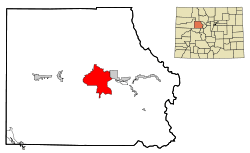 Location in Eagle County and the state of Colorado | |
| Coordinates: 39°38′25″N 106°35′32″W | |
| Country | |
| State | |
| County | Eagle[1] |
| Area | |
| • Total | 26.8 sq mi (69.4 km2) |
| • Land | 26.6 sq mi (69.0 km2) |
| • Water | 0.2 sq mi (0.4 km2) |
| Elevation | 7,221 ft (2,201 m) |
| Population (2010) | |
| • Total | 10,266 |
| • Density | 385/sq mi (148.8/km2) |
| Time zone | UTC-7 (MST) |
| • Summer (DST) | UTC-6 (MDT) |
| ZIP code[2] | 81632 |
| Area code(s) | 970 |
| FIPS code | 08-23300 |
| GNIS feature ID | 0204666 |
A post office called Edwards has been in operation since 1883.[5] The community was named after Melvin Edwards, a local postal official.[6]
Geography
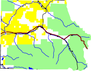 Edwards is in the center of Eagle County, on I-70. |
Edwards is located in central Eagle County at 39°38′25″N 106°35′32″W (39.640178, −106.592325).[7] It is in the valley of the Eagle River and extends southwards up the valleys of Lake Creek and Squaw Creek, at the north end of the Sawatch Range. It is bordered to the west by the town of Avon. U.S. Route 6 runs through the center of Edwards on the south side of the Eagle River, while Interstate 70 runs through the CDP north of the river, with access from Exit 163. Via I-70, it is 14 miles (23 km) east to Vail, 110 miles (180 km) east to Denver, 17 miles (27 km) west to Eagle, and 47 miles (76 km) west to Glenwood Springs.
According to the United States Census Bureau, the Edwards CDP has a total area of 26.8 square miles (69.4 km2), of which 26.6 square miles (69.0 km2) is land and 0.15 square miles (0.4 km2), or 0.57%, is water.[8]
Demographics
| Historical population | |||
|---|---|---|---|
| Census | Pop. | %± | |
| U.S. Decennial Census[9] | |||
As of the census[4] of 2000, there were 8,257 people, 2,852 households, and 1,888 families residing in the CDP. The population density was 207.9 people per square mile (80.3/km2). There were 3,953 housing units at an average density of 99.6 per square mile (38.4/km2). The racial makeup of the CDP was 82.39% White, 0.34% African American, 0.40% Native American, 0.82% Asian, 0.05% Pacific Islander, 14.56% from other races, and 1.44% from two or more races. Hispanic or Latino of any race were 27.24% of the population. There are a number of Jews in the population.[10][11]
There were 2,852 households, out of which 36.8% had children under the age of 18 living with them, 56.4% were married couples living together, 5.8% had a female householder with no husband present, and 33.8% were non-families. 18.2% of all households were made up of individuals, and 1.2% had someone living alone who was 65 years of age or older. The average household size was 2.89 and the average family size was 3.24.
In the CDP, the population was spread out, with 25.4% under the age of 18, 9.9% from 18 to 24, 40.4% from 25 to 44, 21.4% from 45 to 64, and 2.8% who were 65 years of age or older. The median age was 32 years. For every 100 females, there were 116.5 males. For every 100 females age 18 and over, there were 122.1 males.
The median income for a household in the CDP was $70,869, and the median income for a family was $83,887. Males had a median income of $42,009 versus $31,377 for females. The per capita income for the CDP was $39,784. About 2.9% of families and 6.8% of the population were below the poverty line, including 6.0% of those under age 18 and none of those age 65 or over.
Ski resorts
Edwards is in a favorable location for skiers and riders. Beaver Creek Resort is 4 miles (6 km) to the east while Vail is 14.5 miles (23.3 km) to the east.
See also
- Outline of Colorado
- State of Colorado
- Colorado cities and towns
- Colorado census designated places
- Colorado counties
- Colorado metropolitan areas
- Colorado cities and towns
References
- "US Board on Geographic Names". United States Geological Survey. 2007-10-25. Retrieved 2008-01-31.
- "ZIP Code Lookup". United States Postal Service. December 14, 2006. Archived from the original (JavaScript/HTML) on January 1, 2008. Retrieved December 14, 2006.
- Colorado Trend Report 2: State and Complete Places (Sub-state 2010 Census Data). Archived 2012-07-11 at Archive.today Missouri Census Data Center. Accessed 2011-02-25.
- "U.S. Census website". United States Census Bureau. Retrieved 2008-01-31.
- "Post offices". Jim Forte Postal History. Archived from the original on 6 March 2016. Retrieved 25 June 2016.
- Dawson, John Frank. Place names in Colorado: why 700 communities were so named, 150 of Spanish or Indian origin. Denver, CO: The J. Frank Dawson Publishing Co. p. 19.
- "US Gazetteer files: 2010, 2000, and 1990". United States Census Bureau. 2011-02-12. Retrieved 2011-04-23.
- "Geographic Identifiers: 2010 Demographic Profile Data (G001): Edwards CDP, Colorado". American Factfinder. U.S. Census Bureau. Archived from the original on February 13, 2020. Retrieved January 25, 2016.
- "Census of Population and Housing". Census.gov. Retrieved June 4, 2016.
- "'Medicine and Morals' class coming to Edwards". Vail Daily. February 10, 2011.
- "'Kabbalah of You' course offered in Edwards". Vail, CO Colorado. Vail Daily. October 25, 2012.
External links
- www.EdwardsColorado.com - Restaurants, Real Estate, Weather, Map, Population, Zip Code
- Current Information, Calendar of Events and Coupons For The Edwards Area
Municipalities and communities of Eagle County, Colorado, United States | ||
|---|---|---|
| Towns | 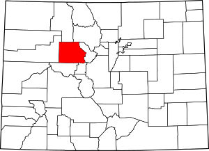 Map of Colorado highlighting Eagle County | |
| CDPs | ||
| Unincorporated communities | ||
| Ghost towns | ||
| Footnotes | ‡This populated place also has portions in an adjacent county or counties | |