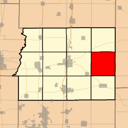
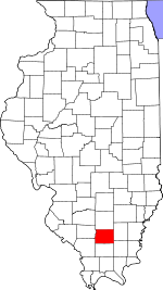
Eastern Township, Franklin County, Illinois
Eastern Township is one of twelve townships in Franklin County, Illinois, USA. As of the 2010 census, its population was 582 and it contained 267 housing units.[2]
Eastern Township | |
|---|---|
 Location in Franklin County | |
 Franklin County's location in Illinois | |
| Coordinates: 37°59′47″N 88°45′40″W | |
| Country | United States |
| State | Illinois |
| County | Franklin |
| Established | November 4, 1884 |
| Area | |
| • Total | 36.22 sq mi (93.8 km2) |
| • Land | 36.13 sq mi (93.6 km2) |
| • Water | 0.09 sq mi (0.2 km2) 0.25% |
| Elevation | 453 ft (138 m) |
| Population (2010) | |
| • Estimate (2016)[1] | 564 |
| • Density | 16.1/sq mi (6.2/km2) |
| Time zone | UTC-6 (CST) |
| • Summer (DST) | UTC-5 (CDT) |
| ZIP codes | 62812, 62860, 62890 |
| FIPS code | 17-055-21735 |
Geography
According to the 2010 census, the township has a total area of 36.22 square miles (93.8 km2), of which 36.13 square miles (93.6 km2) (or 99.75%) is land and 0.09 square miles (0.23 km2) (or 0.25%) is water.[2]
Unincorporated towns
- Akin
- Akin Junction
- Bessie
- Boothby
- Rust
(This list is based on USGS data and may include former settlements.)
Cemeteries
The township contains these five cemeteries: Brady, Cook, Jones, Manion and Otterson.
Major highways
School districts
- Hamilton County Community Unit School District 10
Political districts
- Illinois' 12th congressional district
- State House District 117
- State Senate District 59
gollark: That would actually be more convenient for me during most of my phone use, though it would be a bit weird.
gollark: Or have four sets of ports, one on each side.There are so many possibilities other than boring generic "top or bottom".
gollark: Or just get rid of all ports and have it be wireless.
gollark: Well, except in that case you might as well hold the phone upside down and have both on the bottom.
gollark: Or both ports on top, even.
References
- "Eastern Township, Franklin County, Illinois". Geographic Names Information System. United States Geological Survey. Retrieved 2010-01-16.
- United States Census Bureau 2007 TIGER/Line Shapefiles
- United States National Atlas
- "Population and Housing Unit Estimates". Retrieved June 9, 2017.
- "Population, Housing Units, Area, and Density: 2010 - County -- County Subdivision and Place -- 2010 Census Summary File 1". United States Census. Archived from the original on 2020-02-12. Retrieved 2013-05-28.
- "Census of Population and Housing". Census.gov. Retrieved June 4, 2016.
External links
This article is issued from Wikipedia. The text is licensed under Creative Commons - Attribution - Sharealike. Additional terms may apply for the media files.