East Tisted
East Tisted (/ˈtaɪstɛd/) is a village and civil parish in the East Hampshire district of Hampshire, England. It is 4.8 miles (7.7 km) south of Alton on the A32 road.
| East Tisted | |
|---|---|
.jpg) Village pond at East Tisted | |
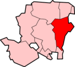
 East Tisted Location within Hampshire | |
| Population | 221 [1] 209 (2011 Census)[2] |
| OS grid reference | SU701322 |
| Civil parish |
|
| District | |
| Shire county | |
| Region | |
| Country | England |
| Sovereign state | United Kingdom |
| Post town | Alton |
| Postcode district | GU34 |
| Police | Hampshire |
| Fire | Hampshire |
| Ambulance | South Central |
| UK Parliament | |
The village lies 50 miles south-west of London, 14 miles east of the city of Winchester, 3.5 miles north-east of the village of West Tisted, 2.5 miles west of the village of Selborne, and 1.5 miles west of the village of Newton Valence. It has a population of about 200, residing in about 100 households.
History
The manor of East Tisted dates back to the 13th century when it was granted by the Crown to Adam de Gurdon. The manor passed by inheritance to the Norton family. In 1644, the manor and estates were seized by the Commonwealth from the Norton family as Sir Richard Norton was a supporter of the Royalist cause: the family regained the estates in 1661, after the Restoration. They passed by marriage to the Paulet/Powlet families. In 1808, the estate was sold to the Scott family. [3]
In the 18th century, the parish of East Tisted had a share in the income from the turnpike tolls charged on the main road between Basingstoke and Winchester. This was used to fund a village school. [3]
Amenities
The village church, St. James, and the Rectory lie to the west of the village on the east side of the A32 road. The church dates back to the 14th century, it has the family tombs of the Norton family. The church was largely rebuilt in 1846. [3]
Tisted railway station and the route of the Meon Valley Railway—both closed since 1955—lie to the east of the village. The nearest railway station is 4.7 miles (7.7 km) north of the village, at Alton.
East Tisted had a primary school, also serving some of the surrounding villages, until its closure in 1981 due to falling numbers.
Rotherfield Park lies to the west of the village, on the opposite side of the A32 road to that of the village.
References
- 2001 Census
- "Civil Parish population 2011". Neighbourhood Statistics. Office for National Statistics. Retrieved 15 December 2016.
- "Parishes: East Tisted Pages 30-35 A History of the County of Hampshire: Volume 3. Originally published by Victoria County History, London, 1908". British History Online. Retrieved 15 July 2020.
External links
| Wikimedia Commons has media related to East Tisted. |