Dakar Region
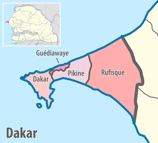
Dakar Region (French: Région de Dakar) is the smallest and most populated Region of Senegal, encompassing the capital city of the country, Dakar, and all its suburbs along the Cap–Vert Peninsula, Africa's most westerly point.
Dakar Region Région de Dakar | |
|---|---|
 Seal | |
 | |
| Coordinates: 14°45′N 17°20′W | |
| Country | Senegal |
| Capital | Dakar |
| Departments | |
| Government | |
| • Regional president | Abdoulaye Faye (PDS; since 2002) |
| Area | |
| • Total | 547 km2 (211 sq mi) |
| Population (2013 census)[1] | |
| • Total | 2,956,023 |
| • Rank | 1st |
| • Density | 5,400/km2 (14,000/sq mi) |
| • Density rank | 1st |
| Time zone | UTC+0 (GMT) |
| ISO 3166-2 | SN-DK |
| Arrondissements | 10[2] |
| Communes | 7,[2] plus 2 communautés rurales |
| Communes d'arrondissement | 43[2] |
| HDI (2017) | 0.617[3] medium · 1st |
Administration
The Dakar region is divided into four départements (administrative structures without political power, unlike the French départements). The départements had the following areas and populations at the Census of 2013:
| Département | Area (km2) | Population Census 2013 |
|---|---|---|
| Dakar | 79 | 1,146,053 |
| Guédiawaye | 13 | 329,659 |
| Pikine | 87 | 1,170,791 |
| Rufisque | 372 | 490,694 |
| Total Région de Dakar | 547 | 3,137,196 |
Dakar department
Dakar Department is also a commune (city). This is a situation comparable to Paris which is both a department and a commune. The department/commune of Dakar is further divided into:
- 4 arrondissements, which are administrative structures without much power. The arrondissements are further divided into:
- 19 communes d'arrondissement (i.e. "communes of arrondissement"). The communes d'arrondissement have a lot of power, unlike the arrondissements of Paris, and are more comparable to the London boroughs.
Guédiawaye department
Guédiawaye Department is also a commune (city). This department has only one arrondissement, so that Guédiawaye is both a department and an arrondissement. The department /arrondissement/commune of Guédiawaye is further divided into:
- 5 communes d'arrondissement
Pikine department
Pikine Department is also a commune (city). The department /commune of Pikine is further divided into:
- 3 arrondissements, which are further divided into:
- 16 communes d'arrondissement
Rufisque department
Rufisque Department is made up of two arrondissements and six urban communes:
- Rufisque arrondissement, which is also a commune (city). The arrondissement/commune of Rufisque is divided into 3 communes d'arrondissement:
- Rufisque Centre (Nord)
- Rufisque Est
- Rufisque Ouest
- Bambylor arrondissement, which, administratively speaking, is the only rural part of the Dakar region. The Bambylor arrondissement is divided into 3 communautés rurales (i.e. "rural communities"):
- Yène
- Bambylor
- Tivaouane Peulh-Niaga
- The six communes of Bargny, Sébikotane, Diamniadio, Jaxaay-Parcelle-Niakoul Rap, Sangalkam and Sendou
Table of Administrative Sub-divisions
| Administrative Divisions of the Dakar Region | ||||
|---|---|---|---|---|
| Département | Commune | Arrondissement | Commune d'arrondissement | Communauté rurale |
| Department/ County / State | City | Borough | Neighborhood | Rural Borough |
| Dakar | Dakar | Almadies | Mermoz-Sacré-Cœur | |
| Almadies | Ngor | |||
| Almadies | Ouakam | |||
| Almadies | Yoff | |||
| Dakar Plateau | Fann-Point E-Amitié | |||
| Dakar Plateau | Gorée | |||
| Dakar Plateau | Gueule Tapée-Fass-Colobane | |||
| Dakar Plateau | Médina | |||
| Dakar Plateau | Plateau | |||
| Grand Dakar | Biscuiterie | |||
| Grand Dakar | Dieuppeul-Derklé | |||
| Grand Dakar | Grand Dakar | |||
| Grand Dakar | Hann-Bel Air | |||
| Grand Dakar | HLM | |||
| Grand Dakar | Sicap-Liberté | |||
| Parcelles Assainies | Cambérène | |||
| Parcelles Assainies | Grand Yoff | |||
| Parcelles Assainies | Parcelles Assainies | |||
| Parcelles Assainies | Patte d'Oie | |||
| Guédiawaye | Guédiawaye | Guédiawaye | Golf Sud | |
| Guédiawaye | Médina Gounass | |||
| Guédiawaye | Ndiarème Limoulaye | |||
| Guédiawaye | Sam Notaire | |||
| Guédiawaye | Wakhinane Nimzatt | |||
| Pikine | Pikine | Dagoudane Arrondissement | Dalifort | |
| Dagoudane | Djidah-Thiaroye Kaw | |||
| Dagoudane | Guinaw Rail Nord | |||
| Dagoudane | Guinaw Rail Sud | |||
| Dagoudane | Pikine Est | |||
| Dagoudane | Pikine Nord | |||
| Dagoudane | Pikine Ouest | |||
| Niayes | Keur Massar | |||
| Niayes | Malika | |||
| Niayes | Yeumbeul Nord | |||
| Niayes | Yeumbeul Sud | |||
| Thiaroye | Diamaguène Sicap Mbao | |||
| Thiaroye | Mbao | |||
| Thiaroye | Thiaroye Gare | |||
| Thiaroye | Thiaroye Sur Mer | |||
| Thiaroye | Tivaouane Diaksao | |||
| Rufisque | Bargny | Rufisque | ||
| Diamnadio | Rufisque | |||
| Jaxaay-Parcelle-Niakoul Rap | Rufisque | |||
| Sangalkam | Rufisque | |||
| Sébikotane | Rufisque | |||
| Sendou | Rufisque | |||
| Rufisque | Rufisque | Rufisque Est | ||
| Rufisque | Rufisque | Rufisque Nord | ||
| Rufisque | Rufisque | Rufisque Ouest | ||
| Bambylor | Bambylor | |||
| Bambylor | Yène | |||
| Bambylor | Tivaouane Peulh-Niaga | |||
Conclusion
Within the Dakar 'region, the only politically significant units (i.e. those who have elected officials and wield a significant power) are: the 7 communes, the 2 communautés rurales, and the 43 communes d'arrondissement.
References
- Agence Nationale de la Statistique et de la Démographie, Government of Senegal (2005). "Situation économique et sociale du Sénégal" (PDF) (in French). p. 163. Archived from the original (PDF) on 2007-06-15. Retrieved 2007-03-08.
- As of December 2005
- "Sub-national HDI - Area Database - Global Data Lab". hdi.globaldatalab.org. Retrieved 2018-09-13.
External links
- (in French)Regional Council of Dakar official website
- (in French)Collectivités locales de Dakar from Republic of Senegal Government site, l'Agence de l'informatique de l'État (ADIE).
- (in French)Décret fixant le ressort territorial et le chef lieu des régions et des départements, décret n°2002-166 du 21 février 2002.
- (in French)Code des collectivités locales, Loi n° 96-06 du 22 mars 1996.