Cygnet River, South Australia
Cygnet River is a locality in the Australian state of South Australia located on Kangaroo Island about 192 kilometres (119 miles) south-west of the state capital of Adelaide and about 12 kilometres (7.5 miles) from the municipal seat of Kingscote.[3]
| Cygnet River South Australia | |||||||||||||||
|---|---|---|---|---|---|---|---|---|---|---|---|---|---|---|---|
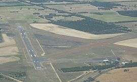
 Kingscote Airport and the adjoining land use as viewed from the north | |||||||||||||||
 Cygnet River | |||||||||||||||
| Coordinates | 35.698280°S 137.519580°E | ||||||||||||||
| Population | 257 (shared with other localities within the “State Suburb of Menzies”) (2011 census)[1][lower-alpha 1] | ||||||||||||||
| Established | 2002[2] | ||||||||||||||
| Postcode(s) | 5223[3] | ||||||||||||||
| Elevation | 6 m (20 ft)[4] | ||||||||||||||
| Time zone | ACST (UTC+9:30) | ||||||||||||||
| • Summer (DST) | ACST (UTC+10:30) | ||||||||||||||
| Location | |||||||||||||||
| LGA(s) | Kangaroo Island Council | ||||||||||||||
| Region | Fleurieu and Kangaroo Island[5] | ||||||||||||||
| County | Carnarvon[2] | ||||||||||||||
| State electorate(s) | Mawson[6] | ||||||||||||||
| Federal Division(s) | Mayo[7] | ||||||||||||||
| |||||||||||||||
| |||||||||||||||
| Footnotes | Distances[3][2] Coordinates[2] Climate[4] Adjoining localities[2] | ||||||||||||||
Its boundaries were created in 2002 in respect to “the long established name” which is reported to be derived from the stream located within its boundaries.[2]
Cygnet River is located within the federal division of Mayo, the state electoral district of Mawson and the local government area of the Kangaroo Island Council.[7][6][2]
Land use
The major land use within the locality is primary production.[8] The locality also includes the Kingscote Airport and the Cygnet Estuary Conservation Park.[8][2]
Cygnet River contains the following places listed on the South Australian Heritage Register - the Farm and Eucalyptus Oil Distillery Ruins, Duck Lagoon and the Dwelling & Eucalyptus Oil Distillery Ruins (Cygnet River).[9][10]
River
The locality of Cygnet River is named for the watercourse also named Cygnet River. It is the longest river on Kangaroo Island. They are named after the Cygnet which was the fifth ship to arrive in South Australia in 1836.[11] The river empties via a delta on the western shore of Western Cove, part of Nepean Bay.[12] It had previously been named the Morgan River after Robert Clark Morgan, the captain of the Duke of York, another of the ships in the First Fleet of South Australia.[13]
References
- Notes
- For the 2011 census, the ‘State Suburb of Menzies’ consisted of the localities of Cassini, Cygnet River, Menzies and Stokes Bay.
- Citations
- Australian Bureau of Statistics (31 October 2012). "Menzies". 2011 Census QuickStats. Retrieved 10 March 2016.

- "Search result for "Cygnet River (Locality Bounded)" (Record no SA0017630) with the following layer being selected - "Suburbs and Localities"". Property Location Browser. Department of Planning, Transport and Infrastructure. Archived from the original on 12 October 2016. Retrieved 10 March 2016.
- "Cygnet River, South Australia (Postcode)". postcodes-australia.com. Retrieved 10 March 2016.
- "Monthly climate statistics: Summary statistics KINGSCOTE AERO". Commonwealth of Australia , Bureau of Meteorology. Retrieved 8 March 2016.
- "Fleurieu and Kangaroo Island SA Government region" (PDF). The Government of South Australia. Retrieved 9 September 2016.
- Mawson (Map). Electoral District Boundaries Commission. 2016. Retrieved 2 March 2018.
- "Federal electoral division of Mayo, boundary gazetted 16 December 2011" (PDF). Australian Electoral Commission. Retrieved 2 August 2015.
- "Development Plan, Kangaroo Island Council" (PDF). Department of Planning, Transport and Infrastructure. pp. 159, 260, 282 & 287. Retrieved 8 March 2016.
- "Farm and Eucalyptus Oil Distillery Ruins, Duck Lagoon". South Australian Heritage Register. Department of Environment, Water and Natural Resources. Retrieved 1 June 2016.
- "Dwelling & Eucalyptus Oil Distillery Ruins". South Australian Heritage Register. Department of Environment, Water and Natural Resources. Retrieved 1 June 2016.
- "Place Names of South Australia". The Manning Index of South Australian History. State Library of South Australia. Retrieved 15 April 2020.
- "Cygnet River Delta". Beachsafe. Surf Life Saving Australia. Retrieved 15 April 2020.
- "Morgan River". Bound for South Australia. Retrieved 15 April 2020.