Compreignac
Compreignac (Occitan: Comprenhac) is a commune in the Haute-Vienne department in the Nouvelle-Aquitaine region in western France.
Compreignac | |
|---|---|
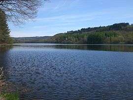 The Saint-Pardoux Lake, north of the village of Compreignac | |
.svg.png) Coat of arms | |
Location of Compreignac 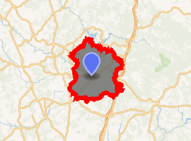
| |
 Compreignac  Compreignac | |
| Coordinates: 45°59′34″N 1°16′32″E | |
| Country | France |
| Region | Nouvelle-Aquitaine |
| Department | Haute-Vienne |
| Arrondissement | Bellac |
| Canton | Bellac |
| Government | |
| • Mayor (2001–2008) | Jacques Pleinevert |
| Area 1 | 47.62 km2 (18.39 sq mi) |
| Population (2017-01-01)[1] | 1,838 |
| • Density | 39/km2 (100/sq mi) |
| Time zone | UTC+01:00 (CET) |
| • Summer (DST) | UTC+02:00 (CEST) |
| INSEE/Postal code | 87047 /87140 |
| Elevation | 301–587 m (988–1,926 ft) |
| 1 French Land Register data, which excludes lakes, ponds, glaciers > 1 km2 (0.386 sq mi or 247 acres) and river estuaries. | |
Geography
The commune covers 4,762 hectares. Compreignac is located 20 km (12 mi) to the north of the city of Limoges, approximately 10 minute travel along the Autoroute A20.
Inhabitants are known as Compreignacois.
gollark: It's been a while since I did NC reactor design, but that seems plausible depending on your goals.
gollark: (this information was obtained via htop)
gollark: Did you know? The osmarks.net HDD™ is currently doing 5MB/s of reads.
gollark: Okay. That does make your question slightly odd.
gollark: Does git actually have repo names?
References
- "Populations légales 2017". INSEE. Retrieved 6 January 2020.
| Wikimedia Commons has media related to Compreignac. |
| Authority control |
|
|---|
This article is issued from Wikipedia. The text is licensed under Creative Commons - Attribution - Sharealike. Additional terms may apply for the media files.