Chikuhoku, Nagano
Chikuhoku (筑北村, Chikuhoku-mura) is a village located in Nagano Prefecture, Japan. As of 28 February 2018, the village had an estimated population of 4,688 in 1873 households, and a population density of 47 persons per km².[1] The total area of the village is 99.47 square kilometres (38.41 sq mi).[2]
Chikuhoku 筑北村 | |
|---|---|
Village | |
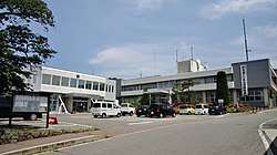 Chikuhoku Village Hall | |
 Flag  Seal | |
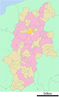 Location of Chikuhoku in Nagano Prefecture | |
 Chikuhoku | |
| Coordinates: 36°25′34.8″N 138°0′55″E | |
| Country | Japan |
| Region | Chūbu (Kōshin'etsu) |
| Prefecture | Nagano |
| District | Higashichikuma |
| Area | |
| • Total | 99.47 km2 (38.41 sq mi) |
| Population (February 2018) | |
| • Total | 4,688 |
| • Density | 47/km2 (120/sq mi) |
| Time zone | UTC+9 (Japan Standard Time) |
| Symbols | |
| Phone number | 0263-66-2111 |
| Address | 2187 Sakakita, Chikuhoku-mura, Higashichikuma-gun, Nagano-ken 399-7601 |
| Website | Official website |
Geography
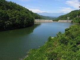
Chikuhoku is located in the center of Nagano Prefecture in the Matsumoto Basin. Higashijo Dam and Onikuma Dam are located in Chikuhoku.
Demographics
Per Japanese census data,[3] the population of Chikuhoku has been declining over the past 50 years.
| Year | Pop. | ±% |
|---|---|---|
| 1940 | 8,886 | — |
| 1950 | 11,361 | +27.9% |
| 1960 | 9,757 | −14.1% |
| 1970 | 8,105 | −16.9% |
| 1980 | 7,556 | −6.8% |
| 1990 | 7,111 | −5.9% |
| 2000 | 6,049 | −14.9% |
| 2010 | 5,173 | −14.5% |
Climate
The village has a climate characterized by characterized by cool and humid summers, and cold winters (Köppen climate classification Dfa. The average annual temperature in Chikuhoku is 9.6 °C. The average annual rainfall is 1227 mm with September as the wettest month. The temperatures are highest on average in August, at around 22.8 °C, and lowest in January, at around -3.0 °C.[4]
History
The area of present-day Chikuhoku was part of ancient Shinano Province. Most of the area was under the control of Matsumoto Domain during the Edo period. The villages of Honjō, Sakakita, and Sakai were created with the establishment of the modern municipalities system on April 1, 1889. The village of Chikuhoku was incorporated on October 11, 2005 by a merger of the three villages.[5]
Education
Chikuhoku has three public elementary schools and one public middle school operated by the village government, and one middle school operated jointly between Chikuhoku and neighboring Omi village. The village does not have a high school.
Transportation
Railway
Highway
Local attractions
- Site of Aoyagi Castle
- Mount Kamuriki, known in Japanese folklore as the location of Mount Ubasute
Notable people from Chikuhoku
- Tomio Hora, historian
References
- Village of Chikuhoku. 筑北村の人口 (in Japanese). Retrieved April 6, 2019.
- Village of Chikuhoku. 位置及び地勢 (in Japanese). Archived from the original on August 13, 2007. Retrieved October 16, 2007.
- Chikuhoku population statistics
- Chikuhoku climate data
- Village of Chikuhoku. 合併の歴史 (in Japanese). Archived from the original on November 11, 2007. Retrieved October 16, 2007.
External links

- Official Website (in Japanese)
Nagano (capital) | |
| Core city |
|
| Special city | |
| Cities | |
| Districts | |
| Authority control |
|
|---|