Chanchal
Chanchal is a census town in Malda district in the state of West Bengal, India. It is the headquarters of the Chanchal subdivision.
Chanchal | |
|---|---|
Census Town | |
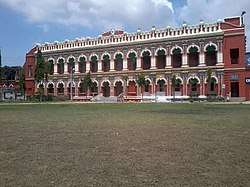 Chanchal Rajbari | |
 Chanchal Location in West Bengal, India  Chanchal Chanchal (India)  Chanchal Chanchal (Asia) | |
| Coordinates: 25.39°N 87.99°E | |
| Country | |
| State | West Bengal |
| District | Malda |
| Population (2011)[1] | |
| • Total | 5,570 |
| Languages | |
| • Official | Bengali[2][3] |
| • Additional official | English[2] |
| Time zone | UTC+5:30 (IST) |
| PIN | 732123 |
| Vehicle registration | WB 83/WB 84 |
| Lok Sabha constituency | Maldaha Uttar |
| Vidhan Sabha constituency | Chanchal |
| Website | wb |
History
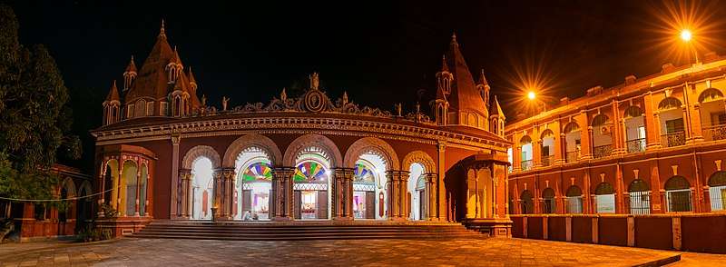
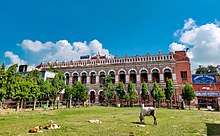
It was the home of Raja Saratchandra Rai Bahadur, who built the Chanchal palace. The King was married to Queen Dakshyani. One part of the palace was transformed into a government college in 1969.The other part of the Palace is now Chanchal Subdivisional Court.
Geography
Chanchal is located at 25.39°N 87.99°E.[4] Chanchal is the headquarter of the Chanchal subdivision. Also, the headquarter of the Chanchal–I CD block is here.[5]
There is an announcement that Chanchal and Gazole would be amongst the 22 new municipalities to be formed in West Bengal.[6]The matter has also been reported in the press, but till November 2018, there has been no formal announcement or notification.[7]
Climate
Chanchal has three distinct seasons: summer, winter and monsoon. In summer the temperature sometimes reaches 45 degree Celsius. Winters are generally chilled and cool and sometimes temperature goes below 3 degree Celsius. During the monsoons (between June and September), the town is lashed by moderate to heavy rains.
Demographics
As of 2011 Indian Census, Chanchal had a total population of 5,570, of which 2,827 were males and 2,743 were females. Population within the age group of 0 to 6 years was 634. The total number of literates in Chanchal was 3,852, which constituted 69.2% of the population with male literacy of 72.4% and female literacy of 65.8%. The effective literacy rate of 7+ population of Chanchal was 78.0%, of which male literacy rate was 82.0% and female literacy rate was 74.0%. The Scheduled Castes and Scheduled Tribes population was 919 and 4 respectively. Chanchal had 1311 households in 2011.[1]
Administration
Police station
Chanchal police station under West Bengal police has jurisdiction over Chanchal I and Chanchal II CD Blocks.[8][9]
Transport
Chanchal is on National Highway 31.[12]
Education
- Chanchal Siddheswari Institution
- Chanchal College
Healthcare
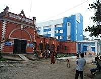
Chanchal Super Speciality Hospital at Chanchal Roy Para, Chanchal (with blood bank and other digital facilities) is a major medical facility. There are primary health centres in Chanchal I CD Block at Kharba (with 10 beds) and Singia (Nadishik PHC) (with 10 beds).[13]
Notable people
References
- "Census of India: Chanchal". www.censusindia.gov.in. Retrieved 13 November 2019.
- "Fact and Figures". www.wb.gov.in. Retrieved 15 January 2019.
- "52nd REPORT OF THE COMMISSIONER FOR LINGUISTIC MINORITIES IN INDIA" (PDF). nclm.nic.in. Ministry of Minority Affairs. p. 85. Archived from the original (PDF) on 25 May 2017. Retrieved 15 January 2019.
- "Yahoo maps location of Chanchal". Yahoo maps. Retrieved 7 December 2008.
- "Contact details of Block Development Officers". Malda district. Panchayats and Rural Development Department, Government of West Bengal. Retrieved 26 December 2008.
- "Decentralisation of Governance: 22 new municipalities to come up in Bengal". All India Trinamool Congress. Retrieved 23 October 2018.
- "West Bengal to have 22 new municipalities". Outlook 11 June 2014. Retrieved 23 October 2018.
- "District Statistical Handbook 2014 Malda". Table 2.1, 2.2, 2.4b. Department of Statistics and Programme Implementation, Government of West Bengal. Archived from the original on 21 January 2019. Retrieved 9 November 2018.
- "Malda District Police". Telephone Numbers. District Police. Archived from the original on 9 November 2018. Retrieved 9 November 2018.
- "District Census Handbook: Maldah, Series 20 Part XII A" (PDF). Map of Maldah with CD Block HQs and Police Stations (on the fourth page). Directorate of Census Operations, West Bengal, 2011. Retrieved 9 November 2018.
- "BDO Offices under Malda District". Department of Mass Education Extension & Library Services, Government of West Bengal. West Bengal Public Library Network. Retrieved 8 November 2018.
- Google maps
- "Health & Family Welfare Department". Health Statistics. Government of West Bengal. Retrieved 14 November 2018.