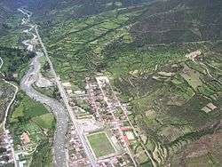
Chalhuanca District
Chalhuanca District is one of the seventeen districts of the Aymaraes Province in Peru.[1]
Chalhuanca | |
|---|---|
 Chalhuanca | |
| Country | |
| Region | Apurímac |
| Province | Aymaraes |
| Capital | Chalhuanca |
| Government | |
| • Mayor | Sebastian Gonzalo Carbajal Zegarra |
| Area | |
| • Total | 322.34 km2 (124.46 sq mi) |
| Elevation | 2,888 m (9,475 ft) |
| Population (2005 census) | |
| • Total | 4,658 |
| • Density | 14/km2 (37/sq mi) |
| Time zone | UTC-5 (PET) |
| UBIGEO | 030401 |
Geography
One of the highest peaks of the district is Pisti at approximately 5,100 m (16,700 ft). Other mountains are listed below:[2]
- Apu Wansillu
- Chawpi Urqu
- Hatun Waraqu
- Kampanayuq
- Millu
- Muruni
- Nina Q'asa
- Pilluni
- Qucha Pampa
- Qucha Qucha
- Qura Unu
- Q'illu Qaqa
- Wayna P'ukru
- Wayra Tuqlla
- Sinqa Sinqa
- T'uru P'unqu
- Wallulluni
- Wayllayuq
- Yana Ranra
- Yana Qucha
- Yana Urqu
- Yawri Qucha
gollark: Just make a trait.
gollark: Also, casting via as then try_into-ing is pointless.
gollark: Also, instead of get then unwrap, simply do map[&(target-num)].
gollark: That should implement Copy, so just dereference it.
gollark: There's an option method to convert Option<&T> to &Option<T>, yes?
References
- (in Spanish) Instituto Nacional de Estadística e Informática. Banco de Información Digital Archived April 23, 2008, at the Wayback Machine. Retrieved April 7, 2008.
- escale.minedu.gob.pe/ UGEL map Cotabambas Province (Apurímac Region)
| |
|---|---|
| Abancay | |
| Andahuaylas | |
| Antabamba | |
| Aymaraes | |
| Chincheros | |
| Cotabambas | |
| Grau | |
This article is issued from Wikipedia. The text is licensed under Creative Commons - Attribution - Sharealike. Additional terms may apply for the media files.