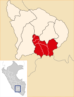
Antabamba Province
Antabamba Province is one of the seven provinces of the Apurímac Region in Peru. The capital of the province is the city of Antabamba.
Antabamba | |
|---|---|
 Coat of arms | |
 Location of Antabamba in the Apurímac Region | |
| Country | Peru |
| Region | Apurímac |
| Capital | Antabamba |
| Area | |
| • Total | 3,219.01 km2 (1,242.87 sq mi) |
| Population | |
| • Total | 11,932 |
| • Density | 3.7/km2 (9.6/sq mi) |
| Website | www |
Boundaries
- North: Grau Province
- East: Cotabambas Province, Cusco Region
- South: Arequipa Region
- West: Aymaraes Province
Geography
Antabamba Province covers an area of 1,242.33 square kilometres (479.67 sq mi). The Wansu mountain range traverses the province. Some of the highest peaks of the province are listed below:[1]
- Allqa Walusa
- Aqu Q'asa
- Chachakumani
- Chaku Q'asa
- Chankuwaña
- Hatun Qillqa
- Hatun Q'asa
- Hatunqullpa
- Huch'uy Sara Sara
- Ikma
- Inti Utka
- Kimsaqucha
- Kisu Qutu
- Kiswarani
- Kuntur Wachana
- Kuntur Wasi
- Kunturi
- Luychu
- Lunq'u
- Llamuqa
- Llaqtarana
- Llulluch'a
- Lluqu Chuyma
- Maranniyuq
- Millu
- Mina Q'asa
- Misa Urqu
- Muntirayuq
- Muruq'u
- Pachak Pata
- Paychi (Antabamba)
- Paychi (Antabamba-Esp. Medr.)
- Pilluni
- Pirqa
- Puka Puka
- Puka Ranra
- Puka Urqu (Antabamba)
- Puka Urqu (Oropesa)
- Puka Willka
- Pumanuta
- Phiruru
- Qillqa
- Quncha Urqu
- Quri Pawkara
- Quri Waraqa
- Q'illu
- Q'illu Pachaka
- Q'illu Urqu
- Q'illu Wachu
- Runtu Quri
- Runtuqucha
- Salli
- Sara Sara
- Saywa Punta
- Sisiwa
- Suntur
- Sura Kallanka
- Surapata
- Taruja Marka
- T'alla Kallanka
- Uqi Saywa
- Urpi Marka
- Utkhu
- Waman Ch'arpa
- Wamanripa
- Wank'ayuq Saywa
- Waytani
- Wayunka
- Wila Quta
- Willkarana
- Wiska
- Yana Ranra
- Yana Uqhu
- Yana Urqu
- Yawriwiri
- Yuraq Qaqa
- Yuraq Urqu
- Yuraq Wasina
Districts
The province is divided into seven districts:
Ethnic groups
The people in the province are mainly indigenous citizens of Quechua descent. Quechua is the language which the majority of the population (77.12%) learnt to speak in childhood, 22.26% of the residents started speaking using the Spanish language and 0.28% using Aymara (2007 Peru Census).[2]
Sources
- escale.minedu.gob.pe - UGEL map of the Antabamba Province and the Grau Province (Apurímac Region)
- inei.gob.pe Archived January 27, 2013, at the Wayback Machine INEI, Peru, Censos Nacionales 2007
gollark: It should (assuming I'm correct about my fusion reactor failing and the battery buffer's battery buffering) lose power and be okay in no more than a wekk.
gollark: If you're close enough to look, CRASH.
gollark: You can't boot them off disk drives.
gollark: ... yes.
gollark: I'm sure you can send a command every 0.05 seconds over that or something/
External links
This article is issued from Wikipedia. The text is licensed under Creative Commons - Attribution - Sharealike. Additional terms may apply for the media files.