Centerville, Indiana
Centerville is a town in Center Township, Wayne County, in the U.S. state of Indiana.[6] The population was 2,552 at the 2010 census.
Centerville, Indiana | |
|---|---|
 | |
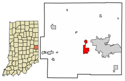 Location of Centerville in Wayne County, Indiana. | |
| Coordinates: 39°48′58″N 84°59′44″W | |
| Country | United States |
| State | Indiana |
| County | Wayne |
| Township | Center |
| Area | |
| • Total | 3.52 sq mi (9.11 km2) |
| • Land | 3.49 sq mi (9.05 km2) |
| • Water | 0.02 sq mi (0.06 km2) |
| Elevation | 1,010 ft (308 m) |
| Population | |
| • Total | 2,552 |
| • Estimate (2019)[4] | 2,579 |
| • Density | 738.12/sq mi (284.95/km2) |
| Time zone | UTC-5 (EST) |
| • Summer (DST) | UTC-5 (EST) |
| ZIP code | 47330 |
| Area code(s) | 765 |
| FIPS code | 18-11836[5] |
| GNIS feature ID | 432346 |
| Website | http://www.town.centerville.in.us/ |
Geography
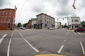
Centerville is located at 39°48′58″N 84°59′44″W (39.816141, -84.995420),[7] at an altitude of 1,014 feet (309 m).[8] U.S. Route 40 runs east and west through town along Main Street.
According to the 2010 census, Centerville has a total area of 2.4 square miles (6.22 km2), all land.[9]

Demographics
| Historical population | |||
|---|---|---|---|
| Census | Pop. | %± | |
| 1850 | 920 | — | |
| 1860 | 960 | 4.3% | |
| 1870 | 1,077 | 12.2% | |
| 1880 | 875 | −18.8% | |
| 1890 | 864 | −1.3% | |
| 1900 | 785 | −9.1% | |
| 1910 | 1,019 | 29.8% | |
| 1920 | 917 | −10.0% | |
| 1930 | 993 | 8.3% | |
| 1940 | 1,162 | 17.0% | |
| 1950 | 1,386 | 19.3% | |
| 1960 | 2,378 | 71.6% | |
| 1970 | 2,380 | 0.1% | |
| 1980 | 2,284 | −4.0% | |
| 1990 | 2,398 | 5.0% | |
| 2000 | 2,427 | 1.2% | |
| 2010 | 2,552 | 5.2% | |
| Est. 2019 | 2,579 | [4] | 1.1% |
| U.S. Decennial Census[10] | |||
2010 census
As of the census[3] of 2010, there were 2,552 people, 1,038 households, and 738 families living in the town. The population density was 1,063.3 inhabitants per square mile (410.5/km2). There were 1,147 housing units at an average density of 477.9 per square mile (184.5/km2). The racial makeup of the town was 96.1% White, 0.6% African American, 0.1% Native American, 0.6% Asian, 1.3% from other races, and 1.2% from two or more races. Hispanic or Latino of any race were 2.5% of the population.
There were 1,038 households, of which 37.8% had children under the age of 18 living with them, 49.6% were married couples living together, 17.1% had a female householder with no husband present, 4.4% had a male householder with no wife present, and 28.9% were non-families. 26.1% of all households were made up of individuals, and 9.9% had someone living alone who was 65 years of age or older. The average household size was 2.46 and the average family size was 2.95.
The median age in the town was 37.1 years. 27.4% of residents were under the age of 18; 7.3% were between the ages of 18 and 24; 26.8% were from 25 to 44; 24.9% were from 45 to 64; and 13.5% were 65 years of age or older. The gender makeup of the town was 47.5% male and 52.5% female.
2000 census
As of the census[5] of 2000, there were 2,427 people, 944 households, and 676 families living in the town. The population density was 2,421.5 people per square mile (937.1/km2). There were 1,001 housing units at an average density of 998.7 per square mile (386.5/km2). The racial makeup of the town was 98.48% White, 0.21% African American, 0.04% Native American, 0.29% Asian, 0.74% from other races, and 0.25% from two or more races. Hispanic or Latino of any race were 1.07% of the population.
There were 944 households, out of which 36.7% had children under the age of 18 living with them, 52.8% were married couples living together, 15.6% had a female householder with no husband present, and 28.3% were non-families. 26.2% of all households were made up of individuals, and 11.1% had someone living alone who was 65 years of age or older. The average household size was 2.46 and the average family size was 2.95.
In the town, the population was spread out, with 27.3% under the age of 18, 7.5% from 18 to 24, 28.8% from 25 to 44, 18.9% from 45 to 64, and 17.6% who were 65 years of age or older. The median age was 36 years. For every 100 females, there were 84.0 males. For every 100 females age 18 and over, there were 77.7 males.
The median income for a household in the town was $32,219, and the median income for a family was $37,566. Males had a median income of $31,875 versus $22,450 for females. The per capita income for the town was $15,526. About 5.3% of families and 6.7% of the population were below the poverty line, including 9.7% of those under age 18 and 3.5% of those age 65 or over.
History
Centerville was platted in 1814 on land that once belonged to the Miami Indians and was settled by Quakers from Carolina and Virginia. The community was named for its location near the middle of the county.[11] A little-known county seat war was fought in Wayne County, Indiana, in 1873 between Centerville and Richmond. The county seat had been located in Centerville (Center Township) since 1818.[12] By 1870, Richmond (Wayne Township) had surpassed Centerville in business, population, and tax revenue. These factors led the population of Wayne Township to demand the county seat be moved to Richmond. The dispute was played out in the newspapers, courts, and petitions with Richmond the eventual winner. A new courthouse was erected in Richmond and preparations were made to move records from Centerville to Richmond. Centerville stopped Richmond's officials’ efforts to move the records twice. Once with locked gates with guards and the second by firing on their own courthouse with a three-pound cannon nicknamed “Black Betty.” The cannon was used when Richmond guards were brought in to protect the records. The cannon had been loaded with iron scraps. A crowd demanded the guard come out of the Centerville courthouse. When they refused, the cannon was fired, the door blown off its hinges, and the guards were forced to beat a hasty retreat.[13]
Soldiers were brought in the next day to move the records to Richmond. Centerville's tenure as county seat had come to an end.
The holes from the cannon shot are still visible over the door of the old courthouse, now the Center Township Library.
 Center Township Library
The Centerville post office has been in operation since 1818.[14]
In 1828, the National Road, Main Street, was surveyed and later became the first improved section of the trail in 1850 by a Special Act of the U.S. Congress.
Centerville's cobblestone street was a major stop along the trail to the West. During the height of the Gold Rush, 49,000 wagons would travel along the street each year.
Centerville is known as the “City of Arches” due to the five main arches it has located on the Old National Road. The road used to be 100 feet wide, but was shortened to 65 feet due to the people of Centerville adding on to the front of the businesses and houses. The arches were used as a way to get behind the buildings and into the backyards of the houses.[15] The five arches that are located in Centerville are the Backenstoes Archway, Dill Archway, Shortridge Archway, Lantz Archway, and Malone Archway. They were all built between 1823 and 1836.[16] They are all located on National Road in Centerville. In August, Centerville has Archway Days, which is held in celebration and honor of the historical archways. They have food, games, and prizes, which attracts people from all over the state.
 Backenstoes Archway
 Shortridge Archway
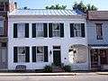 Malone Archway
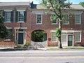 Lantz Archway
 Dill Archway
The Centerville Historic District (Centerville, Indiana), Oliver P. Morton House, and Westcott Stock Farm are listed on the National Register of Historic Places.[17]
Education
Centerville teenagers attend Centerville Senior High School.
The town has a lending library, the Centerville-Center Township Public Library.[18]
Notable people
- John A. Burbank, Governor of Dakota Territory
- Barry Jones, pitcher in Major League Baseball
- George Washington Julian, state and U.S. Representative
- Joseph Henry Kibbey, Governor of the Arizona Territory
- Oliver Hazard Perry Morton, Governor of Indiana and U.S. Senator from Indiana
References
- "2019 U.S. Gazetteer Files". United States Census Bureau. Retrieved July 16, 2020.
- "US Board on Geographic Names". United States Geological Survey. October 25, 2007. Retrieved 2016-07-07.
- "U.S. Census website". United States Census Bureau. Retrieved 2012-12-11.
- "Population and Housing Unit Estimates". United States Census Bureau. May 24, 2020. Retrieved May 27, 2020.
- "U.S. Census website". United States Census Bureau. Retrieved 2008-01-31.
- "Centerville, Indiana". Geographic Names Information System. United States Geological Survey. Retrieved 2016-07-07.
- "US Gazetteer files: 2010, 2000, and 1990". United States Census Bureau. 2011-02-12. Retrieved 2011-04-23.
- U.S. Geological Survey Geographic Names Information System: Centerville, Indiana
- "G001 - Geographic Identifiers - 2010 Census Summary File 1". United States Census Bureau. Archived from the original on 2020-02-13. Retrieved 2015-07-13.
- "Census of Population and Housing". Census.gov. Retrieved June 4, 2015.
- "Profile for Centerville, IN". ePodunk. Retrieved July 7, 2016.
- "History of Richmond & Wayne County, Indiana". WayNet. Retrieved 2 June 2014.
- Spahr, W. E. (1966). "Center Township Library, Centerville, Indiana".> Retrieved July 18, 2010, from Waynet.org.
- "Wayne County". Jim Forte Postal History. Archived from the original on September 14, 2005. Retrieved July 7, 2016.
- "Centerville, Indiana: The city of arches". (2008, March 10). "Archived copy". Archived from the original on 2011-07-15. Retrieved 2010-07-22.CS1 maint: archived copy as title (link) Retrieved July 16, 2010, from The Lantz House and Gathering Place Inn.
- "Centerville, Indiana" . (2010)..Retrieved July 16, 2010, from Waynet: Community Network Association.
- "National Register Information System". National Register of Historic Places. National Park Service. July 9, 2010.
- "Indiana public library directory" (PDF). Indiana State Library. Retrieved 15 March 2018.
External links
Municipalities and communities of Wayne County, Indiana, United States | ||
|---|---|---|
| City | Map of Indiana highlighting Wayne County | |
| Towns | ||
| Townships | ||
| Unincorporated communities | ||