Center Township, Washington County, Arkansas
Center Township is one of 37 townships in Washington County, Arkansas, USA.[2] At the 2010 census, its total population was 1,518.
Township of Center | |
|---|---|
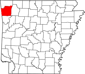
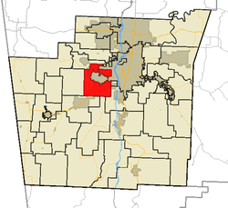 Center Township in Washington County, Arkansas | |
| Coordinates: 36°02′45″N 94°15′46″W | |
| Country | |
| State | |
| County | Washington |
| Established | 1880[1] |
| Area | |
| • Total | 9.13 sq mi (23.6 km2) |
| • Land | 9.09 sq mi (23.5 km2) |
| • Water | 0.04 sq mi (0.1 km2) 0% |
| Elevation | 1,227 ft (374 m) |
| Population (2010) | |
| • Total | 1,518 |
| • Density | 167/sq mi (64/km2) |
| Time zone | UTC-6 (CST) |
| • Summer (DST) | UTC-5 (CDT) |
| Area code(s) | 479 |
| GNIS feature ID | 69782 |
| U.S. Geological Survey Geographic Names Information System: Center Township, Washington County, Arkansas | |
Center Township was established in 1880.[3]
Geography
According to the United States Census Bureau, Center Township covers an area of 21.3 square miles (55 km2); all land.[2] Center Township was created in 1880 from parts of Prairie and Marrs Hill Townships.[1] It has three disconnected sections.
Cities, towns, villages
Cemeteries
The township contains one cemetery, Cemetery Hill.
Major routes
gollark: ++invite
gollark: ++remind 7mo initiate contingency for Ω-class event (again)
gollark: MUAHAHAHAHA.
gollark: ?tag create dft The DFT is the most important discrete transform, used to perform Fourier analysis in many practical applications.[1] In digital signal processing, the function is any quantity or signal that varies over time, such as the pressure of a sound wave, a radio signal, or daily temperature readings, sampled over a finite time interval (often defined by a window function[2]). In image processing, the samples can be the values of pixels along a row or column of a raster image. The DFT is also used to efficiently solve partial differential equations, and to perform other operations such as convolutions or multiplying large integers.
gollark: I really should thingy esobot one of these days.
References
- United States Census Bureau 2008 TIGER/Line Shapefiles
- United States Board on Geographic Names (GNIS)
- United States National Atlas
- Baker, Russell (2003). Arkansas Township Atlas 1819-1930. Little Rock, AR: Arkansas Genealogical Society. p. 148. ISBN 0-9723085-6-3.
- "Township of Center, Washington County, Arkansas." U.S. Census Bureau. Breakdown. Retrieved September 15, 2010.
- History of Benton, Washington, Carroll, Madison, Crawford, Franklin, and Sebastian Counties, Arkansas. Higginson Book Company. 1889. p. 167.
External links
Places adjacent to Center Township, Washington County, Arkansas | ||||||||||
|---|---|---|---|---|---|---|---|---|---|---|
| ||||||||||
This article is issued from Wikipedia. The text is licensed under Creative Commons - Attribution - Sharealike. Additional terms may apply for the media files.