Castelnuovo Rangone
Castelnuovo Rangone (Modenese: Castelnôv) is a comune (municipality) in the Province of Modena in the Italian region Emilia-Romagna, located about 40 kilometres (25 mi) west of Bologna and about 13 kilometres (8 mi) south of Modena. The most important economic activity is the production and treatment of pork.
Castelnuovo Rangone | |
|---|---|
| Comune di Castelnuovo Rangone | |
Location of Castelnuovo Rangone 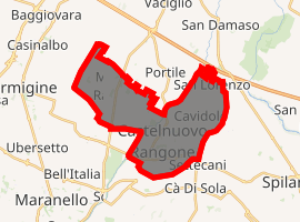
| |
 Castelnuovo Rangone Location of Castelnuovo Rangone in Italy 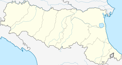 Castelnuovo Rangone Castelnuovo Rangone (Emilia-Romagna) | |
| Coordinates: 44°33′N 10°56′E | |
| Country | Italy |
| Region | Emilia-Romagna |
| Province | Modena (MO) |
| Frazioni | Montale, Cavidole, San Lorenzo |
| Government | |
| • Mayor | Massimo Paradisi |
| Area | |
| • Total | 22.44 km2 (8.66 sq mi) |
| Elevation | 76 m (249 ft) |
| Population (31 August 2017)[2] | |
| • Total | 15,008 |
| • Density | 670/km2 (1,700/sq mi) |
| Demonym(s) | Castelnovesi |
| Time zone | UTC+1 (CET) |
| • Summer (DST) | UTC+2 (CEST) |
| Postal code | 41051 |
| Dialing code | 059 |
| Patron saint | Saint Celestine |
| Saint day | 6 April |
| Website | Official website |
Castelnuovo Rangone borders the following municipalities: Castelvetro di Modena, Formigine, Modena, Spilamberto.
Twin towns
Castelnuovo Rangone is twinned with:
gollark: It's a bot channel, why do you even have it unmuted?
gollark: 🐝 you, I fixed that bug.
gollark: h you.
gollark: Um.
gollark: ... no.
References
- "Superficie di Comuni Province e Regioni italiane al 9 ottobre 2011". Istat. Retrieved 16 March 2019.
- Municipality of Castelnuovo Rangone.
This article is issued from Wikipedia. The text is licensed under Creative Commons - Attribution - Sharealike. Additional terms may apply for the media files.