Canning Dock
Canning Dock on the River Mersey is part of the Port of Liverpool in Northern England. The dock is in the southern dock system, connected to Salthouse Dock to the south and with access to the river via the Canning Half Tide Dock to the west. The Canning Graving Docks are accessed from the dock.
| Canning Dock | |
|---|---|
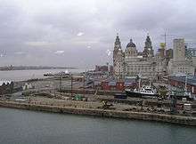
Boats visiting in 2005, looking towards the Pier Head | |
| Location | |
| Location | Liverpool, United Kingdom |
| Coordinates | 53.4026°N 2.9918°W |
| OS grid | SJ341899 |
| Details | |
| Owner | Canal & River Trust[1] |
| Opened | 1737 |
| Type | Wet dock |
| Joins | |
| Area | 4 acres (1.6 ha), 376 sq yd (314 m2)[2] |
| Width at entrance | 45 ft (14 m)[3] |
| Quay length | 585 yd (535 m)[3] |
History

Canning Dock was opened in 1737 as the Dry Dock, a protected tidal basin providing an entrance to Old Dock. Having been subsequently enclosed as a wet dock three years earlier,[4] in 1832 it was officially named after the Liverpool MP George Canning. To the east is the site of Old Dock, built in 1709, which was the world's first enclosed commercial dock. Canning Dock would have initially served ships involved in the trans Atlantic slave trade.
Access to the northern half of the dock system was via Georges Dock, George's Basin and into Prince's Dock. In 1899, Georges Basin and George's Dock were filled in and the site is now the Pier Head.[5]
Along with the Albert Dock and others in the immediate vicinity, Canning Dock was abandoned as a commercial shipping facility in 1972 due to the rising cost of dredging and falling traffic.[6]
Graving docks

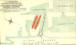
Adjoining the dock basin are two dry graving dock built by Henry Berry[7] between 1765-9. They were lengthened and deepened by Jesse Hartley in the 1840s.[4]
Redevelopment
Canning Dock was restored from 1983[4] providing access to the Canning Graving Docks, which are part of the Merseyside Maritime Museum.
By March 2009 work was completed[8][9] on a £22 million extension of the Leeds and Liverpool Canal, providing a further 1.4 mi (2.3 km) of navigable waterway.[10]
From Princes Dock, the extension passes the Pier Head and terminates at Canning Dock.[10] The extension includes a small canal basin at Mann Island near Pier Head, and a new lock providing access to Canning Dock.[11]
References
- "Liverpool Canal Link Skipper's Guide" (PDF). Canal & River Trust. August 2015. p. 2. Retrieved 28 August 2016.
- Baines 1859, Part II, p. 97
- Baines 1859, Part II, p. 116
- Pollard & Pevsner 2006, p. 271
- "Trading Places: A History of Liverpool Docks". Liverpool Museums. Archived from the original on 28 October 2008. Retrieved 20 March 2008.
- "Trading Places: Canning Dock History". Liverpool Museums. Archived from the original on 11 September 2009. Retrieved 7 January 2008.
- Ashmore 1982, p. 162
- "Liverpool Canal Link, March 2009 (Page 1: Salthouse Dock, Mann Island)". Pennine Waterways. Retrieved 8 July 2009.
- "New canal link to boost tourism". BBC News. 25 March 2009. Retrieved 8 July 2009.
- "Liverpool Canal Link: The Scheme". British Waterways. Archived from the original on 28 July 2009. Retrieved 8 July 2009.
- "Liverpool Canal Link, before work began (Page 3)". Pennine Waterways. Retrieved 6 April 2008.
Sources
- Ashmore, Owen (1982). The Industrial Archaeology of North-west England. Manchester University Press. ISBN 9780719008207. OCLC 8555887.CS1 maint: ref=harv (link)
- Baines, Thomas (1859). Liverpool in 1859. London: Longman & Co. OCLC 43484994.CS1 maint: ref=harv (link)
- Pollard, Richard; Pevsner, Nikolaus (2006). Lancashire: Liverpool and the South West. Yale University Press. ISBN 9780300109108. OCLC 63396571.CS1 maint: ref=harv (link)
Further reading
- McCarron, Ken; Jarvis, Adrian (1992). Give a Dock a Good Name?. Birkenhead: Merseyside Port Folios. pp. 23–24. ISBN 9780951612941. OCLC 27770301.
- Moss, Linda; Stammers, Michael (1980). Foster, Richard (ed.). Liverpool's South Docks. Part 1. Mann Island — Wapping Basin. Merseyside County Museums. pp. 23–36. ISBN 9780906367087. OCLC 9918913.
External links
| Wikimedia Commons has media related to Canning Dock. |
- "Liverpool South Docks diagram". Archived from the original on 7 January 2009.
- Canning Dock aerial photo
- Merseyside Maritime Museum