Campbellfield, Victoria
Campbellfield is a suburb of Melbourne, Victoria, Australia, 16 km north of Melbourne's central business district. Its local government area is the City of Hume. At the 2016 Census, Campbellfield had a population of 5,056.[1]
| Campbellfield Melbourne, Victoria | |||||||||||||||
|---|---|---|---|---|---|---|---|---|---|---|---|---|---|---|---|
 Campbellfield | |||||||||||||||
| Coordinates | 37.673°S 144.957°E | ||||||||||||||
| Population | 5,056 (2016)[1] | ||||||||||||||
| • Density | 407.7/km2 (1,056/sq mi) | ||||||||||||||
| Postcode(s) | 3061 | ||||||||||||||
| Area | 12.4 km2 (4.8 sq mi) | ||||||||||||||
| Location | 16 km (10 mi) from Melbourne | ||||||||||||||
| LGA(s) | City of Hume | ||||||||||||||
| State electorate(s) | Broadmeadows | ||||||||||||||
| Federal Division(s) | Calwell | ||||||||||||||
| |||||||||||||||
History
The first Broadmeadows Post Office was open briefly in 1854 in Campbellfield. It reopened on 1 June 1856 and closed in 1893, replaced by the Campbellfield Railway Station office. This, in turn, was renamed Campbellfield around 1903.[2]
Campbellfield is home to Victoria's oldest church in east Broadmeadows. The Scots church was built on Sydney Road in 1842, and replaced by the present blue stone structure in 1855. It was placed on the National Estate and Victorian Heritage Register, and has been an icon of Victorian history.
Today
Campbellfield was home to the Ford Australia's Broadmeadows Assembly factory on Sydney Road. Built in 1959, it is where the Falcon and Territory models were last manufactured in Australia. The Ford factory closed in October 2016 with the loss of 650 jobs.[3]
Campbellfield is a mixed residential and industrial/business suburb, with various industrial areas and business parks around the suburb. In 2011/2012 it was listed in the top four of Melbourne's most crime-ridden suburbs, and bottom 5 of Melbourne's most livable suburbs.[4][5]

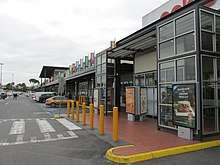
The suburb has one public school (Campbellfield Heights Primary School). There are currently no private or high schools. Campbellfield has a strip of shops on Barry Road known as Fordgate and a shopping plaza on Sydney Road.
Merlynston Creek has its source in National Boulevard Nature Reserve in Campbellfield just north of the Ford plant and next to the disused single track railway line.
Population
In the 2016 Census, there were 5,056 people in Campbellfield. 42.5% of people were born in Australia. The next most common countries of birth were Iraq 11.5%, Lebanon 8.3%, Italy 5.7%, Turkey 3.6% and Greece 2.2%. 18.2% of people spoke only English at home. Other languages spoken at home included Arabic 28.5%, Chaldean Neo-Aramaic 10.0%, Italian 7.7%, Turkish 7.3% and Greek 4.6%. The most common responses for religion were Islam 35.1% and Catholic 35.0%.[1]
Transport
The Broadmeadows Bus co is located in Campbellfield. Bus routes 530, 531, 532, 538, 540, and 902 service the area.
Railway stations that are nearest to Campbellfield are Upfield station on the Upfield line, located in nearby Upfield, and Broadmeadows station, on the Craigieburn line. There was a Campbellfield railway station, located adjacent to Camp Rd, from 1889 until 1956, when it was closed to make way for the newly built Upfield Station, which was located in a position more accessible to the community.
See also
- City of Broadmeadows - the former local government area of which Campbellfield was a part
- Campbellfield railway station
- 2019 Campbellfield factory fire
References
- Australian Bureau of Statistics (27 June 2017). "Campbellfield (State Suburb)". 2016 Census QuickStats. Retrieved 3 July 2017.

- Premier Postal History. "Post Office List". Retrieved 11 April 2008.
- http://news.theage.com.au/breaking-news-national/ford-to-cease-australian-manufacturing-20130523-2k230.html
- http://www.smh.com.au/data-point/criminal-element-taking-root-in-growth-corridors-20130331-2h1ds.html
- http://news.domain.com.au/domain/greater-melbourne/the-list-melbourne-suburbs-liveability-ranking-revealed-20111122-1nrv2.html