Burraneer, New South Wales
Burraneer is a small suburb in southern Sydney, in the state of New South Wales, Australia. Burraneer is 26 kilometres south of the Sydney central business district, in the local government area of the Sutherland Shire.
| Burraneer Sydney, New South Wales | |||||||||||||||
|---|---|---|---|---|---|---|---|---|---|---|---|---|---|---|---|
 Gunnamatta Bay, Burraneer | |||||||||||||||
| Population | 3,584 (2016 census)[1] | ||||||||||||||
| Postcode(s) | 2230 | ||||||||||||||
| Location | 26 km (16 mi) south of Sydney CBD | ||||||||||||||
| LGA(s) | Sutherland Shire | ||||||||||||||
| State electorate(s) | Cronulla | ||||||||||||||
| Federal Division(s) | Cook | ||||||||||||||
| |||||||||||||||
Burraneer sits on the peninsula of Burraneer Point, on the north shore of the Port Hacking estuary. Burraneer Bay forms the western border and Gunnamatta Bay the eastern border. Woolooware is the only adjacent suburb. Cronulla is located across Gunnamatta Bay. The suburbs of Dolans Bay, Port Hacking and Caringbah South are located across Burraneer Bay. The villages of Maianbar and Bundeena are located on the opposite bank of Port Hacking. Burraneer is a mostly residential suburb.
History
The name Burraneer Bay was recorded by surveyor Robert Dixon in 1827 as Burranear Bay, who chose many Aboriginal names for many of the bays in the area. It is popularly believed to mean point of the bay, this is probably due to an over-reading of an 1890 report by Richard Hill.[2]
In 1858 Mary and Andrew Webster paid 108 pounds and 15 shillings plus a yearly peppercorn quit rent for their land here. The Websters sold their land to Dominick Dolan in 1863. James Wilson purchased his block of 252 acres (1.0 km2) for 252 pounds in 1862. In 1866, he sold his land to Thomas Holt (1811-1888), who added it to his huge 12,000-acre (49 km2) estate that stretched from Sutherland to Cronulla.[3]
Commercial area
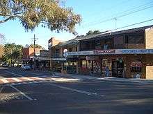
A small group of shops is located in Woolooware Road. Another group of shops is located nearby, on Burraneer Bay Road, Woolooware.
- Burraneer Bay Public School is officially located in Woolooware.
- The Royal Motor Yacht Club is located on Gunnamatta Bay.
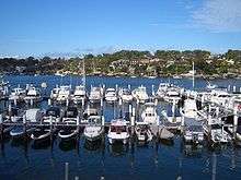
- The Burraneer Bay Marina is located on Burraneer Bay.
Demographics
According to the 2016 census of Population, there were 3,584 residents in Burraneer.
- 83.7% of people were born in Australia. The most common other countries of birth were England 3.1%, New Zealand 1.5%, Italy 0.7%, United States of America 0.6%, and Singapore 0.4%.
- 89.1% of people spoke only English at home.
- The most common responses for religion in Burraneer were Catholic 34.8%, Anglican 23.7%, No Religion 19.9%, Eastern Orthodox 4.1% and 6.9% did not state a religion.
- The average weekly household income in Burraneer was $2,860, a substantially significant inflation of 42% in comparison to the New South Wales average of $1,486. [1]
Transport
The closest railway station to Burraneer is Woolooware railway station a station on the Cronulla branch line of the Sydney Trains Eastern Suburbs & Illawarra Line or T4 line. The station like all NSW train stations is opal active. All services are double deck electric trains of eight carriages traveling to Bondi Junction stopping at major interchange stations such as Sutherland, Wolli Creek, Sydneham and Central. The station has two platforms and electronic indicator boards.
Schools
Our Lady of Mercy College, a Catholic girls' school catering to years 7 through 10, is located on Dominic Street.
Bus routes
Transdev NSW provides these bus services in the Burraneer area:-
- 971 from Cronulla to Hurstville.
- 988 from Cronulla to Caringbah (4 services a day, weekdays only Cronulla - Caringbah, 2 services a day Caringbah - Cronulla)
Sport and recreation
- Burraneer's nearest sporting club is Cronulla Seagulls FC, located in neighbouring Woolooware.
- Burraneer Bay Park has an area of bushland, a boardwalk, a playground and a bicycle/jogging track.
References
- Australian Bureau of Statistics (27 June 2017). "Burraneer (State Suburb)". 2016 Census QuickStats. Retrieved 26 October 2017.

- Burgess, Laurie (July 2020). "Sutherland Shire Origin of Suburbs". Sutherland Shire Council Spatial Services Team. p. 9f. Retrieved 12 July 2020.
- The Book of Sydney Suburbs, Compiled by Frances Pollon, Angus & Robertson Publishers, 1990, Published in Australia ISBN 0-207-14495-8, p41
| Wikimedia Commons has media related to Burraneer, New South Wales. |