Buffalo, Kansas
Buffalo is a city in Wilson County, Kansas, United States. As of the 2010 census, the city population was 232.[6]
Buffalo, Kansas | |
|---|---|
 Location within Wilson County and Kansas | |
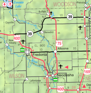 KDOT map of Wilson County (legend) | |
| Coordinates: 37°42′34″N 95°41′49″W | |
| Country | United States |
| State | Kansas |
| County | Wilson |
| Founded | 1867 |
| Incorporated | 1898 |
| Named for | American bison |
| Area | |
| • Total | 0.32 sq mi (0.82 km2) |
| • Land | 0.32 sq mi (0.82 km2) |
| • Water | 0.00 sq mi (0.00 km2) |
| Elevation | 935 ft (285 m) |
| Population | |
| • Total | 232 |
| • Estimate (2019)[3] | 209 |
| • Density | 657.23/sq mi (254.01/km2) |
| Time zone | UTC-6 (CST) |
| • Summer (DST) | UTC-5 (CDT) |
| ZIP code | 66717 |
| Area code | 620 |
| FIPS code | 20-09150 [4] |
| GNIS ID | 0474927 [5] |
History
Buffalo was founded in 1867.[7] It took its name from Buffalo Creek, which was named after the American bison, commonly known as the buffalo.[8]
The first store in Buffalo opened in 1869 and the first hotel in 1870. Buffalo experienced growth in 1886 when the Missouri Pacific Railroad was built through it.[9] Buffalo was incorporated as a city in 1898.[10]
Geography
Buffalo is located at 37°42′34″N 95°41′49″W (37.709569, -95.696967).[11] According to the United States Census Bureau, the city has a total area of 0.33 square miles (0.85 km2), all of it land.[12]
Demographics
| Historical population | |||
|---|---|---|---|
| Census | Pop. | %± | |
| 1900 | 299 | — | |
| 1910 | 807 | 169.9% | |
| 1920 | 739 | −8.4% | |
| 1930 | 799 | 8.1% | |
| 1940 | 555 | −30.5% | |
| 1950 | 437 | −21.3% | |
| 1960 | 422 | −3.4% | |
| 1970 | 321 | −23.9% | |
| 1980 | 386 | 20.2% | |
| 1990 | 293 | −24.1% | |
| 2000 | 284 | −3.1% | |
| 2010 | 232 | −18.3% | |
| Est. 2019 | 209 | [3] | −9.9% |
| U.S. Decennial Census | |||
2010 census
As of the census[2] of 2010, there were 232 people, 95 households, and 70 families residing in the city. The population density was 703.0 inhabitants per square mile (271.4/km2). There were 123 housing units at an average density of 372.7 per square mile (143.9/km2). The racial makeup of the city was 97.8% White, 0.9% Native American, and 1.3% from two or more races. Hispanic or Latino of any race were 0.9% of the population.
There were 95 households, of which 35.8% had children under the age of 18 living with them, 56.8% were married couples living together, 11.6% had a female householder with no husband present, 5.3% had a male householder with no wife present, and 26.3% were non-families. 23.2% of all households were made up of individuals, and 7.4% had someone living alone who was 65 years of age or older. The average household size was 2.44 and the average family size was 2.79.
The median age in the city was 40 years. 26.7% of residents were under the age of 18; 6.5% were between the ages of 18 and 24; 24.1% were from 25 to 44; 28.4% were from 45 to 64; and 14.2% were 65 years of age or older. The gender makeup of the city was 50.4% male and 49.6% female.
2000 census
As of the census[4] of 2000, there were 284 people, 107 households, and 78 families residing in the city. The population density was 820.7 people per square mile (313.3/km2). There were 133 housing units at an average density of 384.3 per square mile (146.7/km2). The racial makeup of the city was 96.83% White, 0.35% African American, 1.76% Native American, and 1.06% from two or more races. Hispanic or Latino of any race were 0.70% of the population.
There were 107 households, out of which 35.5% had children under the age of 18 living with them, 59.8% were married couples living together, 8.4% had a female householder with no husband present, and 27.1% were non-families. 25.2% of all households were made up of individuals, and 14.0% had someone living alone who was 65 years of age or older. The average household size was 2.65 and the average family size was 3.09.
In the city, the population was spread out, with 31.3% under the age of 18, 6.3% from 18 to 24, 26.8% from 25 to 44, 22.5% from 45 to 64, and 13.0% who were 65 years of age or older. The median age was 34 years. For every 100 females, there were 83.2 males. For every 100 females age 18 and over, there were 85.7 males.
The median income for a household in the city was $34,688, and the median income for a family was $38,750. Males had a median income of $26,750 versus $15,938 for females. The per capita income for the city was $13,529. About 6.7% of families and 7.0% of the population were below the poverty line, including 12.3% of those under the age of eighteen and 5.7% of those 65 or over.
Government
City Hall is located at 212 Buffalo Street.
Education
Buffalo is served by USD 387 Altoona-Midway. The Altoona-Midway High School mascot is Jets.[13]
Buffalo High School closed in 1958 through school unification. The Buffalo High School mascot was Pirates.[14]
Notable people
- Mel Apt, test pilot
- Claude Willoughby, baseball player
See also
References
- "2019 U.S. Gazetteer Files". United States Census Bureau. Retrieved July 24, 2020.
- "U.S. Census website". United States Census Bureau. Retrieved 2012-07-06.
- "Population and Housing Unit Estimates". United States Census Bureau. May 24, 2020. Retrieved May 27, 2020.
- "U.S. Census website". United States Census Bureau. Retrieved 2008-01-31.
- "US Board on Geographic Names". United States Geological Survey. 2007-10-25. Retrieved 2008-01-31.
- "2010 City Population and Housing Occupancy Status". U.S. Census Bureau. Retrieved January 30, 2012.
- Kansas State Historical Society (1916). Biennial Report of the Board of Directors of the Kansas State Historical Society. Kansas State Printing Plant. pp. 315.
- Duncan, L. Wallace (1902). History of Neosho and Wilson Counties, Kansas. Monitor Printing Company. p. 881.
- Duncan, L. Wallace (1902). History of Neosho and Wilson Counties, Kansas. Monitor Printing Company. p. 913.
- Blackmar, Frank Wilson (1912). Kansas: A Cyclopedia of State History, Embracing Events, Institutions, Industries, Counties, Cities, Towns, Prominent Persons, Etc. Standard Publishing Company. pp. 249.
- "US Gazetteer files: 2010, 2000, and 1990". United States Census Bureau. 2011-02-12. Retrieved 2011-04-23.
- "US Gazetteer files 2010". United States Census Bureau. Archived from the original on 2012-01-25. Retrieved 2012-07-06.
- "Altoona-Midway USD 387". USD 387. Retrieved 15 January 2017.
- "Buffalo High School". classmates.com. Retrieved 15 January 2017.
External links
- City
- Schools
- USD 387, local school district
- Maps
- Buffalo City Map, KDOT
Municipalities and communities of Wilson County, Kansas, United States | ||
|---|---|---|
| Cities | 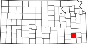 Map of Kansas highlighting Wilson County | |
| Unincorporated communities | ||
| Townships | ||
| Authority control |
|---|