Benedict, Kansas
Benedict is a city in Wilson County, Kansas, United States, along the Verdigris River. As of the 2010 census, the city population was 73.[6]
Benedict, Kansas | |
|---|---|
 Location within Wilson County and Kansas | |
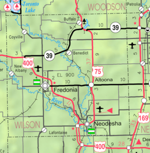 KDOT map of Wilson County (legend) | |
| Coordinates: 37°37′37″N 95°44′37″W | |
| Country | United States |
| State | Kansas |
| County | Wilson |
| Founded | 1866 |
| Incorporated | 1905 |
| Named for | S.S. Benedict |
| Area | |
| • Total | 0.15 sq mi (0.38 km2) |
| • Land | 0.15 sq mi (0.38 km2) |
| • Water | 0.00 sq mi (0.00 km2) |
| Elevation | 850 ft (260 m) |
| Population | |
| • Total | 73 |
| • Estimate (2019)[3] | 66 |
| • Density | 452.05/sq mi (174.29/km2) |
| Time zone | UTC-6 (CST) |
| • Summer (DST) | UTC-5 (CDT) |
| ZIP code | 66714 |
| Area code | 620 |
| FIPS code | 20-06000 [4] |
| GNIS ID | 0474918 [5] |
History
Benedict had its start in the year 1866 by the building of the railroad through that territory.[7] Benedict was laid out at the junction of the Atchison, Topeka and Santa Fe Railway and the Missouri Pacific Railroad.[8] It was named for S. S. Benedict.[9]
Geography
Benedict is located at 37°37′37″N 95°44′37″W (37.627014, -95.743500).[10] According to the United States Census Bureau, the city has a total area of 0.15 square miles (0.39 km2), all of it land.[11]
Climate
The climate in this area is characterized by hot, humid summers and generally mild to cool winters. According to the Köppen Climate Classification system, Benedict has a humid subtropical climate, abbreviated "Cfa" on climate maps.[12]
Demographics
| Historical population | |||
|---|---|---|---|
| Census | Pop. | %± | |
| 1910 | 215 | — | |
| 1920 | 275 | 27.9% | |
| 1930 | 223 | −18.9% | |
| 1940 | 213 | −4.5% | |
| 1950 | 176 | −17.4% | |
| 1960 | 128 | −27.3% | |
| 1970 | 91 | −28.9% | |
| 1980 | 111 | 22.0% | |
| 1990 | 16 | −85.6% | |
| 2000 | 103 | 543.8% | |
| 2010 | 73 | −29.1% | |
| Est. 2019 | 66 | [3] | −9.6% |
| U.S. Decennial Census | |||
2010 census
As of the census[2] of 2010, there were 73 people, 34 households, and 19 families residing in the city. The population density was 486.7 inhabitants per square mile (187.9/km2). There were 46 housing units at an average density of 306.7 per square mile (118.4/km2). The racial makeup of the city was 89.0% White, 2.7% Native American, 4.1% from other races, and 4.1% from two or more races. Hispanic or Latino of any race were 4.1% of the population.
There were 34 households, of which 14.7% had children under the age of 18 living with them, 44.1% were married couples living together, 5.9% had a female householder with no husband present, 5.9% had a male householder with no wife present, and 44.1% were non-families. 29.4% of all households were made up of individuals, and 20.6% had someone living alone who was 65 years of age or older. The average household size was 2.15 and the average family size was 2.74.
The median age in the city was 54.8 years. 13.7% of residents were under the age of 18; 5.4% were between the ages of 18 and 24; 19.1% were from 25 to 44; 26% were from 45 to 64; and 35.6% were 65 years of age or older. The gender makeup of the city was 50.7% male and 49.3% female.
2000 census
As of the census[4] of 2000, there were 103 people, 46 households, and 23 families residing in the city. The population density was 700.8 people per square mile (265.1/km2). There were 52 housing units at an average density of 353.8 per square mile (133.8/km2). The racial makeup of the city was 97.09% White and 2.91% Native American.
There were 46 households, out of which 23.9% had children under the age of 18 living with them, 45.7% were married couples living together, 4.3% had a female householder with no husband present, and 50.0% were non-families. 45.7% of all households were made up of individuals, and 21.7% had someone living alone who was 65 years of age or older. The average household size was 2.24 and the average family size was 3.39.
In the city, the population was spread out, with 29.1% under the age of 18, 3.9% from 18 to 24, 19.4% from 25 to 44, 31.1% from 45 to 64, and 16.5% who were 65 years of age or older. The median age was 44 years. For every 100 females, there were 94.3 males. For every 100 females age 18 and over, there were 97.3 males.
The median income for a household in the city was $20,625, and the median income for a family was $30,625. Males had a median income of $35,625 versus $16,250 for females. The per capita income for the city was $11,842. There were 19.0% of families and 27.1% of the population living below the poverty line, including 33.3% of under eighteens and 26.3% of those over 64.
Education
Benedict is served by USD 484 Fredonia.[13]
Benedict High School was closed through school unification. The Benedict High School mascot was Bulldogs.[14]
References
- "2019 U.S. Gazetteer Files". United States Census Bureau. Retrieved July 24, 2020.
- "U.S. Census website". United States Census Bureau. Retrieved 2012-07-06.
- "Population and Housing Unit Estimates". United States Census Bureau. May 24, 2020. Retrieved May 27, 2020.
- "U.S. Census website". United States Census Bureau. Retrieved 2008-01-31.
- "US Board on Geographic Names". United States Geological Survey. 2007-10-25. Retrieved 2008-01-31.
- "2010 City Population and Housing Occupancy Status". U.S. Census Bureau. Retrieved January 30, 2012.
- Duncan, L. Wallace (1902). History of Neosho and Wilson Counties, Kansas. Monitor Printing Company. p. 917.
- Blackmar, Frank Wilson (1912). Kansas: A Cyclopedia of State History, Embracing Events, Institutions, Industries, Counties, Cities, Towns, Prominent Persons, Etc. Standard Publishing Company. pp. 174.
- Duncan, L. Wallace (1902). History of Neosho and Wilson Counties, Kansas. Monitor Printing Company. p. 881.
- "US Gazetteer files: 2010, 2000, and 1990". United States Census Bureau. 2011-02-12. Retrieved 2011-04-23.
- "US Gazetteer files 2010". United States Census Bureau. Archived from the original on 2012-07-02. Retrieved 2012-07-06.
- Climate Summary for Benedict, Kansas
- "Fredonia Unified School District". USD 484. Retrieved 10 January 2017.
- "Benedict High School". E-YEARBOOK.COM. Retrieved 10 January 2017.
External links
- City
- Schools
- USD 484, local school district
- Maps
- Benedict City Map, KDOT
Municipalities and communities of Wilson County, Kansas, United States | ||
|---|---|---|
| Cities | 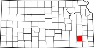 Map of Kansas highlighting Wilson County | |
| Unincorporated communities | ||
| Townships | ||