Brownsville Township, Union County, Indiana
Brownsville Township is one of six townships in Union County, Indiana, United States. As of the 2010 census, its population was 845 and it contained 351 housing units.[2]
Brownsville Township | |
|---|---|
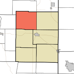 Location in Union County | |
| Coordinates: 39°41′34″N 84°58′50″W | |
| Country | United States |
| State | Indiana |
| County | Union |
| Government | |
| • Type | Indiana township |
| Area | |
| • Total | 28.54 sq mi (73.9 km2) |
| • Land | 28.39 sq mi (73.5 km2) |
| • Water | 0.15 sq mi (0.4 km2) 0.53% |
| Elevation | 791 ft (241 m) |
| Population (2010) | |
| • Total | 845 |
| • Density | 29.8/sq mi (11.5/km2) |
| Time zone | UTC-5 (Eastern (EST)) |
| • Summer (DST) | UTC-4 (EDT) |
| ZIP codes | 47325, 47353 |
| Area code(s) | 765 |
| GNIS feature ID | 453144 |
Geography
According to the 2010 census, the township has a total area of 28.54 square miles (73.9 km2), of which 28.39 square miles (73.5 km2) (or 99.47%) is land and 0.15 square miles (0.39 km2) (or 0.53%) is water.[2]
Unincorporated towns
- Brownsville at 39.6644924°N 85.0046842°W
- Clifton at 39.6903261°N 84.9557944°W
- Hopeville at 39.7014368°N 84.9705171°W
- Philomath at 39.7239361°N 85.0157959°W
- Yankee Town at 39.6956034°N 84.9855175°W
(This list is based on USGS data and may include former settlements.)
Adjacent townships
- Abington Township, Wayne County (north)
- Boston Township, Wayne County (northeast)
- Harrison Township (east)
- Center Township (southeast)
- Liberty Township (south)
- Jennings Township, Fayette County (southwest)
- Waterloo Township, Fayette County (west)
Cemeteries
The township contains these two cemeteries: Richland and Woods Chapel.
School districts
- Union County-College Corner Joint School District
Political districts
- Indiana's 6th congressional district
- State House District 55
- State Senate District 43
gollark: I would not be entirely unsurprised if the passwords weren't hashed.
gollark: Apparently someone else is "system".
gollark: Did you *Try* it on other people's?
gollark: ... is it actually *verifying* the emails you put in?
gollark: > I am an undergraduate student studying Computer Science and Social Justice.- http://falkirks.com/ (linked on the site)
References
- United States Census Bureau 2007 TIGER/Line Shapefiles
- United States Board on Geographic Names (GNIS)
- IndianaMap
- "US Board on Geographic Names". United States Geological Survey. October 25, 2007. Retrieved 2017-05-09.
- "Population, Housing Units, Area, and Density: 2010 - County -- County Subdivision and Place -- 2010 Census Summary File 1". United States Census. Archived from the original on 2020-02-12. Retrieved 2013-05-10.
External links
Municipalities and communities of Union County, Indiana, United States | ||
|---|---|---|
| Towns | Map of Indiana highlighting Union County | |
| Townships | ||
| Unincorporated communities | ||
This article is issued from Wikipedia. The text is licensed under Creative Commons - Attribution - Sharealike. Additional terms may apply for the media files.