Broome, New York
Broome is a town in Schoharie County, New York, United States. The population was 947 at the 2000 census. The town is named after John Broome.
- There is also a Broome County, New York, U.S..
Broome, New York | |
|---|---|
Town | |
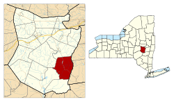 Location in Schoharie County and the state of New York. | |
| Coordinates: 42°30′33″N 74°18′26″W | |
| Country | United States |
| State | New York |
| County | Schoharie |
| Area | |
| • Total | 47.99 sq mi (124.30 km2) |
| • Land | 47.74 sq mi (123.65 km2) |
| • Water | 0.25 sq mi (0.65 km2) |
| Elevation | 1,152 ft (351 m) |
| Population (2010) | |
| • Total | 973 |
| • Estimate (2016)[2] | 970 |
| • Density | 20.32/sq mi (7.84/km2) |
| Time zone | UTC-5 (Eastern (EST)) |
| • Summer (DST) | UTC-4 (EDT) |
| FIPS code | 36-10154 |
| GNIS feature ID | 0978760 |
The Town of Broome is on the eastern border of the county, southwest of Albany.
History
The town was one of the six original towns when the county was formed in 1797. Originally named Bristol, the town name was changed to Broome in 1808. Parts of Broome town were taken to form part of Conesville town in 1836 and part of Gilboa town in 1848 and small parts annexed to Broome town from Middleburgh town in 1849.
Few settlers came to Broome until after the American Revolution.
Past residents of note
- Daniel Shays, leader of Shays' Rebellion.
- David Williams, officer involved in the capture of Major Andre.
Geography
According to the United States Census Bureau, the town has a total area of 48.1 square miles (125 km2), of which, 47.8 square miles (124 km2) of it is land and 0.3 square miles (0.78 km2) of it (0.58%) is water.
The east town line is the border of Albany County.
Catskill Creek originates in Broome.
New York State Route 145 is a north-south highway through Broome.
Demographics
| Historical population | |||
|---|---|---|---|
| Census | Pop. | %± | |
| 1800 | 1,078 | — | |
| 1810 | 1,942 | 80.1% | |
| 1820 | 2,680 | 38.0% | |
| 1830 | 3,167 | 18.2% | |
| 1840 | 2,404 | −24.1% | |
| 1850 | 2,268 | −5.7% | |
| 1860 | 2,182 | −3.8% | |
| 1870 | 1,834 | −15.9% | |
| 1880 | 1,636 | −10.8% | |
| 1890 | 1,367 | −16.4% | |
| 1900 | 1,153 | −15.7% | |
| 1910 | 933 | −19.1% | |
| 1920 | 743 | −20.4% | |
| 1930 | 650 | −12.5% | |
| 1940 | 768 | 18.2% | |
| 1950 | 635 | −17.3% | |
| 1960 | 517 | −18.6% | |
| 1970 | 551 | 6.6% | |
| 1980 | 761 | 38.1% | |
| 1990 | 926 | 21.7% | |
| 2000 | 947 | 2.3% | |
| 2010 | 973 | 2.7% | |
| Est. 2016 | 970 | [2] | −0.3% |
| U.S. Decennial Census[3] | |||
As of the census[4] of 2000, there were 947 people, 407 households, and 260 families residing in the town. The population density was 19.8 people per square mile (7.7/km2). There were 767 housing units at an average density of 16.1 per square mile (6.2/km2). The racial makeup of the town was 96.41% White, 0.74% African American, 0.32% Native American, 0.11% Asian, 0.74% from other races, and 1.69% from two or more races. Hispanic or Latino of any race were 1.80% of the population.
There were 407 households, out of which 23.8% had children under the age of 18 living with them, 53.6% were married couples living together, 5.9% had a female householder with no husband present, and 36.1% were non-families. 30.0% of all households were made up of individuals, and 12.3% had someone living alone who was 65 years of age or older. The average household size was 2.33 and the average family size was 2.91.
In the town, the population was spread out, with 20.9% under the age of 18, 5.8% from 18 to 24, 25.4% from 25 to 44, 29.4% from 45 to 64, and 18.5% who were 65 years of age or older. The median age was 44 years. For every 100 females, there were 99.8 males. For every 100 females age 18 and over, there were 103.0 males.
The median income for a household in the town was $32,368, and the median income for a family was $40,167. Males had a median income of $30,500 versus $23,750 for females. The per capita income for the town was $16,383. About 5.4% of families and 8.4% of the population were below the poverty line, including 2.5% of those under age 18 and 9.0% of those age 65 or over.
Communities and locations in Broome
- Bates (formerly "Bates Hollow") – A hamlet in the southeast part of the town.
- Franklinton (also called "The Vly") – A location in the north-central part of Broome on NY-145, south of Vlaie Pond.
- Hauversville – A hamlet near the east town line.
- Livingstonville – A hamlet in the southeast part of the town on NY-145 and Catskill Creek.
- Pine Grove – A location northwest of Hauversville.
- Vlaie Pond – A small lake in the north part of Broome.
- Vlaie Pond-Franklinton Wildlife Management Area – A conservation area by Vlai Pond.
References
- "2016 U.S. Gazetteer Files". United States Census Bureau. Retrieved Jul 5, 2017.
- "Population and Housing Unit Estimates". Retrieved June 9, 2017.
- "Census of Population and Housing". Census.gov. Retrieved June 4, 2015.
- "U.S. Census website". United States Census Bureau. Retrieved 2008-01-31.
External links
Municipalities and communities of Schoharie County, New York, United States | ||
|---|---|---|
| Villages |  Map of New York highlighting Schoharie County | |
| Towns | ||
| CDPs |
| |
| Hamlets | ||
| Authority control |
|
|---|