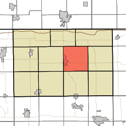
Bloomfield Township, LaGrange County, Indiana
Bloomfield Township is one of eleven townships in LaGrange County, Indiana. As of the 2010 census, its population was 5,412 and it contained 2,231 housing units.[3]
Bloomfield Township | |
|---|---|
 | |
| Coordinates: 41°38′56″N 85°21′31″W | |
| Country | United States |
| State | Indiana |
| County | LaGrange |
| Government | |
| • Type | Indiana township |
| Area | |
| • Total | 35.85 sq mi (92.9 km2) |
| • Land | 35.58 sq mi (92.2 km2) |
| • Water | 0.27 sq mi (0.7 km2) |
| Elevation | 945 ft (288 m) |
| Population (2010) | |
| • Total | 5,412 |
| • Density | 152.1/sq mi (58.7/km2) |
| FIPS code | 18-05752[2] |
| GNIS feature ID | 453113 |
Bloomfield Township was founded in 1835.[4]
Geography
According to the 2010 census, the township has a total area of 35.85 square miles (92.9 km2), of which 35.58 square miles (92.2 km2) (or 99.25%) is land and 0.27 square miles (0.70 km2) (or 0.75%) is water.[3]
gollark: Did it include some sort of secret malware, perhaps?
gollark: But why? Why would he try and scrub all trace of this version?
gollark: How mysterious.
gollark: (allegedly supposedly)
gollark: ก็็็
References
- "US Board on Geographic Names". United States Geological Survey. 2007-10-25. Retrieved 2008-01-31.
- "U.S. Census website". United States Census Bureau. Retrieved 2008-01-31.
- "Population, Housing Units, Area, and Density: 2010 - County -- County Subdivision and Place -- 2010 Census Summary File 1". United States Census. Archived from the original on 2020-02-12. Retrieved 2013-05-10.
- Counties of LaGrange and Noble, Indiana: Historical and Biographical. F.A. Battey & Company. 1882. p. 126.
External links
Municipalities and communities of LaGrange County, Indiana, United States | ||
|---|---|---|
| Towns | Map of Indiana highlighting LaGrange County | |
| Townships | ||
| CDP | ||
| Other unincorporated communities | ||
| Footnotes | ‡This populated place also has portions in an adjacent county or counties | |
This article is issued from Wikipedia. The text is licensed under Creative Commons - Attribution - Sharealike. Additional terms may apply for the media files.