Blackwater Township, Cooper County, Missouri
Blackwater Township is one of fourteen townships in Cooper County, Missouri, USA. As of the 2000 census, its population was 406.[1]
Blackwater Township | |
|---|---|
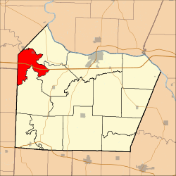 Location in Cooper County | |
| Coordinates: 38°58′05″N 92°59′39″W | |
| Country | |
| State | |
| County | Cooper |
| Area | |
| • Total | 25.26 sq mi (65.42 km2) |
| • Land | 24.88 sq mi (64.45 km2) |
| • Water | 0.37 sq mi (0.97 km2) 1.48% |
| Elevation | 636 ft (194 m) |
| Population (2000) | |
| • Total | 406 |
| • Density | 16.3/sq mi (6.3/km2) |
| Time zone | UTC-6 (CST) |
| • Summer (DST) | UTC-5 (CDT) |
| ZIP codes | 65322, 65347 |
| GNIS feature ID | 0766526 |
The township takes its name from Blackwater River.[2]
Geography
According to the United States Census Bureau, Blackwater Township covers an area of 25.26 square miles (65.42 square kilometers); of this, 24.88 square miles (64.45 square kilometers, 98.52 percent) is land and 0.37 square miles (0.97 square kilometers, 1.48 percent) is water.
Cities, towns, villages
Unincorporated towns
- Shackleford Crossing at 38.8919643°N 93.0335307°W
(This list is based on USGS data and may include former settlements.)
Adjacent townships
- Arrow Rock Township, Saline County (north)
- Lamine Township (northeast)
- Pilot Grove Township (southeast)
- Clear Creek Township (south)
- Heath Creek Township, Pettis County (southwest)
Major highways


Lakes
- Embry Lake
- Horseshoe Lake
- Wilson Lake
School districts
- Pilot Grove C-4
Political districts
- Missouri's 6th congressional district
- State House District 117
- State Senate District 21
gollark: ... yes, because that helps not spread the virus, I don't see how this somehow means that the acronym-thing everyone uses to refer to the disease caused by said virus means something else.
gollark: What?
gollark: Why would you name a *disease* that?
gollark: ... no.
gollark: Claiming it's something else isn't making a claim about the physical world or anything, but that people recognize COVID-19 as meaning a different thing, which is demonstrably false.
References
- United States Census Bureau 2008 TIGER/Line Shapefiles
- United States Board on Geographic Names (GNIS)
- United States National Atlas
- "U.S. Census website". Retrieved 2009-05-13.
- "Cooper County Place Names, 1928–1945 (archived)". The State Historical Society of Missouri. Archived from the original on 24 June 2016. Retrieved 24 September 2016.CS1 maint: BOT: original-url status unknown (link)
External links
Places adjacent to Blackwater Township, Cooper County, Missouri | |
|---|---|
Municipalities and communities of Cooper County, Missouri, United States | ||
|---|---|---|
| Cities | 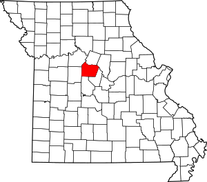 Map of Missouri highlighting Cooper County | |
| Villages | ||
| Townships | ||
| Unincorporated communities | ||
This article is issued from Wikipedia. The text is licensed under Creative Commons - Attribution - Sharealike. Additional terms may apply for the media files.