Bhurungamari Upazila
Bhurungamari (Bengali: ভুরুঙ্গামারি) is the northernmost Upazila of Kurigram District in the Division of Rangpur, Bangladesh.
Bhurungamari ভুরুঙ্গামারী | |
|---|---|
Upazila | |
 Bhurungamari Location in Bangladesh | |
| Coordinates: 26°7.5′N 89°41′E | |
| Country | |
| Division | Rangpur Division |
| District | Kurigram District |
| Area | |
| • Total | 236 km2 (91 sq mi) |
| Population (1991) | |
| • Total | 176,822 |
| • Density | 750/km2 (1,900/sq mi) |
| Time zone | UTC+6 (BST) |
| Website | Official Map of Bhurungamari |
Geography
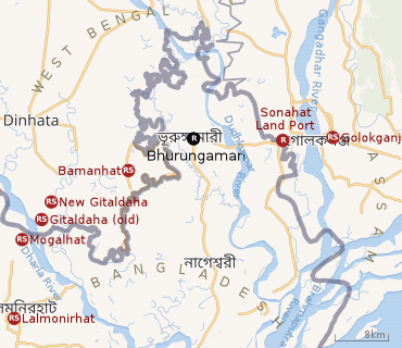 |
| Places in the south-eastern portion of Dinhata subdivision in Cooch Behar district, western part of Dhubri district, northern part of Kurigram district and northern part of Lalmonirhat district, all linked with development of railways in the area CT: census town, R: rural/ urban centre, RS: railway station Owing to space constraints in the small map, the actual locations in a larger map may vary slightly |
Bhurungamari is located at 26.1250°N 89.6833°E. It has 33984 households and total area 236 km².
Railway lnks
During the British era, there was a railway line linking Assam with Bengal that passed through Bhurngamari. The rail link was closed after the partition of India in 1947.[1]Possibilities of resumption of traffic through the Bhurugamari-Sonahat section was discussed when the resumption of rail traffic between India and Pakistan took place in 1955.[2]
Note: The map alongside presents the position as it stands today (2020). The international border was not there when the railways were first laid in the area in the 19th-20th century. It came up in 1947. Since then, it has been an effort to live up to the new realities. The map is 'interactive' (the larger version) - it means that all the places shown in the map are linked in the full screen map.
Developments
An inland port has been set up at Sonahat.[3][4]
In 2018, the existing road bridge across the Dudhkumar River was found to be weak and a new bridge was sanctioned, along with a new highway. The Kurigram (Daserhat)-Nageshwari-Bhurungamari-Sonahat Land port road is to be converted to a national highway. [1]
Demographics
As of the 1991 Bangladesh census, Bhurungamari has a population of 176822. Males constitute 50.38% of the population, and females 49.62%. This Upazila's eighteen up population is 88435. Bhurungamari has an average literacy rate of 19.5% (7+ years), and the national average of 32.4% literate.[5]
Administration
Bhurungamari has 10 Unions/Wards, 71 Mauzas/Mahallas, and 124 villages.
Best Travel Agency : Kurigram World Travel Agency Website : http://kurigramworldtravel.net
See also
References
- "Govt to build highway to boost trade thu Sonahat land port". The Daily Sun, 30 December 2018. Retrieved 1 August 2020.
- "Agreement on Resumption of Rail Traffic, 15 April 1955". Media Center, Ministry of External Affairs, Government of India. Retrieved 31 July 2020.
- "Overview" (PDF). item 11. Bangladesh Land Port Authority. Retrieved 1 August 2020.
- "বাংলাদেশ – ভারত স্থল বন্দর সমূহ এক নজরে {Bangladesh-India Land Ports At a Glance". Bengali. vromoninfo.com. Retrieved 1 August 2020.
- "Population Census Wing, BBS". Archived from the original on 2005-03-27. Retrieved November 10, 2006.
External links
- Hossain, Md Kamal (2012). "Bhurungamari Upazila". In Islam, Sirajul; Jamal, Ahmed A. (eds.). Banglapedia: National Encyclopedia of Bangladesh (Second ed.). Asiatic Society of Bangladesh.
| Upazila/Thana: | ||
|---|---|---|
Capital: Rangpur | ||
| Dinajpur District |
|  |
| Gaibandha District | ||
| Kurigram District | ||
| Lalmonirhat District | ||
| Nilphamari District | ||
| Panchagarh District | ||
| Rangpur District | ||
| Thakurgaon District | ||