Betsy Layne, Kentucky
Betsy Layne is a census-designated place (CDP) and coal town in Floyd County, Kentucky, United States. It was established in 1875 along the Levisa Fork. The post office opened on May 1, 1908, with Clayton S. Hitchins as postmaster.[1] Its ZIP code is 41605. The 2010 census reported the population to be 688.[2] Stage actress Bette Henritze (born 1924) is a native of Betsy Layne.
Betsy Layne, Kentucky | |
|---|---|
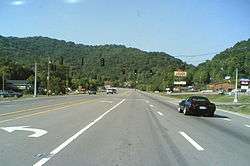
 U.S. 23 in Betsy Layne | |
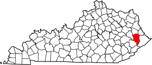
 Betsy Layne Location within the state of Kentucky | |
| Coordinates: 37°33′05″N 82°38′01″W | |
| Country | United States |
| State | Kentucky |
| County | Floyd |
| Settled | 1875 |
| Area | |
| • Total | 1.84 sq mi (4.76 km2) |
| • Land | 1.81 sq mi (4.69 km2) |
| • Water | 0.03 sq mi (0.07 km2) |
| Elevation | 650 ft (200 m) |
| Population (2010) | |
| • Total | 688 |
| • Density | 380/sq mi (146.8/km2) |
| Time zone | UTC-5 (Eastern (EST)) |
| • Summer (DST) | UTC-4 (EDT) |
| ZIP code | 41605 |
| FIPS code | 21-06220 |
| GNIS feature ID | 487043 |
Betsy Layne is located along the eastern border of Floyd County at 37°33′05″N 82°38′01″W (37.5514880, -82.6334884) and at an elevation of 650 ft (198 m).[3] It is bordered to the east by Pike County. U.S. Route 23 passes through the community, leading northwest 13 miles (21 km) to Prestonsburg and southeast 12 miles (19 km) to Pikeville.
Notable people
- Natasha Cornett – murderer sentenced to life imprisonment for the Lillelid murders<ef>https://www.tncourts.gov/sites/default/files/OPINIONS/tcca/PDF/001/howelletal.pdf</ref>
gollark: Presumably, stays stable even if heated.
gollark: Or things which might be bad eventually but aren't immediately.
gollark: Maybe a lot of effort gets put into pandemic preparation in the near-term after COVID, possibly too much, and then another pandemic doesn't immediately happen and people get bored and do something else.
gollark: I kind of worry that people are not going to actually prepare very well in the long term.
gollark: People will turn any badness into a meme!
References
- Rennick, Robert M. (1988). "Place Names". Kentucky Place Names. Lexington, Kentucky: The University Press of Kentucky. ISBN 0-8131-0179-4. Retrieved on 2010-12-06
- "Geographic Identifiers: 2010 Census Summary File 1 (G001), Betsy Layne CDP, Kentucky". American FactFinder. U.S. Census Bureau. Archived from the original on February 13, 2020. Retrieved May 23, 2016.
- "Betsy Layne, Kentucky". Geographic Names Information System. United States Geological Survey. Retrieved on 2010-12-06
This article is issued from Wikipedia. The text is licensed under Creative Commons - Attribution - Sharealike. Additional terms may apply for the media files.
