Beresford Parish, New Brunswick
Beresford is a civil parish[lower-alpha 1] in Gloucester County, New Brunswick, Canada. For governance purposes it is divided between the town of Beresford; the villages of Belledune, Nigadoo, Petit-Rocher, and Pointe-Verte; and the local service districts of Dunlop, Laplante,[lower-alpha 2] Madran, Petit-Rocher-Nord (Devereaux), Petit-Rocher-Sud, Robertville, Tremblay, and the parish of Beresford, which in turn includes the special service areas of Alcida and Dauversière; Nicholas-Denys, Free Grant and Sainte-Rosette; Petit Rocher West[lower-alpha 3]; Saint-Laurent Nord; Sainte-Louise; Sainte-Thérèse Sud; and Sormany.[lower-alpha 4]
Beresford | |
|---|---|
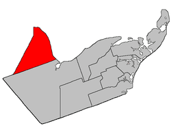 Location within Gloucester County, New Brunswick | |
| Coordinates: 47.715°N 65.8875°W | |
| Country | |
| Province | |
| County | Gloucester |
| Established | 1814 |
| Area | |
| • Land | 456.86 km2 (176.39 sq mi) |
| Population (2016)[1] | |
| • Total | 6,248 |
| • Density | 13.7/km2 (35/sq mi) |
| • Change 2011-2016 | |
| • Dwellings | 2,780 |
| Time zone | UTC-4 (AST) |
| • Summer (DST) | UTC-3 (ADT) |
Delineation
Beresford Parish is defined in the Territorial Division Act[3] as being bounded:
- West by the County line; east by the Chaleur Bay and south by the easterly prolongation of the south line of Restigouche County.
Communities
Parish population total does not include incorporated municipalities (in bold):
|
|
|
Demographics
Population
| Canada census – Beresford Parish, New Brunswick community profile | |||
|---|---|---|---|
| 2016 | 2011 | 2006 | |
| Population: | 6,248 (-1.7% from 2011) | 6,354 (+0.8% from 2006) | 6,301 (-4.8% from 2001) |
| Land area: | 456.86 km2 (176.39 sq mi) | 456.75 km2 (176.35 sq mi) | 455.93 km2 (176.04 sq mi) |
| Population density: | 13.7/km2 (35/sq mi) | 13.9/km2 (36/sq mi) | 13.8/km2 (36/sq mi) |
| Median age: | 49.1 (M: 49.2, F: 48.9) | 46.0 (M: 46.1, F: 46.0) | 42.4 (M: 42.6, F: 42.2) |
| Total private dwellings: | 2,780 | 2,730 | 2,633 |
| Median household income: | $57,968 | $53,109 | $45,901 |
| References: 2016[4] 2011[5] 2006[6] earlier[7] | |||
|
|
| |||||||||||||||||||||||||||
| [8][1] | |||||||||||||||||||||||||||||
Language
| Canada Census Mother Tongue - Beresford Parish, New Brunswick[8] | ||||||||||||||||||
|---|---|---|---|---|---|---|---|---|---|---|---|---|---|---|---|---|---|---|
| Census | Total | French |
English |
French & English |
Other | |||||||||||||
| Year | Responses | Count | Trend | Pop % | Count | Trend | Pop % | Count | Trend | Pop % | Count | Trend | Pop % | |||||
2011 |
6,275 |
5,755 | 91.71% | 435 | 6.93% | 60 | 0.96% | 25 | 0.40% | |||||||||
2006 |
6,205 |
5,575 | 89.85% | 475 | 7.65% | 95 | 1.53% | 60 | 0.97% | |||||||||
2001 |
6,520 |
5,925 | 90.87% | 500 | 7.67% | 75 | 1.15% | 20 | 0.31% | |||||||||
1996 |
6,785 |
6,155 | n/a | 90.71% | 570 | n/a | 8.40% | 50 | n/a | 0.74% | 10 | n/a | 0.15% | |||||
Access Routes
Highways and numbered routes that run through the parish, including external routes that start or finish at the parish limits:[9]
|
|
|
|
See also
Notes
- Civil parishes served a variety of government functions until 1966, when the new Municipalities Act stripped them of their responsibilities; parishes continue to provide convenient boundaries for federal and provincial electoral districts. Statistics Canada uses civil parishes as census subdivisions for all parts of the province that are not within municipalities and similar entities.
- The LSD's name does not use an uppercase P.
- More commonly known by its French form Petit-Rocher-Ouest.
- The Taxing Authorities of the parish of Beresford LSD are Beresford (Alcida & Dauversière), Beresford (Nicholas-Denys), Beresford (Nord), Beresford (Petit Rocher West), Beresford (Saint-Laurent), and Beresford (Sud).[2]
References
- "Census Profile, 2016 Census: Beresford, Parish [Census subdivision], New Brunswick". Statistics Canada. Retrieved September 9, 2019.
- "2019 Local Government Statistics for New Brunswick" (PDF). Department of Environment and Local Government. p. 59. Retrieved 8 July 2020.
- "Territorial Division Act (R.S.N.B. 1973, c. T-3)". Government of New Brunswick website. Retrieved 17 August 2016.
- "2016 Community Profiles". 2016 Canadian Census. Statistics Canada. February 21, 2017. Retrieved 2019-09-09.
- "2011 Community Profiles". 2011 Canadian Census. Statistics Canada. July 5, 2013. Retrieved 2014-03-30.
- "2006 Community Profiles". 2006 Canadian Census. Statistics Canada. March 30, 2011. Retrieved 2014-03-30.
- "2001 Community Profiles". 2001 Canadian Census. Statistics Canada. February 17, 2012.
- Statistics Canada: 1996, 2001, 2006, 2011 census
- Atlantic Canada Back Road Atlas ISBN 978-1-55368-618-7 Page 7
Places adjacent to Beresford Parish, New Brunswick | ||||||||||
|---|---|---|---|---|---|---|---|---|---|---|
| ||||||||||
| Subdivisions |
|
|---|---|
| Cities | |
| Counties | |
| |