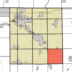
Benton Township, Elkhart County, Indiana
Benton Township is one of sixteen townships in Elkhart County, Indiana. As of the 2010 census, its population was 2,963.[3]
Benton Township | |
|---|---|
 Location of Benton Township in Elkhart County | |
| Coordinates: 41°28′55″N 85°42′27″W | |
| Country | United States |
| State | Indiana |
| County | Elkhart |
| Government | |
| • Type | Indiana township |
| Area | |
| • Total | 35.9 sq mi (93 km2) |
| • Land | 35.84 sq mi (92.8 km2) |
| • Water | 0.06 sq mi (0.2 km2) |
| Elevation | 853 ft (260 m) |
| Population (2010) | |
| • Total | 2,963 |
| • Density | 82.7/sq mi (31.9/km2) |
| FIPS code | 18-04798[2] |
| GNIS feature ID | 453105 |
Geography
According to the 2010 census, the township has a total area of 35.9 square miles (93 km2), of which 35.84 square miles (92.8 km2) (or 99.83%) is land and 0.06 square miles (0.16 km2) (or 0.17%) is water.[3]
Cities and towns
- Millersburg (south quarter)
Unincorporated towns
Adjacent townships
- Clinton Township (north)
- Eden Township, LaGrange County (northeast)
- Perry Township, Noble County (east)
- Sparta Township, Noble County (southeast)
- Turkey Creek Township, Kosciusko County (south)
- Van Buren Township, Kosciusko County (southwest)
- Jackson Township (west)
- Elkhart Township (northwest)
Cemeteries
The township contains two cemeteries: Brown and Hire.
gollark: But implementing page aliases and better link case insensitivity would be quite difficult and either be slow or require two pass rendering.
gollark: Anyway, running minoteaur ""at scale"" has shown me that people actually do want "index/recent changes/general purpose discovery thing", so I need to work out how to do that decently, and also the case-insensitivity thing works poorly in some situations and people want aliases/redirects.
gollark: Fascinating.
gollark: It would be unethical (due to endianness apioforms) to just *cast* it.
gollark: It seems to be something something unpacking integer from array of bytes.
References
- "Benton Township, Elkhart County, Indiana". Geographic Names Information System. United States Geological Survey. Retrieved 2009-09-24.
- United States Census Bureau cartographic boundary files
- "US Board on Geographic Names". United States Geological Survey. 2007-10-25. Retrieved 2008-01-31.
- "U.S. Census website". United States Census Bureau. Retrieved 2008-01-31.
- "Population, Housing Units, Area, and Density: 2010 - County -- County Subdivision and Place -- 2010 Census Summary File 1". United States Census. Archived from the original on 2020-02-12. Retrieved 2013-05-10.
This article is issued from Wikipedia. The text is licensed under Creative Commons - Attribution - Sharealike. Additional terms may apply for the media files.