Belt Creek (Montana)
Belt Creek (Gros Ventre: kɔyɔ́ɔteihíniicááh, lit. 'belt river'[3]) is a tributary, approximately 80 mi (129 km) long, of the Missouri River in western Montana in the United States.
| Belt Creek | |
|---|---|
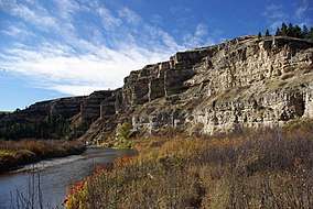 Belt Creek flowing below the cliffs of Sluice Boxes State Park | |
 Mouth of Belt Creek in Montana | |
| Native name | kɔyɔ́ɔteihíniicááh |
| Location | |
| Country | Cascade and Chouteau County, Montana |
| Physical characteristics | |
| Source | |
| • coordinates | 46°50′45″N 110°40′09″W[1] |
| Mouth | |
• coordinates | 47°35′53″N 111°02′55″W[1] |
• elevation | 2,792 feet (851 m)[1] |
| Discharge | |
| • location | near Portage |
| • average | 249 cu ft/s (7.1 m3/s)[2] |
| Basin features | |
| River system | Missouri River |
It originates in the Lewis and Clark National Forest north of Big Baldy Mountain, in the Little Belt Mountains in western Judith Basin County. It flows northwest through mountainous canyons (Limestone Canyon) past Monarch, through Sluice Boxes State Park, and flows through Armington and Belt. It finally joins the Missouri approximately 15 mi (25 km) northwest of Great Falls of the Missouri.
It is named for the Little Belt Mountains, which it flows through.[3]
Notes
- "Belt Creek". Geographic Names Information System. United States Geological Survey.
- "USGS Surface-Water Annual Statistics for Montana: Belt Creek near Portage MT". Retrieved June 13, 2020.
- Cowell, A.; Taylor, A.; Brockie, T. "Gros Ventre ethnogeography and place names: A diachronic perspective". Anthropological Linguistics. 58 (2): 132–170. doi:10.1353/anl.2016.0025.

This article is issued from Wikipedia. The text is licensed under Creative Commons - Attribution - Sharealike. Additional terms may apply for the media files.