Bayou L'Ourse, Louisiana
Bayou L'Ourse is a census-designated place (CDP) in Assumption Parish, Louisiana, United States. The population was 1,978 at the 2010 census.[1]
Bayou L'Ourse, Louisiana | |
|---|---|
 Bayou L'Ourse, Louisiana Location of Bayou L'Ourse in Louisiana | |
| Coordinates: 29°43′18″N 91°03′28″W | |
| Country | United States |
| State | Louisiana |
| Parish | Assumption |
| Area | |
| • Total | 2.7 sq mi (7.1 km2) |
| Elevation | 5 ft (2 m) |
| Population (2010) | |
| • Total | 1,978 |
| • Density | 720/sq mi (280/km2) |
| Time zone | UTC-6 (CST) |
| • Summer (DST) | UTC-5 (CDT) |
| Area code(s) | 985 |
Geography
Bayou L'Ourse is located at 29°43′18″N 91°3′28″W,[2] located between the Intracoastal Waterway in lower Assumption Parish North along Hwy 662 to Bayou Cheramie on Hwy 398. It is 12 miles (19 km) east of Morgan City 18 miles (29 km) west of Thibodaux and 10 miles (16 km) South of Labadieville.
According to the United States Census Bureau, the CDP has a total area of 2.7 square miles (7.1 km2),[1]
gollark: GTech™'s assemblers can make them.
gollark: Hover BOOTS.
gollark: Ah, 400 CPU-millisecond-Hz on iowait.
gollark: We use good ones, actually.
gollark: Maybe your *bad* hypercomputers™.
References
- "Geographic Identifiers: 2010 Demographic Profile Data (G001): Bayou L'Ourse CDP, Louisiana". U.S. Census Bureau, American Factfinder. Archived from the original on February 12, 2020. Retrieved May 15, 2013.
- "US Gazetteer files: 2010, 2000, and 1990". United States Census Bureau. 2011-02-12. Retrieved 2011-04-23.
Municipalities and communities of Assumption Parish, Louisiana, United States | ||
|---|---|---|
Parish seat: Napoleonville | ||
| Village | 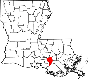 | |
| CDPs |
| |
| Other unincorporated communities |
| |
This article is issued from Wikipedia. The text is licensed under Creative Commons - Attribution - Sharealike. Additional terms may apply for the media files.