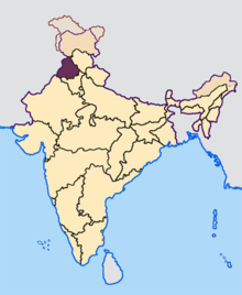
Bathinda district
Bathinda district is in Malwa region of Punjab, India. The districts encompass an area of 3,385 square kilometers. According to the area, Bathinda District is the third-largest in Punjab (after Ludhiana District and Sangrur District). It is bounded by Faridkot district and Moga district on the north, Mukatsar district on the west, Barnala and Mansa districts on the east, and the state of Haryana on the south. Bathinda is cotton producing belt of Punjab.
Bathinda district | |
|---|---|
District | |
 Bathinda fort | |
 Districts of Punjab along with their headquarters | |
| Coordinates: 30°12′36″N 74°56′24″E | |
| Country | |
| State | Punjab |
| District | Bathinda |
| Region of Punjab | Malwa |
| Population (2011)[1] | |
| • District | 1,388,525 |
| • Metro | 1,183,705 |
| Languages | |
| • Official | Punjabi |
| Time zone | UTC+5:30 (IST) |
| PIN | 151001 |
| Telephone code | 0164 |
| Website | www |
History
The district of Bathinda came into existence with the formation of the PEPSU in 1948. It had its headquarters at Faridkot, which were shifted to Bathinda in 1952.
| Year | Pop. | ±% p.a. |
|---|---|---|
| 1951 | 377,757 | — |
| 1961 | 509,031 | +3.03% |
| 1971 | 623,172 | +2.04% |
| 1981 | 817,764 | +2.75% |
| 1991 | 985,301 | +1.88% |
| 2001 | 1,183,295 | +1.85% |
| 2011 | 1,388,525 | +1.61% |
| source:[3] | ||
Demography
According to the 2011 census Bathinda district has a population of 1,388,525,[5] roughly equal to the nation of Swaziland[6] or the US state of Hawaii.[7] This gives it a ranking of 352nd in India (out of a total of 640).[5] The district has a population density of 414 inhabitants per square kilometre (1,070/sq mi) .[5] Its population growth rate over the decade 2001–2011 was 17.37%.[5] Bathinda has a sex ratio of 865 females for every 1000 males,[5] and a literacy rate of 69.6%.[5]
Administration
| Bathinda | ||||||||||||||||||||||||||||||||||||||||||||||||||||||||||||
|---|---|---|---|---|---|---|---|---|---|---|---|---|---|---|---|---|---|---|---|---|---|---|---|---|---|---|---|---|---|---|---|---|---|---|---|---|---|---|---|---|---|---|---|---|---|---|---|---|---|---|---|---|---|---|---|---|---|---|---|---|
| Climate chart (explanation) | ||||||||||||||||||||||||||||||||||||||||||||||||||||||||||||
| ||||||||||||||||||||||||||||||||||||||||||||||||||||||||||||
| ||||||||||||||||||||||||||||||||||||||||||||||||||||||||||||
Bathinda is divided into the 4 tehsils of Bathinda, Rampura Phul, Maur and Talwandi Sabo. These tehsils are further divided into the nine blocks of Bathinda, Sangat, Nathana, Rampura, Phul, Maur, Balianwali, Bhagta Bhai ka and Talwandi Sabo.[8]
| Administrative Structure | ||||
|---|---|---|---|---|
| No of Blocks | No of Villages | No of Census town | No of M.Corporation | No of M. Councils |
| 9 (Bathinda, Sangat, Nathana, Rampura, Phul, Maur, Balianwali, Bhagta Bhaika and Talwandisabo) | 272 | 2 (Bhisiana, Mehna) | 1 (Bathinda) | 20 (Sangat, Raman Mandi, Maur, Kotfatta, Rampura, Bhuchomandi, Goniana, Talwandi sabo, Bhagta, Kotshamir, Lehra Mohabbat, Nathana, Chauke, Rampura, Balianwali, Mandi Kalan, Maluka, Kothaguru, Bhairupa, Mehraj ) |
See also
References
- "Provisional Population Totals, Census of India 2011; Cities having population 1 lakh and above" (PDF). Office of the Registrar General & Census Commissioner, India. Retrieved 26 March 2012.
- "Provisional Population Totals, Census of India 2011; Urban Agglomerations/Cities having population 1 lakh and above" (PDF). Office of the Registrar General & Census Commissioner, India. Retrieved 26 March 2012.
- Decadal Variation In Population Since 1901
- Bathinda District Population Census 2011, Punjab literacy sex ratio and density. Census2011.co.in. Retrieved on 18 October 2015.
- "District Census 2011". Census2011.co.in. 2011. Retrieved 30 September 2011.
- US Directorate of Intelligence. "Country Comparison:Population". Retrieved 1 October 2011.
Swaziland 1,370,424
- "2010 Resident Population Data". U. S. Census Bureau. Archived from the original on 19 October 2013. Retrieved 30 September 2011.
Hawaii 1,360,301
- District at A glance Archived 10 January 2011 at the Wayback Machine. Bathinda.nic.in. Retrieved on 18 October 2015.
External links
| Wikimedia Commons has media related to Bathinda district. |
| Wikivoyage has a travel guide for Bathinda district. |
