Asuncion Island
Asuncion (or Ascuncion) (from Spanish meaning "assumption") is the third northernmost island in the Northern Mariana Islands chain in the Pacific Ocean. The island is uninhabited. Asuncion is situated 101 kilometers (63 mi) northwest of Agrihan and 37 km (23 mi) southeast of the Maug Islands.[1]
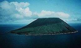
 US Geological survey photo of Asuncion island | |
| Geography | |
|---|---|
| Location | Pacific Ocean |
| Coordinates | 19°41′33″N 145°24′13″E |
| Archipelago | Northern Mariana Islands |
| Area | 7.9 km2 (3.1 sq mi) |
| Length | 3.3 km (2.05 mi) |
| Width | 3 km (1.9 mi) |
| Highest elevation | 857 m (2,812 ft) |
| Highest point | Mount Asuncion |
| Administration | |
United States | |
| Commonwealth | Northern Mariana Islands |
| Demographics | |
| Population | 0 (2010) |
Geography
Asuncion is a densely forested island, roughly elliptical in shape, with a length of 3.3 kilometers (2.1 mi) and a width of 3 km (1.9 mi) and an area of 7.9 km2 (3.1 sq mi). The entire island is a massive stratovolcano which rises from the ocean floor to a height of 857 m (2,812 ft) above sea level,[2] which last erupted in 1906.
The volcano is asymmetrical, with steep northeast slopes terminating in high cliffs. The southwestern slopes are shallower and meet the sea in low cliffs. Coastlines are generally rocky. Vegetation includes Swordgrass (Miscanthus floridulus) grasslands on the upper slopes, forests of Coconut Palm (Cocos nucifera), with some Pandanus trees and Papaya (Carica papaya) on the lower slopes, along with native Pisonia.
History
From a European perspective Asuncion was discovered in 1669 by the Spanish missionary Diego Luis de San Vitores who gave it its present name (Assumption of Mary in Spanish). It is likely that it was previously visited in 1522 by the Spanish sailor Gonzalo de Vigo, deserter from the Magellan expedition in 1521, and also the first European castaway in the history of the Pacific.[3] In 1695, the native Chamorros were forcibly removed to Saipan, and three years later to Guam.
Following the sale of the Northern Marianas by Spain to the German Empire in 1899, Asuncion was administered as part of German New Guinea. In 1903, the island was leased to a Japanese company, who hunted birds for feathers for export to Japan, and from there to Paris. Six Japanese hunters died on the island in 1910 from illness.
During World War I, Asuncion came under the control of the Empire of Japan and was administered as the South Pacific Mandate. Following World War II, the island came under the control of the United States and was administered as part of the Trust Territory of the Pacific Islands. Since 1978, the island has been part of the Northern Islands Municipality of the Commonwealth of the Northern Mariana Islands.
In 1985, per the Constitution of the Commonwealth of the Northern Mariana Islands, the island was designated as a wilderness area for the protection and conservation of natural resources. Since 2009, the island has been part of Marianas Trench Marine National Monument of the United States.
See also
References
- "Mariana Islands - Asuncion". 2009-07-07. Archived from the original on 2009-07-07. Retrieved 2019-07-10.
- "Asuncion". Global Volcanism Program. Smithsonian Institution.
- Coello, Francisco "Conflicto hispano-alemán" Boletín de Sociedad Geográfica de Madrid, t.XIX. 2º semestre 1885, Madrid, p.233,301.
External links
| Wikimedia Commons has media related to Asuncion Island. |
- "oceandots.com". Archived from the original on 2010-12-23. Retrieved 2009-03-14.CS1 maint: BOT: original-url status unknown (link)
- UN earthwatch info on island
- Pascal Horst Lehne and Christoph Gäbler: Über die Marianen. Lehne-Verlag, Wohldorf in Germany 1972.
- Volcanism
