Kamerun
Kamerun was an African colony of the German Empire from 1884 to 1916 in the region of today's Republic of Cameroon. Kamerun also included northern parts of Gabon and the Congo with western parts of the Central African Republic, southwestern parts of Chad and far eastern parts of Nigeria.
Kamerun | |||||||||||||||||||
|---|---|---|---|---|---|---|---|---|---|---|---|---|---|---|---|---|---|---|---|
| 1884–1916 | |||||||||||||||||||
 Flag
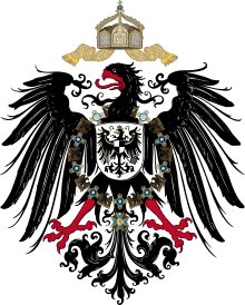 Coats of arms
| |||||||||||||||||||
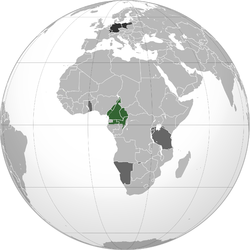 Historical German territory projected onto a modern-day globe: Green: Territory comprising German colony of Kamerun Dark grey: Other German territories Darkest grey: German Empire | |||||||||||||||||||
| Status | German colony | ||||||||||||||||||
| Common languages | German (official) | ||||||||||||||||||
| Government | Colony | ||||||||||||||||||
| Governor | |||||||||||||||||||
• 1884 | Gustav Nachtigal | ||||||||||||||||||
• 1887–1906 | Jesko von Puttkamer | ||||||||||||||||||
• 1914–1916 | Karl Ebermaier | ||||||||||||||||||
| History | |||||||||||||||||||
• Established | 1884 | ||||||||||||||||||
• Disestablished | 1916 | ||||||||||||||||||
| Currency | German gold mark | ||||||||||||||||||
| |||||||||||||||||||
| Today part of | |||||||||||||||||||
History
19th century
The first German trading post in the Duala area (present-day Douala) on the Kamerun River delta (present-day Wouri River delta) was established in 1868 by the Hamburg trading company C. Woermann. The firm's agent in Gabon, Johannes Thormählen, expanded activities to the Kamerun River delta. In 1874, together with the Woermann agent in Liberia, Wilhelm Jantzen, the two merchants founded their own company, Jantzen & Thormählen there.
Both of these West Africa houses expanded into shipping with their own sailing ships and steamers and inaugurated scheduled passenger and freight service between Hamburg, Germany and Duala.[1] These companies and others obtained extensive acreage from local chiefs and began systematic plantation operations, including bananas.
By 1884, Adolph Woermann, representing all West African companies as their spokesman, petitioned the imperial foreign office for "protection" by the German Empire. Bismarck, the Imperial Chancellor, sought to utilize the traders on site in governing the region via "chartered companies". However, in response to Bismarck's proposal, the companies withdrew their petition.[2]
At the core of the commercial interests was pursuit of profitable trading activities under the protection of the Reich, but these entities were determined to stay away from political engagements. Eventually, Bismarck yielded to the Woermann position and instructed the admiralty to dispatch a gunboat. As a show of German interest, the small gunboat SMS Möwe arrived in West Africa.[3]
Germany was particularly interested in Cameroon's agricultural potential and it was entrusted to large firms to exploit and export it. Chancellor Bismarck defined the order of priorities as follows: "first the merchant, then the soldier". It was under the influence of businessman Adolph Woermann, whose company set up a trading house in Douala, that Bismarck, initially skeptical about the interest of the colonial project, was convinced. Large German trading companies (Woermann, Jantzen und Thoermalen) and concession companies (Sudkamerun Gesellschaft, Nord-West Kamerun Gesellschaft) established themselves massively in the colony. Letting the big companies impose their order, the administration simply supported them, protected them and eliminated native uprisings.[4]
Germany was planning to build a great African empire, which would connect Kamerun through the Congo to its East African possessions. The German Foreign Minister said shortly before the First World War that the Belgian Congo was too large a colony for a country too small.
Protectorate of Cameroon
The protectorate of Cameroon was established during the period generally known as Europe's imperial "Scramble for Africa". The German explorer, medical doctor, imperial consul and commissioner for West Africa, Gustav Nachtigal, was the driving force toward the colony's establishment. By then well over a dozen German companies, based in Hamburg and Bremen, conducted trading and plantation activities in Cameroon.[5]
20th century
With imperial treasury subsidies, the colony built two rail lines from the port city of Duala to bring agricultural products to market: the Northern line of 160-kilometre (99 mi) to the Manenguba mountains, and the 300-kilometre (190 mi) long mainline to Makak on the river Nyong.[6] An extensive postal and telegraph system and a river navigation network with government ships connected the coast to the interior.
The Cameroon protectorate was enlarged with New Cameroon (German: Neukamerun) in 1911 as part of the settlement of the Agadir Crisis, resolved by the Treaty of Fez.
German losses
At the outbreak of World War I, French, Belgian and British troops invaded the German colony in 1914 and fully occupied it during the Kamerun campaign. The last German fort to surrender was the one at Mora in the north of the colony in 1916.
Following Germany's defeat, the Treaty of Versailles divided the territory into two League of Nations mandates (Class B) under the administration of Great Britain and France. French Cameroun and part of British Cameroons reunified in 1961 as Cameroon.
Gallery
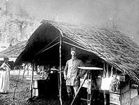 German surveyor in Kamerun, 1884
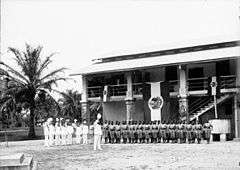 Policemen at Duala on the Kaiser's birthday, 1901
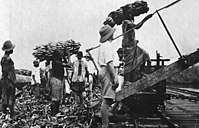 Bananas being loaded for export to Germany, 1912
Governors
Planned symbols for Kamerun
In 1914 a series of drafts were made for proposed Coat of Arms and Flags for the German Colonies. However, World War I broke out before the designs were finished and implemented and the symbols were never actually taken into use. Following the defeat in the war, Germany lost all its colonies and the prepared coat of arms and flags were therefore never used.
 Proposed flag
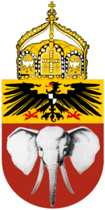 Proposed coat of arms
See also
- German West African Company
- History of Cameroon
- New Cameroon
- Index: German colonisation in Africa
- German South West Africa
- Togoland
- German East Africa
- Elo Sambo
- Kamerun Campaign
Footnotes
- Washausen, Hamburg und die Kolonialpolitik, p. 68
- Washausen, p. 116
- Haupt, Deutschlands Schutzgebiete, p. 57
- Thomas Deltombe, Manuel Domergue, Jacob Tatsita, KAMERUN !, La Découverte, 2019
- By 1911 the total volume of trade reached over 50 million gold marks [Haupt, p. 64].
- This line was later extended to the current Cameroon capital of Yaoundé.
Bibliography and references
- DeLancey, Mark W.; DeLancey, Mark D. (2000). Historical Dictionary of the Republic of Cameroon (3rd ed.). Lanham, Maryland: The Scarecrow Press. ISBN 0-8108-3775-7. OCLC 43324271.
- Gorges, E. Howard (1923). The Great War in West Africa. London: Hutchinson & Co.
- Haupt, Werner (1984). Deutschlands Schutzgebiete in Übersee 1884–1918 [Germany’s Overseas Protectorates 1884–1918]. Friedberg: Podzun-Pallas Verlag. ISBN 3-7909-0204-7.
- Hoffmann, Florian (2007). Okkupation und Militärverwaltung in Kamerun. Etablierung und Institutionalisierung des kolonialen Gewaltmonopols. Göttingen: Cuvillier Verlag. ISBN 9783867274722.
- "German Cameroons 1914". UniMaps. 2004. Archived from the original on 4 April 2013. Map of the territories exchanged between France and Germany at the Treaty of Fez.
- Schaper, Ulrike (2012). Koloniale Verhandlungen. Gerichtsbarkeit, Verwaltung und Herrschaft in Kamerun 1884-1916. Frankfurt am Main 2012: Campus Verlag. ISBN 3-593-39639-4.CS1 maint: location (link)
- Washausen, Helmut (1968). Hamburg und die Kolonialpolitik des Deutschen Reiches 1880 bis 1890 [Hamburg and Colonial Politics of the German Empire]. Hamburg: Hans Christians Verlag. OCLC 186017338.