Asbury Township, Gallatin County, Illinois
Asbury Township is one of ten townships in Gallatin County, Illinois, USA. As of the 2010 census, its population was 105 and it contained 51 housing units.[2]
Asbury Township | |
|---|---|
 Wheat harvest along New Haven-Shawneetown Road | |
 Location in Gallatin County | |
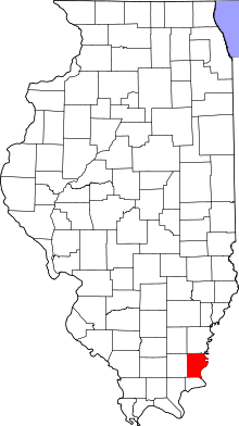 Gallatin County's location in Illinois | |
| Coordinates: 37°53′16″N 88°12′45″W | |
| Country | United States |
| State | Illinois |
| County | Gallatin |
| Established | November 5, 1890 |
| Area | |
| • Total | 17.82 sq mi (46.2 km2) |
| • Land | 17.79 sq mi (46.1 km2) |
| • Water | 0.03 sq mi (0.08 km2) 0.17% |
| Elevation | 410 ft (125 m) |
| Population (2010) | |
| • Estimate (2016)[1] | 99 |
| • Density | 5.9/sq mi (2.3/km2) |
| Time zone | UTC-6 (CST) |
| • Summer (DST) | UTC-5 (CDT) |
| ZIP codes | 62867, 62871 |
| FIPS code | 17-059-02427 |
Geography
According to the 2010 census, the township has a total area of 17.82 square miles (46.2 km2), of which 17.79 square miles (46.1 km2) (or 99.83%) is land and 0.03 square miles (0.078 km2) (or 0.17%) is water.[2]
Unincorporated towns
(This list is based on USGS data and may include former settlements.)
Cemeteries
The township contains these two cemeteries: Cottonwood Presbyterian Church and Swan.
School districts
- Gallatin Community Unit School District 7
Political districts
- Illinois' 15th congressional district
- State House District 118
- State Senate District 59
gollark: The servers will transfer data between themselves.
gollark: It ought to be okay. Basically, each socket gets an ID, and each client should only be connected to one server.
gollark: Does it need to do anything other than just exchange messages which you can think of?
gollark: I'm currently working on a skynet logs viewer, and will do federation stuff afterwards.
gollark: I wanted it to work on nodejs without precompilation.
References
- "Asbury Township, Gallatin County, Illinois". Geographic Names Information System. United States Geological Survey. Retrieved 2010-01-17.
- United States Census Bureau 2007 TIGER/Line Shapefiles
- United States National Atlas
- "Population and Housing Unit Estimates". Retrieved June 9, 2017.
- "Population, Housing Units, Area, and Density: 2010 - County -- County Subdivision and Place -- 2010 Census Summary File 1". United States Census. Archived from the original on 2020-02-12. Retrieved 2013-05-28.
- "Census of Population and Housing". Census.gov. Retrieved June 4, 2016.
External links
Places adjacent to Asbury Township, Gallatin County, Illinois | |
|---|---|
Municipalities and communities of Gallatin County, Illinois, United States | ||
|---|---|---|
| City | Map of Illinois highlighting Gallatin County | |
| Villages | ||
| Townships | ||
| Unincorporated communities | ||
This article is issued from Wikipedia. The text is licensed under Creative Commons - Attribution - Sharealike. Additional terms may apply for the media files.