Arrondissement of Valenciennes
The arrondissement of Valenciennes is an arrondissement of France in the Nord department in the Hauts-de-France region. It has 82 communes.[1] Its population is 351,260 (2016), and its area is 634.8 km2 (245.1 sq mi).[2]
Valenciennes | |
|---|---|
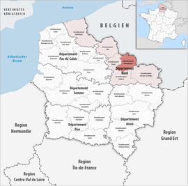 Location within the region Hauts-de-France | |
| Country | France |
| Region | Hauts-de-France |
| Department | Nord |
| No. of communes | 82 |
| Subprefecture | Valenciennes |
| Area | |
| • Total | 634.8 km2 (245.1 sq mi) |
| Population (2016) | |
| • Total | 351,260 |
| • Density | 553/km2 (1,430/sq mi) |
| INSEE code | 596 |
Composition
The communes of the arrondissement of Valenciennes, and their INSEE codes, are:[1]
- Abscon (59002)
- Anzin (59014)
- Artres (59019)
- Aubry-du-Hainaut (59027)
- Aulnoy-lez-Valenciennes (59032)
- Avesnes-le-Sec (59038)
- Bellaing (59064)
- Beuvrages (59079)
- Bouchain (59092)
- Bousignies (59100)
- Brillon (59109)
- Bruay-sur-l'Escaut (59112)
- Bruille-Saint-Amand (59114)
- Château-l'Abbaye (59144)
- Condé-sur-l'Escaut (59153)
- Crespin (59160)
- Curgies (59166)
- Denain (59172)
- Douchy-les-Mines (59179)
- Émerchicourt (59192)
- Escaudain (59205)
- Escautpont (59207)
- Estreux (59215)
- Famars (59221)
- Flines-lès-Mortagne (59238)
- Fresnes-sur-Escaut (59253)
- Hasnon (59284)
- Haspres (59285)
- Haulchin (59288)
- Haveluy (59292)
- Hélesmes (59297)
- Hergnies (59301)
- Hérin (59302)
- Hordain (59313)
- Lecelles (59335)
- Lieu-Saint-Amand (59348)
- Lourches (59361)
- Maing (59369)
- Marly (59383)
- Marquette-en-Ostrevant (59387)
- Mastaing (59391)
- Maulde (59393)
- Millonfosse (59403)
- Monchaux-sur-Écaillon (59407)
- Mortagne-du-Nord (59418)
- Neuville-sur-Escaut (59429)
- Nivelle (59434)
- Noyelles-sur-Selle (59440)
- Odomez (59444)
- Oisy (59446)
- Onnaing (59447)
- Petite-Forêt (59459)
- Préseau (59471)
- Prouvy (59475)
- Quarouble (59479)
- Quérénaing (59480)
- Quiévrechain (59484)
- Raismes (59491)
- Rœulx (59504)
- Rombies-et-Marchipont (59505)
- Rosult (59511)
- Rouvignies (59515)
- Rumegies (59519)
- Saint-Amand-les-Eaux (59526)
- Saint-Aybert (59530)
- Saint-Saulve (59544)
- Sars-et-Rosières (59554)
- Saultain (59557)
- Sebourg (59559)
- La Sentinelle (59564)
- Thiant (59589)
- Thivencelle (59591)
- Thun-Saint-Amand (59594)
- Trith-Saint-Léger (59603)
- Valenciennes (59606)
- Verchain-Maugré (59610)
- Vicq (59613)
- Vieux-Condé (59616)
- Wallers (59632)
- Wasnes-au-Bac (59645)
- Wavrechain-sous-Denain (59651)
- Wavrechain-sous-Faulx (59652)
History
The arrondissement of Valenciennes was created in 1800.[3]
As a result of the reorganisation of the cantons of France which came into effect in 2015, the borders of the cantons are no longer related to the borders of the arrondissements. The cantons of the arrondissement of Valenciennes were, as of January 2015:[4]
gollark: ?
gollark: <@319753218592866315> STOP PINGING @EVERYONE
gollark: I'm working on https://osmarks.tk/guihacker now
gollark: Also one for using the Lorem Ipsum thing a lot in one session.
gollark: Well, you can get one by visiting the site for an hour cumulatively.
References
- "Arrondissement de Valenciennes (596)". INSEE. Retrieved 2019-10-02.
- "Comparateur de territoire, géographie au 01/01/2019". INSEE. Retrieved 2019-10-02.
- Historique du Nord
- "Populations légales 2012" (PDF). INSEE. December 2014. Retrieved 2019-10-22.
| Authority control |
|
|---|
This article is issued from Wikipedia. The text is licensed under Creative Commons - Attribution - Sharealike. Additional terms may apply for the media files.