Armstrong Township, Lycoming County, Pennsylvania
Armstrong Township is a township in Lycoming County, Pennsylvania, United States. The population was 717 at the 2000 census. It is part of the Williamsport, Pennsylvania Metropolitan Statistical Area.
Armstrong Township, Lycoming County, Pennsylvania | |
|---|---|
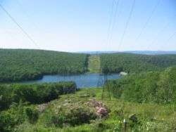 Hagermans Run Reservoir from PA Route 554, Armstrong Township | |
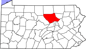
 Map of Lycoming County, Pennsylvania highlighting Armstrong Township | |
 Map of Lycoming County, Pennsylvania | |
| Coordinates: 41°12′17″N 77°1′48″W | |
| Country | United States |
| State | Pennsylvania |
| County | Lycoming |
| Settled | 1795 |
| Formed | 1842 |
| Area | |
| • Total | 25.50 sq mi (66.06 km2) |
| • Land | 24.74 sq mi (64.09 km2) |
| • Water | 0.76 sq mi (1.97 km2) 2.11%% |
| Elevation | 1,348 ft (582 m) |
| Population (2010) | |
| • Total | 681 |
| • Estimate (2016)[2] | 701 |
| • Density | 28.33/sq mi (10.94/km2) |
| Time zone | UTC-5 (Eastern Time Zone (North America)) |
| • Summer (DST) | UTC-4 (EDT) |
| ZIP code | 17702 |
| Area code(s) | 570 |
| FIPS code | 42-081-03072 |
| GNIS feature ID | 1216739[3] |
| Website | Armstrong Township |
History
The first European settlers arrived in Armstrong Township in 1773. Thomas Hartley, Michael Graybill, George Leffler, and John Kern all received warrants for land on February 11, 1773. Hartley then purchased the properties of Graybill, Leffler and Kern on March 31, 1773. This was to avoid a Province of Pennsylvania law that stated that no one man could purchase more than one tract of land. Marcus Huling appears to have been the first permanent settler in Mosquito Valley, which makes up the greatest portion of Armstrong Township. Huling settled in the eastern portion of Mosquito Valley, near where Culbertson's Path crossed. Huling and family cleared land, built a cabin, a sawmill, and distillery in 1795. Huling's son, Thomas, carried on the family businesses until his death. Although the Huling's were apparently successful businessmen, they never saw fit to settle their debt on the land that they had developed. Upon Thomas Huling's death, the land was foreclosed and was left to be reclaimed by nature until the arrival of German farmers in 1832.[4]
Armstrong Township was formed from part of Clinton Township in 1842. It is named in honor of James Armstrong, a prominent lawyer.
Mosquito Valley was cleared by the lumber companies that made nearby Williamsport the "Lumber Capital of the World." Lumberjacks harvested the old-growth forests of white pine and hemlock. They then floated the logs down Mosquito Run to the sawmills close to the mouth of the creek. As the valley was cleared of trees, farmers moved into the area and began several successful orchard and dairy operations.
Armstrong Township is not limited to Mosquito Valley alone. Bald Eagle Mountain runs through the northernmost portions of it. From this ridge, several mountain streams find their source. The lumber barons from Williamsport flocked to Mosquito Run in the south and western sections of the township and to Hagerman's Run in the eastern portion of the township. The barons built summer cottages on both streams, fished for trout in the waters, and built small dams for recreational swimming and ice skating. They also built several trout hatcheries in Mosquito Valley.
The Williamsport Municipal Water Authority quickly saw the value of the fresh water that was in abundant supply in both Mosquito and Hagerman's Runs. It acquired water rights to the streams and eventually bought up most of the farmland in the southwestern portion of Armstrong Township in the early 1920s as part of its watershed. Visitors to the "water company" lands can see the stone remains of the early settlers homesteads spread throughout the watershed. This mass purchase of farmland in Armstrong County has accounted for the steep decline in population since 1890. Mosquito Run and Hagerman's Run still provide drinking water for Williamsport.
The water authority built a multimillion-dollar water filtration plant in the 1990s in Mosquito Valley. With the construction of this plant the lands of the water authority were opened as a nature preserve to the general public.
Geography
Armstrong Township is bordered by Duboistown, South Williamsport, and the West Branch Susquehanna River to the north (with Williamsport, Loyalsock Township, and Montoursville north of the river), Brady and Clinton Townships to the south and east, Washington Township to the south, and Limestone, Bastress and Susquehanna Townships to the west. As the crow flies, Lycoming County is about 130 miles (209 km) northwest of Philadelphia and 165 miles (266 km) east-northeast of Pittsburgh.[5]
According to the United States Census Bureau, the township has a total area of 25.6 square miles (66 km2).25.0 square miles (64.8 km2) of it is land and 0.5 square miles (1.3 km2) of it (2.11%) is water.
Demographics
| Historical population | |||
|---|---|---|---|
| Census | Pop. | %± | |
| 2010 | 681 | — | |
| Est. 2016 | 701 | [2] | 2.9% |
| U.S. Decennial Census[6] | |||
As of the census[7] of 2000, there were 717 people, 294 households, and 204 families residing in the township. The population density was 28.6 people per square mile (11.1/km2). There were 334 housing units at an average density of 13.3/sq mi (5.2/km2). The racial makeup of the township was 99.30% White, 0.42% African American, 0.14% Native American, and 0.14% from two or more races. Hispanic or Latino of any race were 0.28% of the population.
There were 294 households, out of which 28.6% had children under the age of 18 living with them, 56.8% were married couples living together, 8.8% had a female householder with no husband present, and 30.6% were non-families. 25.9% of all households were made up of individuals, and 10.5% had someone living alone who was 65 years of age or older. The average household size was 2.44 and the average family size was 2.93.
In the township the population was spread out, with 23.3% under the age of 18, 4.6% from 18 to 24, 28.7% from 25 to 44, 28.7% from 45 to 64, and 14.6% who were 65 years of age or older. The median age was 42 years. For every 100 females there were 97.0 males. For every 100 females age 18 and over, there were 97.8 males.
The median income for a household in the township was $34,844, and the median income for a family was $42,031. Males had a median income of $32,188 versus $21,417 for females. The per capita income for the township was $18,423. About 6.5% of families and 9.4% of the population were below the poverty line, including 13.6% of those under age 18 and 3.4% of those age 65 or over.
See also
References
- "2016 U.S. Gazetteer Files". United States Census Bureau. Retrieved Aug 14, 2017.
- "Population and Housing Unit Estimates". Retrieved June 9, 2017.
- "US Board on Geographic Names". United States Geological Survey. 2007-10-25. Retrieved 2008-01-31.
- Meginness, John Franklin (1892). "Washington, Clinton, Armstrong, and Brady". History of Lycoming County, Pennsylvania: including its aboriginal history; the colonial and revolutionary periods; early settlement and subsequent growth; organization and civil administration; the legal and medical professions; internal improvement; past and present history of Williamsport; manufacturing and lumber interests; religious, educational, and social development; geology and agriculture; military record; sketches of boroughs, townships, and villages; portraits and biographies of pioneers and representative citizens, etc. etc (1st ed.). Chicago: Brown, Runk & Co. ISBN 0-7884-0428-8. Archived from the original on 1 March 2007. Retrieved 2007-02-20.
(Note: ISBN refers to Heritage Books July 1996 reprint. URL is to a scan of the 1892 version with some OCR typos).
- "2007 General Highway Map Lycoming County Pennsylvania" (PDF) (Map). 1:65,000. Pennsylvania Department of Transportation, Bureau of Planning and Research, Geographic Information Division. Retrieved 2009-12-24.
- "Census of Population and Housing". Census.gov. Retrieved June 4, 2016.
- "U.S. Census website". United States Census Bureau. Retrieved 2008-01-31.
Municipalities and communities of Lycoming County, Pennsylvania, United States | ||
|---|---|---|
| City | | |
| Boroughs | ||
| Townships |
| |
| CDPs | ||
| Unincorporated communities | ||
| Ghost town | ||
| Footnotes | ‡This populated place also has portions in an adjacent county | |