Armenia–Iran border
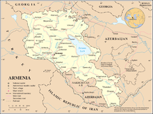
The Armenia–Iran border (Armenian: Հայաստան–Իրան սահման, romanized: Hayastan–Iran sahman, Persian: مرز ارمنستان-ایران) is 44 km (27 mi) in length and runs from the tripoint with Azerbaijan’s Nakhchivan region in the west to the tripoint with Azerbaijan proper in the east.[1]
Description
The border starts in the west at the western tripoint with Azerbaijan and runs along the Aras river to the eastern Azerbaijan tripoint.
History
During the 19th century the Caucasus region was contested between the declining Ottoman Empire, Persia and Russia, which was expanding southwards.[2] By the Russo-Persian War (1804–1813) and the subsequent Treaty of Gulistan, Russia acquired the bulk of what is now Azerbaijan and parts of Armenia; a border was drawn along the Aras river which is the modern border between Iran and Azerbaijan (excluding the Nakhchivan section) and Iran and Armenia.[2][3][4] Following the Russo-Persian War (1826–1828) and the Treaty of Turkmenchay Persia was forced to cede Nakhchivan and the rest of Armenia; the Aras was extended as the border up to the Ottoman tripoint, thus finalising what would become the Azerbaijan-Iran border.[2][5][4]
During the First World War Russian Communists staged a successful revolution in 1917, whilst the peoples of the southern Caucasus had declared the Transcaucasian Democratic Federative Republic in 1918. Internal disagreements led to Georgia leaving the federation in May 1918, followed shortly thereafter by Armenia and Azerbaijan. In 1920 Russia's Red Army invaded Azerbaijan and Armenia, ending the independence of both, followed shortly thereafter by Georgia. All three states were incorporated into the Transcaucasian SFSR within the USSR, before being separated in 1936. An Iran-USSR border convention in 1954 made some minor adjustment along the frontier in the Azeri sections of the border to Iran’s benefit.[2] On-the-ground demarcation then followed, with a final agreement being agreed upon in 1957.[2]

Following the collapse of the USSR in 1991 Armenia gained independence and inherited its section of the Iran-USSR border. Relations since then have been largely positive, with Iran suspicious of Azerbaijan’s potential claims to its territory. As a result of the Nagorno-Karabakh War, Armenia gained de facto control of the western-most section of the 'mainland' Azerbaijan border with Iran.
Border Crossings
The main crossing is at Nurduz-Agarak.[6]
See also
- Armenia-Iran relations
References
- CIA World Factbook – Iran, retrieved 6 April 2020
- International Boundary Study No. 25 – Iran-USSR Boundary (PDF), 28 February 1978, retrieved 9 April 2020
- John F. Baddeley, "The Russian Conquest of the Caucasus", Longman, Green and Co., London: 1908, p. 90
- USSR-Iran Boundary (PDF), February 1951, retrieved 9 April 2020
- Gavin R.G. Hambly, in The Cambridge History of Iran, ed. William Bayne Fisher (Cambridge University Press, 1991), pp. 145-146
- Caravanistan – Armenia-Iran border crossings, retrieved 9 April 2020