Angiari
Angiari is a comune (municipality) in the Province of Verona in the Italian region Veneto, located about 80 kilometres (50 mi) southwest of Venice and about 35 kilometres (22 mi) southeast of Verona. As of 31 December 2004, it had a population of 1,892 and an area of 13.5 square kilometres (5.2 sq mi).[3]
Angiari | |
|---|---|
| Comune di Angiari | |
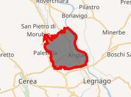
Location of Angiari 
| |
 Angiari Location of Angiari in Italy  Angiari Angiari (Veneto) | |
| Coordinates: 45°13′N 11°17′E | |
| Country | Italy |
| Region | Veneto |
| Province | Province of Verona (VR) |
| Area | |
| • Total | 13.5 km2 (5.2 sq mi) |
| Elevation | 17 m (56 ft) |
| Population (Dec. 2004)[2] | |
| • Total | 1,892 |
| • Density | 140/km2 (360/sq mi) |
| Demonym(s) | Angiaresi |
| Time zone | UTC+1 (CET) |
| • Summer (DST) | UTC+2 (CEST) |
| Postal code | 37050 |
| Dialing code | 0442 |
Angiari borders the following municipalities: Bonavigo, Cerea, Legnago, Roverchiara, and San Pietro di Morubio.
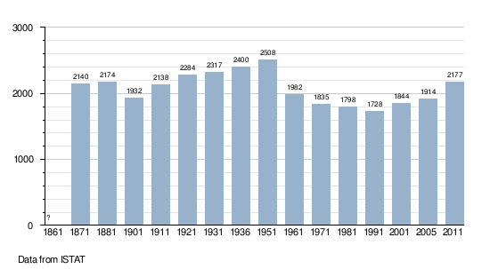
Demographic evolution

gollark: What were you ehhing about?
gollark: Oh, they b oot from EEPROM.
gollark: What?
gollark: This way it wouldn't affect GalactiCRAFT™™™.
gollark: ```category_fallupoutofworld { # Players above this height will get a freezing effect applied to them that slowly obscures their view D:freezingHeight=2000.0 # Players above this height will slowly lose air and take damage if they run out, similar to drowning D:noAirHeight=2500.0 # Players above this height will take rapid damage similar to falling out of the bottom of the world. D:bloodBoilHeight=3000.0 # Damage taken each tick while blood is boiling. 4 would be the same as falling out of the bottom of the world D:bloodBoilDamage=4.0 # Players above this height instantly die D:instantDeathHeight=4000.0}```in `UpAndDownAndAllAround.cfg`.<@!202992030685724675>
References
- "Superficie di Comuni Province e Regioni italiane al 9 ottobre 2011". Istat. Retrieved 16 March 2019.
- "Popolazione Residente al 1° Gennaio 2018". Istat. Retrieved 16 March 2019.
- All demographics and other statistics: Italian statistical institute Istat.
This article is issued from Wikipedia. The text is licensed under Creative Commons - Attribution - Sharealike. Additional terms may apply for the media files.