Aneroid, Saskatchewan
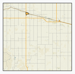
Aneroid (2016 population 50) is a special service area[2] in the Rural Municipality of Auvergne No. 76 in southwestern Saskatchewan, Canada. The community is located approximately 70 km southeast of Swift Current at the intersection of Highway 13 and Highway 612.
Aneroid | |
|---|---|
Special service area[1] | |
| Special Service Area of Aneroid | |
.jpg) Aneroid United Church | |
   | |
| Coordinates: 49.7155°N 107.2971°W | |
| Country | Canada |
| Province | Saskatchewan |
| Region | Saskatchewan |
| Census division | 4 |
| Rural Municipality | Auvergne |
| Post office Founded | February 1, 1911 |
| Village established | N/A |
| Restructured (special service area) | December 31, 2008 |
| Government | |
| • Former Mayor | Elton Meikle |
| • Former Administrator | Marcel Gervais |
| • Governing body | R.M. Auvergne No. 76 |
| • M.L.A. for Wood River | Dave Marit |
| • M.P. for Cypress Hills-Grasslands | Jeremy Patzer |
| Area | |
| • Total | 1.05 km2 (0.41 sq mi) |
| Population (2016) | |
| • Total | 50 |
| • Density | 47.5/km2 (123/sq mi) |
| Time zone | CST |
| Postal code | S0N 0C0 |
| Area code(s) | 306 |
| Highways | Highway 13 34 km east of junction #13 and #4 |
Demographics
Prior to December 31, 2008, Aneroid was incorporated as a village, and was restructured as a special service area under the jurisdiction of the Rural municipality of Invergordon on that date.[1][3]
| Canada census – Aneroid, Saskatchewan community profile | |||
|---|---|---|---|
| 2016 | 2011 | 2006 | |
| Population: | 50 (+25.0% from 2011) | 40 (-11.1% from 2006) | 45 (-19.6% from 2001) |
| Land area: | 1.05 km2 (0.41 sq mi) | 1.05 km2 (0.41 sq mi) | 1.05 km2 (0.41 sq mi) |
| Population density: | 47.5/km2 (123/sq mi) | 38.0/km2 (98/sq mi) | 42.8/km2 (111/sq mi) |
| Median age: | 44.5 (M: 44.4, F: 44.6) | Not Available (M: Not Available, F: Not Available) | 45.0 (M: 35.0, F: 49.0) |
| Total private dwellings: | 33 | 30 | 32 |
| Median household income: | $Not Available | $Not Available | $Not Available |
| References: 2016[4] 2011[5] 2006[6] earlier[7] | |||
History
The most popular version of the origin of the name is that the first survey party lost its aneroid barometer on the present townsite.[8] Many of the streets in the village are named after surveyor's instruments.[8]
The post office was established as Val Blair on February 1, 1911, and renamed Aneroid on December 1, 1913. Formerly a village, Aneroid was restructured as a special service area on December 31, 2008, under the administration of R.M. Auvergne No. 76.
Significant remaining historic buildings in the community include the 1915 Public School and the 1926 United Church. The two-storey, brick Public School was designed by Stanley Edgar Storey, one of the most significant architects in Saskatchewan;[9] it operated from 1915–97. The red-brick church was designed by architect Charles Nicholson and built in 1926.[10]
Infrastructure
- Saskatchewan Transportation Company used to provide intercity bus service to Aneroid; however, these operations were ceased in 2017.[11]
- Great Western Railway[12][13]
Notable residents
- Patrick Marleau, forward for the NHL team Pittsburgh Penguins
Climate
| Climate data for Aneroid (1981-2010) | |||||||||||||
|---|---|---|---|---|---|---|---|---|---|---|---|---|---|
| Month | Jan | Feb | Mar | Apr | May | Jun | Jul | Aug | Sep | Oct | Nov | Dec | Year |
| Record high °C (°F) | 14.4 (57.9) |
19.0 (66.2) |
22.8 (73.0) |
32.2 (90.0) |
37.5 (99.5) |
43.3 (109.9) |
41.1 (106.0) |
41.1 (106.0) |
38.0 (100.4) |
32.2 (90.0) |
23.0 (73.4) |
20.6 (69.1) |
43.3 (109.9) |
| Average high °C (°F) | −4.5 (23.9) |
−1.4 (29.5) |
4.5 (40.1) |
13.1 (55.6) |
19.1 (66.4) |
23.7 (74.7) |
27.2 (81.0) |
27.2 (81.0) |
20.1 (68.2) |
12.5 (54.5) |
2.7 (36.9) |
−3.6 (25.5) |
11.7 (53.1) |
| Daily mean °C (°F) | −10.3 (13.5) |
−7.3 (18.9) |
−1.5 (29.3) |
5.7 (42.3) |
11.5 (52.7) |
16.2 (61.2) |
19.1 (66.4) |
18.9 (66.0) |
12.4 (54.3) |
5.7 (42.3) |
−3.0 (26.6) |
−9.2 (15.4) |
4.9 (40.8) |
| Average low °C (°F) | −16.0 (3.2) |
−13.2 (8.2) |
−7.5 (18.5) |
−1.8 (28.8) |
4.0 (39.2) |
8.8 (47.8) |
11.0 (51.8) |
10.5 (50.9) |
4.7 (40.5) |
−1.2 (29.8) |
−8.6 (16.5) |
−14.9 (5.2) |
−2.0 (28.4) |
| Record low °C (°F) | −47.2 (−53.0) |
−46.1 (−51.0) |
−36.1 (−33.0) |
−29.4 (−20.9) |
−13.3 (8.1) |
−7.2 (19.0) |
0 (32) |
−3.3 (26.1) |
−12.8 (9.0) |
−25.0 (−13.0) |
−35.0 (−31.0) |
−47.0 (−52.6) |
−47.2 (−53.0) |
| Average precipitation mm (inches) | 18.6 (0.73) |
11.0 (0.43) |
22.1 (0.87) |
20.7 (0.81) |
53.8 (2.12) |
66.1 (2.60) |
62.9 (2.48) |
39.9 (1.57) |
38.0 (1.50) |
20.1 (0.79) |
15.0 (0.59) |
16.9 (0.67) |
385.2 (15.17) |
| Source: Environment Canada[14] | |||||||||||||
See also
| Wikimedia Commons has media related to Aneroid, Saskatchewan. |
References
- "Search for Municipal Information". Government of Saskatchewan. Archived from the original on March 10, 2014. Retrieved April 7, 2014.
- "Municipal Directory System" (PDF). Government of Saskatchewan. p. 225. Retrieved November 19, 2016.
- "Restructured Villages". Saskatchewan Ministry of Municipal Affairs. Archived from the original on March 25, 2008. Retrieved 2008-02-10.
- "2016 Community Profiles". 2016 Canadian Census. Statistics Canada. February 21, 2017. Retrieved 2017-07-04.
- "2011 Community Profiles". 2011 Canadian Census. Statistics Canada. July 5, 2013. Retrieved 2017-07-04.
- "2006 Community Profiles". 2006 Canadian Census. Statistics Canada. March 30, 2011. Retrieved 2009-02-24.
- "2001 Community Profiles". 2001 Canadian Census. Statistics Canada. February 17, 2012.
- Aneroid, The Rising Barometer, 1905-80, p. 1 (1980) Aneroid History Book Committee.
- "Biographical Dictionary of Architects in Canada".
- "Canadian Register of Historic Places".
- "STC Network Map" (PDF). Archived from the original (PDF) on 2013-10-04. Retrieved 2010-06-21.
- Great Western Railway
- Red Coat Road & Rail Ltd. - RCRR
- Environment Canada , accessed 5 October 2017
Places adjacent to Aneroid, Saskatchewan | ||||||||||
|---|---|---|---|---|---|---|---|---|---|---|
| ||||||||||
| Towns | 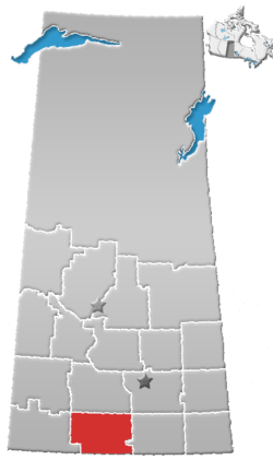 | ||||||
|---|---|---|---|---|---|---|---|
| Villages | |||||||
| Rural municipalities | |||||||
| First Nations |
| ||||||
| Indian reserves | |||||||
| Unincorporated communities |
| ||||||