Allen, Kansas
Allen is a city in Lyon County, Kansas, United States. As of the 2010 census, the city population was 177.[7]
Allen, Kansas | |
|---|---|
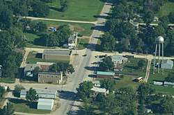 Aerial view of Allen (2013) | |
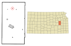 Location within Lyon County and Kansas | |
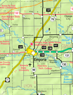 KDOT map of Lyon County (legend) | |
| Coordinates: 38°39′23″N 96°10′14″W | |
| Country | United States |
| State | Kansas |
| County | Lyon |
| Founded | 1854 |
| Incorporated | 1909 [1] |
| Government | |
| • Type | Mayor–Council |
| Area | |
| • Total | 0.28 sq mi (0.72 km2) |
| • Land | 0.28 sq mi (0.72 km2) |
| • Water | 0.00 sq mi (0.00 km2) |
| Elevation | 1,322 ft (403 m) |
| Population | |
| • Total | 177 |
| • Estimate (2019)[4] | 172 |
| • Density | 623.19/sq mi (240.29/km2) |
| Time zone | UTC-6 (CST) |
| • Summer (DST) | UTC-5 (CDT) |
| ZIP code | 66833 |
| Area code | 620 |
| FIPS code | 20-01275 [5] |
| GNIS ID | 0477038 [6] |
History
Allen was founded in 1854.[8] It was incorporated as a city in 1909.[9]
Allen was a station on the Missouri Pacific Railroad.[10]
Geography
Allen is located at 38°39′23″N 96°10′14″W (38.656472, -96.170511).[11] According to the United States Census Bureau, the city has a total area of 0.27 square miles (0.70 km2), all of it land.[12]
Climate
The climate in this area is characterized by hot, humid summers and generally mild to cool winters. According to the Köppen Climate Classification system, Allen has a humid subtropical climate, abbreviated "Cfa" on climate maps.[13]
Demographics
| Historical population | |||
|---|---|---|---|
| Census | Pop. | %± | |
| 1910 | 286 | — | |
| 1920 | 295 | 3.1% | |
| 1930 | 343 | 16.3% | |
| 1940 | 279 | −18.7% | |
| 1950 | 241 | −13.6% | |
| 1960 | 205 | −14.9% | |
| 1970 | 175 | −14.6% | |
| 1980 | 205 | 17.1% | |
| 1990 | 191 | −6.8% | |
| 2000 | 211 | 10.5% | |
| 2010 | 177 | −16.1% | |
| Est. 2019 | 172 | [4] | −2.8% |
| U.S. Decennial Census | |||
Allen is part of the Emporia Micropolitan Statistical Area.
2010 census
As of the census[3] of 2010, there were 177 people, 77 households, and 46 families residing in the city. The population density was 655.6 inhabitants per square mile (253.1/km2). There were 91 housing units at an average density of 337.0 per square mile (130.1/km2). The racial makeup of the city was 96.0% White, 2.3% from other races, and 1.7% from two or more races. Hispanic or Latino of any race were 4.0% of the population.
There were 77 households, of which 28.6% had children under the age of 18 living with them, 49.4% were married couples living together, 7.8% had a female householder with no husband present, 2.6% had a male householder with no wife present, and 40.3% were non-families. 36.4% of all households were made up of individuals, and 13% had someone living alone who was 65 years of age or older. The average household size was 2.30 and the average family size was 3.07.
The median age in the city was 42.4 years. 26% of residents were under the age of 18; 3.8% were between the ages of 18 and 24; 23.7% were from 25 to 44; 28.7% were from 45 to 64; and 17.5% were 65 years of age or older. The gender makeup of the city was 53.1% male and 46.9% female.
2000 census
As of the census[5] of 2000, there were 211 people, 83 households, and 62 families residing in the city. The population density was 768.7 people per square mile (301.7/km2). There were 93 housing units at an average density of 338.8 per square mile (133.0/km2). The racial makeup of the city was 98.10% White, 0.47% African American and 1.42% Native American. Hispanic or Latino of any race were 0.95% of the population.
There were 83 households, out of which 39.8% had children under the age of 18 living with them, 59.0% were married couples living together, 12.0% had a female householder with no husband present, and 25.3% were non-families. 24.1% of all households were made up of individuals, and 14.5% had someone living alone who was 65 years of age or older. The average household size was 2.54 and the average family size was 3.00.
In the city, the population was spread out, with 29.9% under the age of 18, 6.6% from 18 to 24, 28.4% from 25 to 44, 20.9% from 45 to 64, and 14.2% who were 65 years of age or older. The median age was 36 years. For every 100 females, there were 113.1 males. For every 100 females age 18 and over, there were 102.7 males.
The median income for a household in the city was $32,500, and the median income for a family was $39,792. Males had a median income of $30,000 versus $24,500 for females. The per capita income for the city was $15,855. About 10.2% of families and 8.0% of the population were below the poverty line, including 18.9% of those under the age of eighteen and none of those 65 or over.
Education
The community is served by North Lyon County USD 251 public school district, and home to Northern Heights High School. The Northern Heights High School mascot is Northern Heights Wildcats.
References
- "City of Allen". The League of Kansas Municipalities. May 24, 2019.
- "2019 U.S. Gazetteer Files". United States Census Bureau. Retrieved July 24, 2020.
- "U.S. Census website". United States Census Bureau. Retrieved 2012-07-06.
- "Population and Housing Unit Estimates". United States Census Bureau. May 24, 2020. Retrieved May 27, 2020.
- "U.S. Census website". United States Census Bureau. Retrieved 2008-01-31.
- "US Board on Geographic Names". United States Geological Survey. 2007-10-25. Retrieved 2008-01-31.
- "2010 City Population and Housing Occupancy Status". U.S. Census Bureau. Retrieved November 27, 2011.
- Kansas State Historical Society (1916). Biennial Report of the Board of Directors of the Kansas State Historical Society. Kansas State Printing Plant. pp. 229.
- Blackmar, Frank Wilson (1912). Kansas: A Cyclopedia of State History, Embracing Events, Institutions, Industries, Counties, Cities, Towns, Prominent Persons, Etc. Standard Publishing Company. pp. 59.
- Gannett, Henry (1898). A Gazetteer of Kansas. Govt. Print. Off. p. 25.
- "US Gazetteer files: 2010, 2000, and 1990". United States Census Bureau. 2011-02-12. Retrieved 2011-04-23.
- "US Gazetteer files 2010". United States Census Bureau. Archived from the original on January 12, 2012. Retrieved 2012-07-06.
- Climate Summary for Allen, Kansas
Further reading
External links
- City
- Maps
- Allen City Map, KDOT
Municipalities and communities of Lyon County, Kansas, United States | ||
|---|---|---|
| Cities |  Map of Kansas highlighting Lyon County | |
| Unincorporated communities | ||
| Townships | ||